Filtered by:
- Sale Section,
- Primary Category,
- Category
- List
- Grid
A subscription to the Price Guide is required to view results for auctions ten days or older. Click here for more information
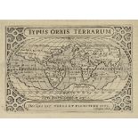

Bertius (Petrus). Tabularum Geographicarum Contractarum libri quinque..., 3rd edition, published
Bertius (Petrus). Tabularum Geographicarum Contractarum libri quinque..., 3rd edition, published Amsterdam, 1606, engraved title page with old ink...
Bohun (Edmund). A Geographical Dictionary: representing the present and ancient names of all the
Bohun (Edmund). A Geographical Dictionary: representing the present and ancient names of all the countries, provinces, remarkable cities, universi...
Guthrie (Mrs. Maria). A Tour Performed in the Years 1795-6, through The Taurida, or Crimea, the
Guthrie (Mrs. Maria). A Tour Performed in the Years 1795-6, through The Taurida, or Crimea, the Antient Kingdom of Bosphorus, the Once-Powerful Re...
Heylyn (Peter). Cosmography in Four Books. Containing the Chorography and History of the Whole
Heylyn (Peter). Cosmography in Four Books. Containing the Chorography and History of the Whole World: And all the Principal Kingdoms, Provinces, S...
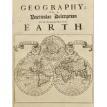
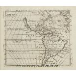
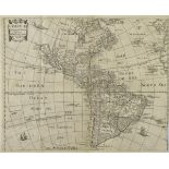
Moll (Herman). Thesaurus Geographicus, A New Body of Geography, or a Compleat Description of the
Moll (Herman). Thesaurus Geographicus, A New Body of Geography, or a Compleat Description of the Earth..., 1st edition, printed for Abel Swall and...
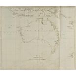
Pennant (Thomas). The View of India Extra Gangem, China, and Japan, & The View of The Malayan Isles,
Pennant (Thomas). The View of India Extra Gangem, China, and Japan, & The View of The Malayan Isles, New Holland, and The Spicy Islands (Outlines ...
Philip (George). Philips' General Atlas of the World, a series of new and authentic maps, engraved
Philip (George). Philips' General Atlas of the World, a series of new and authentic maps, engraved from original drawings compiled from the latest...
Reichard (Heinrich August Ottokar). Atlas Portatif et Itinéraire de L'Europe...., 8th edition,
Reichard (Heinrich August Ottokar). Atlas Portatif et Itinéraire de L'Europe...., 8th edition, published Weimar, 1818, additional half title, nine...
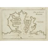
Roux (Joseph). Recueil de 155 des Principaux Plans des Ports et Rades de la Mediterrainée dont 32
Roux (Joseph). Recueil de 155 des Principaux Plans des Ports et Rades de la Mediterrainée dont 32 ont été derniérement publiés par Jean Joseph All...
Wilson (Robert Thomas). History of the British Expedition to Egypt; to which is subjoined, a Sketch of the Present State of that Country and its M...