Filtered by:
- Show only bulk lots,
- Sale Section,
- Creator / Brand
- List
- Grid
A subscription to the Price Guide is required to view results for auctions ten days or older. Click here for more information
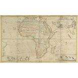

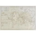
Africa. Moll (Herman), To the Right Honourable Charles Earl of Peterborow and Monmouth &c. This
Africa. Moll (Herman), To the Right Honourable Charles Earl of Peterborow and Monmouth &c. This Map of Africa According to ye Newest and most Exac...
Americas. A collection of approximately 110 maps, mostly 19th century, engraved and lithographic
Americas. A collection of approximately 110 maps, mostly 19th century, engraved and lithographic maps of North America and South America, includin...
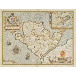
Anglesey. Speed (John), Anglesey antiently called Mona, 1st edition, published John Sudbury & George
Anglesey. Speed (John), Anglesey antiently called Mona, 1st edition, published John Sudbury & George Humble, [1611], hand coloured engraved map, i...
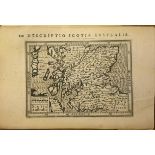
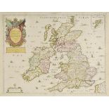
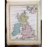
Bertius (Petrus). Scotia Australis, Warwicum Northampton Hunting etc., Eboracum Lincolnia Derbia
Bertius (Petrus). Scotia Australis, Warwicum Northampton Hunting etc., Eboracum Lincolnia Derbia Staffordia etc., Westmorlad: Lancastria cestris e...
British county maps. A mixed collection of approximately 220 British county maps, 17th - 19th
British county maps. A mixed collection of approximately 220 British county maps, 17th - 19th century, engraved maps, many with hand colouring, wi...
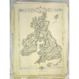
British Isles. A collection of ten maps, 17th century, engraved maps, six with hand colouring,
British Isles. A collection of ten maps, 17th century, engraved maps, six with hand colouring, with examples by Cluver, Sanson, Picart, Du Val, Ma...
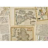
British Isles. Jansson (Jan), Pascaart vant Canaal tusschen Engelanten Vrancryck alsmede geheel
British Isles. Jansson (Jan), Pascaart vant Canaal tusschen Engelanten Vrancryck alsmede geheel Ierlant en Schotlant..., published Amsterdam, circ...
![British Isles. Jansson (Jan), Magnae Britanniae et Hiberniae tabula, [1631 or later], engraved map](https://portal-images.azureedge.net/auctions-2017/srdom10089/images/1d096e99-a246-4071-c7d6-a5f2646b77f8.jpg?w=155&h=155)
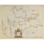
British Isles. Jansson (Jan), Magnae Britanniae et Hiberniae tabula, [1631 or later], engraved map
British Isles. Jansson (Jan), Magnae Britanniae et Hiberniae tabula, [1631 or later], engraved map with contemporary outline colouring, inset map ...
![British Isles. Ortelius (Abraham), Britannicarum Insularum Typus, [1603 or later], hand coloured](https://portal-images.azureedge.net/auctions-2017/srdom10089/images/913ed024-b7a1-45fe-ff8f-de6731b307fe.jpg?w=155&h=155)
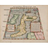
British Isles. Ortelius (Abraham), Britannicarum Insularum Typus, [1603 or later], hand coloured
British Isles. Ortelius (Abraham), Britannicarum Insularum Typus, [1603 or later], hand coloured engraved map orientated to the west, large strapw...
British Isles. Munster (Sebastian), Tubula Europae I, published Basle, circa 1545, hand coloured
British Isles. Munster (Sebastian), Tubula Europae I, published Basle, circa 1545, hand coloured woodcut map within a trapezoidal frame, two panel...
British Isles. Blome (Richard), A Generall Mapp of the Isles of Great Brittaine, Designed by
British Isles. Blome (Richard), A Generall Mapp of the Isles of Great Brittaine, Designed by Monsieur Sanson..., 1669, engraved map with contempor...
![Cape Verde Islands. Coronelli (Vicenzo Maria), Bocche del Fiume Negro et Isole di Capo Verde [and]](https://portal-images.azureedge.net/auctions-2017/srdom10089/images/05c805f3-ad6b-4f4d-ec3c-d49f65a382df.jpg?w=155&h=155)
Cape Verde Islands. Coronelli (Vicenzo Maria), Bocche del Fiume Negro et Isole di Capo Verde [and]
Cape Verde Islands. Coronelli (Vicenzo Maria), Bocche del Fiume Negro et Isole di Capo Verde [and] Abissinia doue sono le Fonti del Nilo, publishe...
China. A collection of thirteen uncoloured engraved sea charts, 1796 - 1798, sea charts, engraved by
China. A collection of thirteen uncoloured engraved sea charts, 1796 - 1798, sea charts, engraved by B. Baker and G. Neele, one with later outlin...
Coronelli (Vincenzo Maria). Two untitled maps/globe gores of the North & South poles, circa 1690,
Coronelli (Vincenzo Maria). Two untitled maps/globe gores of the North & South poles, circa 1690, two uncoloured engraved circular gores or calott...
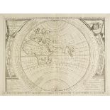
Eastern Hemisphere. Coronelli (Vicenzo Maria), Aevi Veteris Usque Ad Annum Salutis Nonagesimum Supra
Eastern Hemisphere. Coronelli (Vicenzo Maria), Aevi Veteris Usque Ad Annum Salutis Nonagesimum Supra Milles Quadringentos Cogniti Tantum Typus Geo...
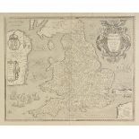
England & Wales. Le Clerc (Jean), Anglia Regnum si quod aliud in toto Oceano ditissimum et florentissimum, published Paris, 1606, uncoloured engra...
![England & Wales. Hole (William), Englalond Anglia Anglosaxonum Heptarchia, [1637], uncoloured](https://portal-images.azureedge.net/auctions-2017/srdom10089/images/e9627de4-3339-4cc2-b882-e706a5f03c9f.jpg?w=155&h=155)
England & Wales. Hole (William), Englalond Anglia Anglosaxonum Heptarchia, [1637], uncoloured
England & Wales. Hole (William), Englalond Anglia Anglosaxonum Heptarchia, [1637], uncoloured engraved map, slight creasing and spotting largely c...
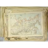
England & Wales. A collection of seventy maps, 19th century, engraved and lithographic maps, with
England & Wales. A collection of seventy maps, 19th century, engraved and lithographic maps, with examples by Stanford, Betts, Stulpnagel, Weller,...
England & Wales. Mercator (Gerard & Hondius Henricus), Northumbria, Cumberlandia et Dunelmensis
England & Wales. Mercator (Gerard & Hondius Henricus), Northumbria, Cumberlandia et Dunelmensis episcopatus [and] Eboracum, Lincolnia, Derbia, Sta...
England & Wales. Kitchin (Thomas), Karte von England und Wallis..., 1787, uncoloured engraved map on
England & Wales. Kitchin (Thomas), Karte von England und Wallis..., 1787, uncoloured engraved map on four sheets, sectionalised and laid on linen,...
Europe. A mixed collection of approximately 175 maps, mostly 19th century, engraved maps of the
Europe. A mixed collection of approximately 175 maps, mostly 19th century, engraved maps of the continent and various countries, with examples by ...
Europe. A mixed collection of thirty-two maps of the continent, European countries and regions,
Europe. A mixed collection of thirty-two maps of the continent, European countries and regions, mostly 17th & 18th century, including examples by ...
Folding maps. A mixed collection of five maps, 19th century, including Cary (John), Cary's New Map
Folding maps. A mixed collection of five maps, 19th century, including Cary (John), Cary's New Map of Ireland exhibiting the whole of the Turnpike...
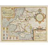
Glamorganshire. Speed (John), Glamorgan Shyre with the sittuations of the cheife towne Cardyff and
Glamorganshire. Speed (John), Glamorgan Shyre with the sittuations of the cheife towne Cardyff and ancient Landaffe described, 1st edition, publis...
![Greece & Montenegro. Coronelli (Vicenzo Maria), Golfo della Prevesa [and] Disegno Topograpfico el](https://portal-images.azureedge.net/auctions-2017/srdom10089/images/a4be555d-51f5-4924-cefd-13950f0b3ce9.jpg?w=155&h=155)
Greece & Montenegro. Coronelli (Vicenzo Maria), Golfo della Prevesa [and] Disegno Topograpfico el
Greece & Montenegro. Coronelli (Vicenzo Maria), Golfo della Prevesa [and] Disegno Topograpfico el Canale di Cattaro, published Venice, circa. 1690...
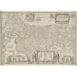
Herefordshire. A mixed collection of approximately sixty maps, mostly 19th century, engraved and
Herefordshire. A mixed collection of approximately sixty maps, mostly 19th century, engraved and lithographic maps, including examples by Cary, La...
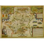
Herefordshire. Speed (John), Herefordshire described with the true plot of the citie Hereford as
Herefordshire. Speed (John), Herefordshire described with the true plot of the citie Hereford as also the armes of thos Nobles that have bene inti...
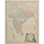
India. A mixed collection of ten maps, 18th & 19th century, engraved maps, many with contemporary
India. A mixed collection of ten maps, 18th & 19th century, engraved maps, many with contemporary outline colouring, including examples by Wyld, J...
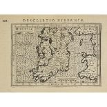
Ireland. Bertius (Pieter), Hibernia, Hibernia Septentr. in qua Ultonia Connatia, Hibernia Austral in
Ireland. Bertius (Pieter), Hibernia, Hibernia Septentr. in qua Ultonia Connatia, Hibernia Austral in qua Momonia Lagenia, Connatia, Lagenia, Udron...
Kohler (Johann David). [Descriptio Orbis Antiqui in XLIV tabulis exhibita, published Nuremberg,
Kohler (Johann David). [Descriptio Orbis Antiqui in XLIV tabulis exhibita, published Nuremberg, 1720], lacking titles and preliminaries, thirteen ...
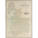
Lancashire. Hennet (George), A Map of the County Palatine of Lancaster Divided into Hundreds and
Lancashire. Hennet (George), A Map of the County Palatine of Lancaster Divided into Hundreds and Parishes from an Accurate Survey done in the Year...
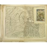
![Latvia. Olearius (Adam), Riga, published Leiden, [1719], uncoloured engraved town plan, old folds,](https://portal-images.azureedge.net/auctions-2017/srdom10089/images/d8d9065e-115e-4703-8065-d8bbfde7e33c.jpg?w=155&h=155)
Latvia. Olearius (Adam), Riga, published Leiden, [1719], uncoloured engraved town plan, old folds,
Latvia. Olearius (Adam), Riga, published Leiden, [1719], uncoloured engraved town plan, old folds, 405 x 510 mm Originally published by Pieter van...
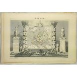
Levasseur (Victor). A collection of approximately eighty maps, circa 1850, engraved decorative
Levasseur (Victor). A collection of approximately eighty maps, circa 1850, engraved decorative maps of French departments and regional maps, conte...
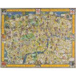
London. Gill (Macdonald), The Wonderground Map of London Town, published The Westminster press,
London. Gill (Macdonald), The Wonderground Map of London Town, published The Westminster press, circa 1928, colour photolithographic map, old fold...
London. Bodenehr (Gabriel), Londen, Westmunster u: Soudwark, published Augsburg, circa 1710.
London. Bodenehr (Gabriel), Londen, Westmunster u: Soudwark, published Augsburg, circa 1710. uncoloured engraved map on two conjoined sheets, titl...
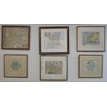
*Maps. A mixed collection of six maps, 17th - 19th century, including Blaeu (Johannes), Essexia
*Maps. A mixed collection of six maps, 17th - 19th century, including Blaeu (Johannes), Essexia comitatus, published Amsterdam, circa 1650, engrav...
Maps. A mixed collection of approximately 220 maps, mostly 19th century, engraved and lithographic
Maps. A mixed collection of approximately 220 maps, mostly 19th century, engraved and lithographic foreign maps of Europe, Middle East, Australasi...
Maps. A mixed collection of approximately 175 maps, mostly 19th & early 20th century, engraved and
Maps. A mixed collection of approximately 175 maps, mostly 19th & early 20th century, engraved and lithographic battle plans, foreign maps and Bri...
Maps A mixed of collection of approximately 100 maps, 18th & 19th century, engraved and lithographic
Maps A mixed of collection of approximately 100 maps, 18th & 19th century, engraved and lithographic maps of British counties, town plans and over...
Monmouthshire. Speed (John), The Countye of Monmouth with the sittuation of the Shire-towne described, 1st edition, published John Sudbury and Geo...
Moxon (Joseph). A Map of all the Earth and how after the flood it was divided among the sons of
Moxon (Joseph). A Map of all the Earth and how after the flood it was divided among the sons of Noah, Paradise or the Garden of Eden with the Coun...
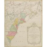
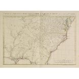
North America. Lotter (Mathais Albrecht), Carte Nouvelle de L'Amerique Angloise contenant tout ce
North America. Lotter (Mathais Albrecht), Carte Nouvelle de L'Amerique Angloise contenant tout ce que les Anglois possedent sur le Continent de L'...
North America. Covens (Johannes & Mortier Cornelis), Carte de la Louisiane, Maryland, Virginie,
North America. Covens (Johannes & Mortier Cornelis), Carte de la Louisiane, Maryland, Virginie, Caroline, Georgie avec une partie de la Floride, p...
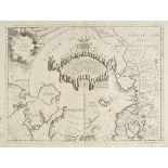
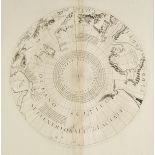
North Pole. North Pole. Coronelli (Vicenzo Maria), Terre Artiche descritte Dal. P.M.Coronelli M.C.
North Pole. North Pole. Coronelli (Vicenzo Maria), Terre Artiche descritte Dal. P.M.Coronelli M.C. Cosmografo della Serrenis Republica di Venetia....
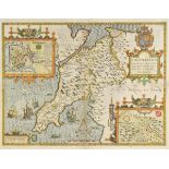
North Wales. Speed (John), Caeernarvon both Shyre and shire-towne with the ancient citie Bangor
North Wales. Speed (John), Caeernarvon both Shyre and shire-towne with the ancient citie Bangor described, Flint-Shire [and] Denbigh Shire, all fi...
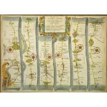
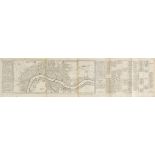
Ogilby (John). The Road from London to Dover in co. Canty, actually survey'd & Delineated, [1676
Ogilby (John). The Road from London to Dover in co. Canty, actually survey'd & Delineated, [1676 or later], hand coloured engraved strip road map,...
![Ogilby (John). The Roads from York to Whitby and Scarborough in Yorkshire, [1698], hand coloured](https://portal-images.azureedge.net/auctions-2017/srdom10089/images/5f14ca05-ac5a-4247-b2ea-4aa4863e3e14.jpg?w=155&h=155)
Ogilby (John). The Roads from York to Whitby and Scarborough in Yorkshire, [1698], hand coloured
Ogilby (John). The Roads from York to Whitby and Scarborough in Yorkshire, [1698], hand coloured engraved strip road map, decorative cartouche sho...
Pembrokeshire. Speed (John), Penbrokshyre described and the sittuations both of Penbroke and St.
Pembrokeshire. Speed (John), Penbrokshyre described and the sittuations both of Penbroke and St. Davids shewed in due form as they were taken..., ...
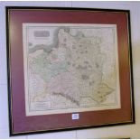
*Poland. De Wit (Frederick), Regni Poloniae et Ducatus Lithuaniae, Voliniae, Podoliae, Ucraniae,
*Poland. De Wit (Frederick), Regni Poloniae et Ducatus Lithuaniae, Voliniae, Podoliae, Ucraniae, Prussiae, Livoniae et Curlandiae, published Amste...
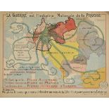
Propaganda maps. La Guerre est L'Industrie Nationale de la Prusse/ Le Rêve Allemand, published P. J.
Propaganda maps. La Guerre est L'Industrie Nationale de la Prusse/ Le Rêve Allemand, published P. J. Gallais, Paris, 1918, French colour lithograp...
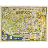
Quebec. Maw (S. H.), The City of Quebec with historical notes, published Alexander & Cable, Toronto,
Quebec. Maw (S. H.), The City of Quebec with historical notes, published Alexander & Cable, Toronto, 1932, bright colour lithographic folding map,...
Rapkin (J.). A collection of approximately ninety-five engraved maps, circa 1870, uncoloured
Rapkin (J.). A collection of approximately ninety-five engraved maps, circa 1870, uncoloured engraved maps from the second edition (lacking the vi...
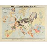
Satirical map. Gedrängte Fruhjahrsubersicht von Europa im Jahre 1915. Masstab bis auf weiteres 3
Satirical map. Gedrängte Fruhjahrsubersicht von Europa im Jahre 1915. Masstab bis auf weiteres 3 gegm 7, published Lucas grafe, Hamburg, 1915, col...
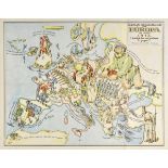
Satirical map. European Revue. Kill that Eagle, published Geographia Ltd, London, 1915, colour
Satirical map. European Revue. Kill that Eagle, published Geographia Ltd, London, 1915, colour lithographic map of Europe after J. H. Amschewitz, ...
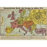
Satirical map. Lehmann-Dumont (Karl), Humoristische Karte von Europa im Jahre 1914, published
Satirical map. Lehmann-Dumont (Karl), Humoristische Karte von Europa im Jahre 1914, published Dresden, 1914, colour printed photolithographic alle...
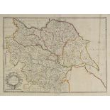
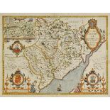
Saxton (Christopher & Lea Philip,), York - Shire described by Ch: Saxton. Many additions and
Saxton (Christopher & Lea Philip,), York - Shire described by Ch: Saxton. Many additions and Corrections as ye Roads, Wapontakes &c. by P. Lea, [1...
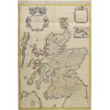
Scotland. Overton (Henry), A New and Exact Mapp of Scotland or North-Britain, described by N.Sanson,
Scotland. Overton (Henry), A New and Exact Mapp of Scotland or North-Britain, described by N.Sanson, Geographer to the French King, Translated int...
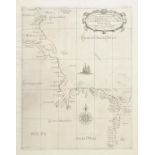
Sea charts. Dudley (Sir Robert), Carta particolare della costa di Inghilterra che comincia a
Sea charts. Dudley (Sir Robert), Carta particolare della costa di Inghilterra che comincia a Fyleberg e finisce con Il. C. di S. Tabs in Ischosia ...
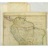
South America. Moll (Herman), To the Right Honourable Charles Earl of Sunderland and Baron Spencer
South America. Moll (Herman), To the Right Honourable Charles Earl of Sunderland and Baron Spencer of Wormleighton, One of Her Majesty's Principal...
St. Helena. Van der Aa (Pieter), Isle St. Helene, published Leiden, circa 1715, uncoloured engraved map, compass rose and table of explanation, 25...