Refine your search
Sale Section
Estimate
Category
- Books & Periodicals (356)
- Maps (169)
- Prints (70)
- Metalware (15)
- Tools (13)
- Furniture (12)
- Watercolours (6)
- Collectables (5)
- Vintage Fashion (5)
- Ceramics (4)
- Photographs (3)
- Watches & Watch accessories (2)
- Arms, Armour & Militaria (1)
- Coins (1)
- Drawings & Pastels (1)
- Models, Toys, Dolls & Games (1)
- Textiles (1)
Filtered by:
- Item Type
- List
- Grid
A subscription to the Price Guide is required to view results for auctions ten days or older. Click here for more information
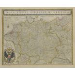

Germany. Blaeu (Johannes) Nova totius Germaniae descriptio, published Amsterdam, circa 1648,
Germany. Blaeu (Johannes) Nova totius Germaniae descriptio, published Amsterdam, circa 1648, engraved map with contemporary outline colouring, occ...
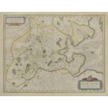
Germany. Blaeu (Johannes), Oldenburg comitatus, Saxonia Superior Lusatia misnia, Monasteriensis
Germany. Blaeu (Johannes), Oldenburg comitatus, Saxonia Superior Lusatia misnia, Monasteriensis Episcopatus, Ducatus Brunsvicensis fereq Lunaeburg...
![Gibson (John). Great Britain and Ireland, England and Wales, Scotland [and] Ireland, [1759], set](https://portal-images.azureedge.net/auctions-2017/srdom10087/images/0c128832-fb86-404d-8cf3-78014bc15882.jpg?w=155&h=155)
Gibson (John). Great Britain and Ireland, England and Wales, Scotland [and] Ireland, [1759], set
Gibson (John). Great Britain and Ireland, England and Wales, Scotland [and] Ireland, [1759], set of four uncoloured engraved miniature maps, each ...
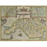
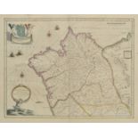
*Glamorganshire. Speed (John), Glamorgan Shyre with the sittuations of the cheife towne Cardyff
*Glamorganshire. Speed (John), Glamorgan Shyre with the sittuations of the cheife towne Cardyff and ancient Landaffe described, published John Sud...
Gloucestershire. Glocestria ducatus vulgo Glocestershire, published Amsterdam, circa 1648, engraved map with bright contemporary outline colouring...
Goa. Van Linschoten (Jan Huygen), Ailhae Cidade de Goa Metropolitana da Indiae partes Orientais
Goa. Van Linschoten (Jan Huygen), Ailhae Cidade de Goa Metropolitana da Indiae partes Orientais que esta en 15 Graos da Banda do Norte, circa 1598...
*Grenada. Bellin (Jacques Nicolas), Carte de L'Isle de la Grenade, published Paris, 1760, hand
*Grenada. Bellin (Jacques Nicolas), Carte de L'Isle de la Grenade, published Paris, 1760, hand coloured engraved sea chart, inset horizon profile,...
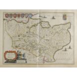
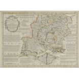
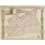
Herefordshire. A mixed collection of approximately sixty maps, mostly 19th century, engraved and
Herefordshire. A mixed collection of approximately sixty maps, mostly 19th century, engraved and lithographic maps, including examples by Cary, La...
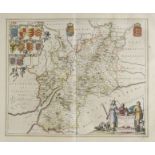
Herefordshire. Speed (John), Herefordshire described with the true plot of the citie Hereford as
Herefordshire. Speed (John), Herefordshire described with the true plot of the citie Hereford as also the armes of thos Nobles that have bene inti...
Hertfordshire. Blaeu (Johannes), Hertfordia comitatus vernacule Hertfordshire, published Amsterdam, circa 1648, engraved map with contemporary out...
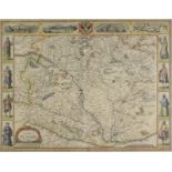
*Hungary. Speed (John), The Mape of Hungari newly augmented..., published George Humble, circa 1627,
*Hungary. Speed (John), The Mape of Hungari newly augmented..., published George Humble, circa 1627, hand coloured engraved carte-a-figure map, ei...
India. Pierson (Francis, Royal Engineers, Surveyor), Sketch of Road from Baghdad to Khanuakin,
India. Pierson (Francis, Royal Engineers, Surveyor), Sketch of Road from Baghdad to Khanuakin, 29th February 1864, manuscript pen and ink map with...
![India. Jansson (Jan), Sinus Gangeticus vulgo Golfo de Bengala nova descriptio [and] Insula Zeilan](https://portal-images.azureedge.net/auctions-2017/srdom10087/images/7254d6b6-2389-41f9-8c4e-6d541866751b.jpg?w=155&h=155)
India. Jansson (Jan), Sinus Gangeticus vulgo Golfo de Bengala nova descriptio [and] Insula Zeilan
India. Jansson (Jan), Sinus Gangeticus vulgo Golfo de Bengala nova descriptio [and] Insula Zeilan olim Taprobana nunc incolis Tenarisim, published...
Ireland. Speed (John), The Province of Connaugh with the citie of Galwaye described, published
Ireland. Speed (John), The Province of Connaugh with the citie of Galwaye described, published John Sudbury and George Humble, circa 1627, uncolou...
![Ireland. Ortelius (Abraham), Eryn. Hiberniae Britannicae Insulae nova descriptio, [1592]](https://portal-images.azureedge.net/auctions-2017/srdom10087/images/d9e67100-cf18-43ca-8e95-13157359ccec.jpg?w=155&h=155)
Ireland. Ortelius (Abraham), Eryn. Hiberniae Britannicae Insulae nova descriptio, [1592] uncoloured engraved map orientated to the east, large st...
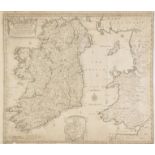
Ireland. Lea (Philip), An Epitome of Sr. William Petty's large survey of Ireland..., circa 1690,
Ireland. Lea (Philip), An Epitome of Sr. William Petty's large survey of Ireland..., circa 1690, uncoloured map engraved by Sutton Nicholls, inset...
Ireland. A mixed collection of five maps, mostly 18th century, including Porcacchi (Tomaso),
Ireland. A mixed collection of five maps, mostly 18th century, including Porcacchi (Tomaso), Descrittione dell' isola D'Irlanda, published Venice,...
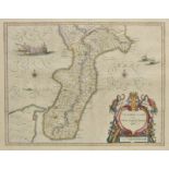
Italy. Blaeu (Johannes), Calabria ultra olim Altera Magnae Graeciae pars, Principato citra olim
Italy. Blaeu (Johannes), Calabria ultra olim Altera Magnae Graeciae pars, Principato citra olim Picentia, Calabria citra olim Magna Graecia, Terra...
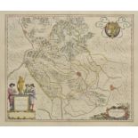
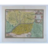
Italy. Blaeu (Johannes), Territorio de Vicenza, Ducato di Urbino, Polesino di Rovigo, Ducato di
Italy. Blaeu (Johannes), Territorio de Vicenza, Ducato di Urbino, Polesino di Rovigo, Ducato di Modena regio et Carpi, Territorio di Verona [and] ...
*Java. Van Keulen (Gerard), Insulae Iavae Pars Occidentalis Edente Hadriano Relando / Insulae
*Java. Van Keulen (Gerard), Insulae Iavae Pars Occidentalis Edente Hadriano Relando / Insulae Iavae Pars Orientalis Edente Hadriano Relando, publi...
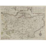
Kent. Blaeu (Johannes), Cantium vernacule Kent, published Amsterdam, circa 1648, engraved map with
Kent. Blaeu (Johannes), Cantium vernacule Kent, published Amsterdam, circa 1648, engraved map with contemporary outline colouring, slight staining...
Leicestershire & Rutland. Blaeu (Johannes), Leicestrensis comitatus. Leicester Shire [and] Rutlandia
Leicestershire & Rutland. Blaeu (Johannes), Leicestrensis comitatus. Leicester Shire [and] Rutlandia comitatus. Rutland Shire, published Amsterdam...
Liverpool. Lord (Lieut. William, R.N.), A Chart of the Approaches to Liverpool from a Survey made by
Liverpool. Lord (Lieut. William, R.N.), A Chart of the Approaches to Liverpool from a Survey made by the direction of the Trustees of the Liverpoo...
London. Gill (Macdonald), Wonderground Map of the London Town, published The Westminster Press,
London. Gill (Macdonald), Wonderground Map of the London Town, published The Westminster Press, circa 1928, colour photolithographic map, old fold...
London. Environs of London - Windsor Castle to Gravesend, published 'The Illustrated London News', [1855], uncoloured engraved map by John Dower, ...
Mallet (Alain Manesson). A collection of approximately 230 maps, engravings and plans, circa 1685,
Mallet (Alain Manesson). A collection of approximately 230 maps, engravings and plans, circa 1685, uncoloured engraved maps, plans, views, social ...
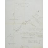
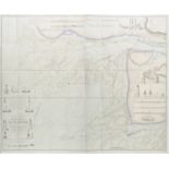
Manuscript maps. The Frome Highway District, circa 1820, pen, ink and watercolour map laid on linen,
Manuscript maps. The Frome Highway District, circa 1820, pen, ink and watercolour map laid on linen, explanation code to the various types of road...
Maps. A mixed collection of approximately sixty maps, mostly 18th & 19th century, including approximately fifty British county and regional maps, ...
Maps. A mixed collection of approximately 130 maps, mostly 19th century, including twenty double
Maps. A mixed collection of approximately 130 maps, mostly 19th century, including twenty double page engraved maps by George Philip, circa 1852, ...
Maps. A mixed collection of fourteen maps, 16th - 19th century, overseas maps and charts of regions and countries including France, Europe, Russia...
Maps. A good mixed collection of approximately 175 maps, 17th - 19th century, engraved maps of
Maps. A good mixed collection of approximately 175 maps, 17th - 19th century, engraved maps of China, Japan, India, Africa, Europe and Asia, inclu...
*Merionethshire. Speed (John), Merionethshire described, George Humble, circa 1627, hand coloured
*Merionethshire. Speed (John), Merionethshire described, George Humble, circa 1627, hand coloured engraved map, inset town plan of Harlech, strapw...
![Mexico. Ortelius (Abraham), Hispaniae novae sivae magnae recens et vera descriptio, [1592 - 1612],](https://portal-images.azureedge.net/auctions-2017/srdom10087/images/c01e709e-b2c5-4fa9-9a91-4408bb857004.jpg?w=155&h=155)
Mexico. Ortelius (Abraham), Hispaniae novae sivae magnae recens et vera descriptio, [1592 - 1612],
Mexico. Ortelius (Abraham), Hispaniae novae sivae magnae recens et vera descriptio, [1592 - 1612], engraved map, large ornate strapwork cartouche,...
Middlesex & Hertfordshire. Jansson (Jan), Middelsexiae cum Hertfordiae comitatu Midlesex & Hertfordshire, published Amsterdam, circa 1650, engrave...
*Monmouthshire. Saxton (Christopher & Hole William), Monumethensis comitatus quem olim incoluerunt
*Monmouthshire. Saxton (Christopher & Hole William), Monumethensis comitatus quem olim incoluerunt silures, circa 1610, hand coloured engraved map...
![*Montgomeryshire. Speed (John), Montgomery Shire, published John Sudbury & George Humble, [1627],](https://portal-images.azureedge.net/auctions-2017/srdom10087/images/0a87cc6c-dafe-426f-830c-2c607a26b7a6.jpg?w=155&h=155)
*Montgomeryshire. Speed (John), Montgomery Shire, published John Sudbury & George Humble, [1627],
*Montgomeryshire. Speed (John), Montgomery Shire, published John Sudbury & George Humble, [1627], hand coloured engraved map, inset town plan of M...
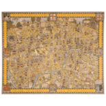
![Morden (Robert). A collection of forty-two maps, [1695 or later], engraved maps, mostly of midland](https://portal-images.azureedge.net/auctions-2017/srdom10087/images/ca95ccac-9037-44a2-93ab-4255f47c5530.jpg?w=155&h=155)
Morden (Robert). A collection of forty-two maps, [1695 or later], engraved maps, mostly of midland
Morden (Robert). A collection of forty-two maps, [1695 or later], engraved maps, mostly of midland and eastern counties, several with hand colouri...
Moule (Thomas). A collection of approximately 120 engraved maps, circa 1845, engraved county maps
Moule (Thomas). A collection of approximately 120 engraved maps, circa 1845, engraved county maps and town plans, some with hand colouring, severa...
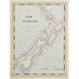
New Zealand. Pickstock (J. W.), New Zealand, 1842, pen, ink and watercolour map, artist's name and
New Zealand. Pickstock (J. W.), New Zealand, 1842, pen, ink and watercolour map, artist's name and date below title, slight dust soiling largely c...
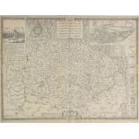
Norden (John and Kip, William). Cantium quod nunc Kent, Middlesex olima trinoban tibus habitata [
Norden (John and Kip, William). Cantium quod nunc Kent, Middlesex olima trinoban tibus habitata [and] Hertfordiae comitatusa A. cattifuclanis olim...
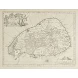
Norfolk. Speed (John), Norfolk. A Countie florishing & populous. Described and devided, with the
Norfolk. Speed (John), Norfolk. A Countie florishing & populous. Described and devided, with the armes of such noble families as have borne the ti...
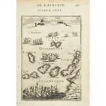
![North America. Porcacchi (Tomaso), Mondo Nuovo, published Venice, [1572 or later], uncoloured](https://portal-images.azureedge.net/auctions-2017/srdom10087/images/f118e4e6-accd-435d-c5e8-be7398a14ae4.jpg?w=155&h=155)
North America. Porcacchi (Tomaso), Mondo Nuovo, published Venice, [1572 or later], uncoloured
North America. Porcacchi (Tomaso), Mondo Nuovo, published Venice, [1572 or later], uncoloured engraved map, Italian text below and on verso of map...
Northamptonshire. Speed (John), Northamtonshire, 1st edition, published George Humble, circa 1611,
Northamptonshire. Speed (John), Northamtonshire, 1st edition, published George Humble, circa 1611, uncoloured engraved map, inset town plans of No...
Northern counties. Morden (Robert), A collection of eleven maps, [1695 or later], engraved county
Northern counties. Morden (Robert), A collection of eleven maps, [1695 or later], engraved county maps, eight with hand colouring, each approximat...
Ogilby (John). The Continuation of the Road from London to St. Davids comencing at Monmouth &
Ogilby (John). The Continuation of the Road from London to St. Davids comencing at Monmouth & extending to Burton Ferry com Glamorgan, The Continu...
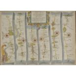
Ogilby (John). The Road from London to Dover in co. Canty, actually survey'd & Delineated, [1676
Ogilby (John). The Road from London to Dover in co. Canty, actually survey'd & Delineated, [1676 or later], hand coloured engraved strip road map,...
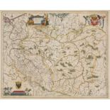
Ortelius (Abraham). Germaniae veteris typus, Belgii veteris typus, Helevtiae descriptio aegidio
Ortelius (Abraham). Germaniae veteris typus, Belgii veteris typus, Helevtiae descriptio aegidio tschudo auct. [and] Pannoniae et Illyrici veteris ...
Poland. Blaeu (Johannes), Polonia regnum et Silesia ducatus, published Amsterdam, circa 1648,
Poland. Blaeu (Johannes), Polonia regnum et Silesia ducatus, published Amsterdam, circa 1648, engraved map with contemporary outline colouring, 41...

Porcacchi (Tomaso). A collection of thirty-nine maps, originally published in 'La Isole piu famaso
Porcacchi (Tomaso). A collection of thirty-nine maps, originally published in 'La Isole piu famaso del Mondo', published Venice, [1572 or later], ...
Reference. A mixed collection of eighteen map reference books and facsimile atlases, 20th century,
Reference. A mixed collection of eighteen map reference books and facsimile atlases, 20th century, including Ogilby (John), Britannia volume the f...
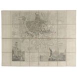
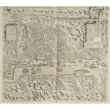
Rome. Feltrini (Domenico), Pianta di Roma publicata nell'anno MDCCCLXVII da Luigi Piale, published
Rome. Feltrini (Domenico), Pianta di Roma publicata nell'anno MDCCCLXVII da Luigi Piale, published Rome, 1867, engraved map of Rome, sectionalised...
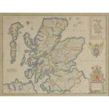
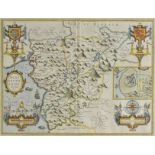
*Scotland. Jansson (Jan), Scotia Regnum, published Amsterdam, circa 1650, engraved map with contemporary outline colouring, inset map of the Orkne...
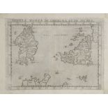
Scotland. Schenk (Petrus & Valk Gerard), Tabula Leogi et Haraiae ac Skiae vel Skiane Insularum,
Scotland. Schenk (Petrus & Valk Gerard), Tabula Leogi et Haraiae ac Skiae vel Skiane Insularum, published Amsterdam, circa 1705, engraved map with...
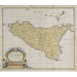
Sicily. Homann (Johann Baptist, heirs of), Regni & Insulae Siciliae tabula geographica, 1747, hand
Sicily. Homann (Johann Baptist, heirs of), Regni & Insulae Siciliae tabula geographica, 1747, hand coloured engraved map, some tape staining large...
Sicily. Ruscelli (Girolamo), Tavuola nuova di Sardigna et di Sicilia, published Venice, circa
Sicily. Ruscelli (Girolamo), Tavuola nuova di Sardigna et di Sicilia, published Venice, circa 1574, uncoloured engraved map, 190 x 255 mm, Italian...
South America. Blaeu (Johannes), Chili [and] Guiana sive Amazonum regio, published Amsterdam,
South America. Blaeu (Johannes), Chili [and] Guiana sive Amazonum regio, published Amsterdam, circa 1648, two engraved maps with contemporary outl...
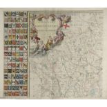
![Southern Counties. Morden (Robert), A collection of seventeen maps, [1695 or later], engraved](https://portal-images.azureedge.net/auctions-2017/srdom10087/images/a82f6b40-0abe-4ac3-80d1-b31c74db6bdd.jpg?w=155&h=155)
Southern Counties. Morden (Robert), A collection of seventeen maps, [1695 or later], engraved
Southern Counties. Morden (Robert), A collection of seventeen maps, [1695 or later], engraved maps, several with hand colouring, some duplicates, ...
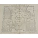
Spain & Portugal. Munster (Sebastian), Tabula Europae II, circa 1545, uncoloured woodblock map on
Spain & Portugal. Munster (Sebastian), Tabula Europae II, circa 1545, uncoloured woodblock map on a trapezoidal projection, slight staining to m...
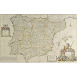
*Spain & Portugal. Moll (Herman), A New and Exact Map of Spain & Portugal Divided into its Kingdoms and Principalities &c. published J. & T. Bowle...
Spain. Blaeu (Johannes), Gallaecia Regnum, Navarra Regnum, Biscaia et Guipuscoa Cantabria veteris
Spain. Blaeu (Johannes), Gallaecia Regnum, Navarra Regnum, Biscaia et Guipuscoa Cantabria veteris pars, Legionis Regnum et Asturiarum Principatus,...