Filtered by:
- Sale Section,
- Category
- List
- Grid
A subscription to the Price Guide is required to view results for auctions ten days or older. Click here for more information
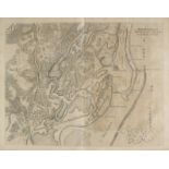

Barlaeus (Caspar). Rerum per Octennium in Brasilia et alibi nuper gestarum...., 1st edition, published Joan Blaeu, Amsterdam, 1647, title page tor...
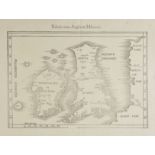
![Greece. Atlas van Morea..., getekend door F[ranciscus] J[ohannes] Boonzaajer, circa 1810, manuscript](https://portal-images.azureedge.net/auctions-2017/srdom10087/images/b4b51ae7-a2fe-440a-ab9e-c1252a8991a2.jpg?w=155&h=155)
Greece. Atlas van Morea..., getekend door F[ranciscus] J[ohannes] Boonzaajer, circa 1810, manuscript
Greece. Atlas van Morea..., getekend door F[ranciscus] J[ohannes] Boonzaajer, circa 1810, manuscript atlas with 1 general double-page map and 40 ...
Hall (Sidney & Hughes William). General Atlas of the World..., published Edinburgh, Adam & Charles
Hall (Sidney & Hughes William). General Atlas of the World..., published Edinburgh, Adam & Charles Black, 1856, title page a little spotted, seven...
Lyon (Captain G.F.). A Brief Narrative of an Unsuccessful Attempt to reach Repulse Bay, through
Lyon (Captain G.F.). A Brief Narrative of an Unsuccessful Attempt to reach Repulse Bay, through Sir Thomas Rowe's "Welcome," in His Majesty's Ship...
Santini (P. Francois). Atlas Universel dress‚ sur les Meilleures cartes modernes, 2 volumes, published Venice, 1784, decorative engraved title pag...
Boswell (Henry). Historical Descriptions of New and Elegant Picturesque Views of the Antiquities
Boswell (Henry). Historical Descriptions of New and Elegant Picturesque Views of the Antiquities of England and Wales, London: Alex Hogg, [1786], ...
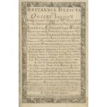
Bowen (Emmanuel). Britannia Depicta or Ogilby Improv'd being a correct coppy of Mr Ogilby's actual
Bowen (Emmanuel). Britannia Depicta or Ogilby Improv'd being a correct coppy of Mr Ogilby's actual survey of all ye Direct & Principal cross roads...
Burlington (Charles, and others). The Modern Universal British Traveller; or, a New, Complete and
Burlington (Charles, and others). The Modern Universal British Traveller; or, a New, Complete and Accurate Tour throught England, Wales, Scotland,...
Cary (John). Cary's New and Correct English Atlas: Being a new set of County Maps from actual
Cary (John). Cary's New and Correct English Atlas: Being a new set of County Maps from actual surveys..., 1st edition, published 1787, title, dedi...
Cruchley (G.F., publisher). Cruchley's County Atlas of England & Wales shewing all the Railways &
Cruchley (G.F., publisher). Cruchley's County Atlas of England & Wales shewing all the Railways & Stations..., [1868], calligraphic title page and...
Lewis (Samuel). [Atlas volume to the Topogaphical Dictionary], circa 1840, lacking titles and
Lewis (Samuel). [Atlas volume to the Topogaphical Dictionary], circa 1840, lacking titles and preliminaries, forty-five uncoloured engraved maps, ...
Whittaker (G. & W. B. publishers). The Travellers Pocket Atlas consisting of a complete set of
Whittaker (G. & W. B. publishers). The Travellers Pocket Atlas consisting of a complete set of County Maps for England & Wales, 1823, calligaphic ...
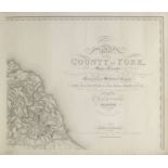
Blaeu (Johannes), Ducatus Eboracensis Anglice York Shire, Ducatus Eboracensis pars Occidentalis; The
Blaeu (Johannes), Ducatus Eboracensis Anglice York Shire, Ducatus Eboracensis pars Occidentalis; The West Riding of Yorkshire, Ducatus Eboracensis...
Bowen (Emanuel), An Accurate Map of the County of York divided into its Wapontakes, drawn from
Bowen (Emanuel), An Accurate Map of the County of York divided into its Wapontakes, drawn from surveys with various improvements..., published J &...
Bryant (A.), Map of the East Riding of Yorkshire from actual survey..., in the years 1827 & 1828,
Bryant (A.), Map of the East Riding of Yorkshire from actual survey..., in the years 1827 & 1828, published A. Bryant 1829, large scale uncoloured...
Clarke (James). A Survey of the Lakes of Cumberland, Westmorland and Lancashire: Together with an
Clarke (James). A Survey of the Lakes of Cumberland, Westmorland and Lancashire: Together with an Account, Historical, Topographical and Descripti...
Clarke (James). A Survey of the Lakes of Cumberland, Westmorland and Lancashire: Together with an
Clarke (James). A Survey of the Lakes of Cumberland, Westmorland and Lancashire: Together with an Account, Historical, Topographical and Descripti...
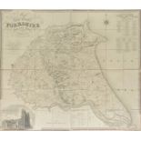
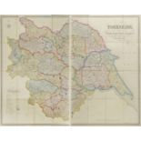
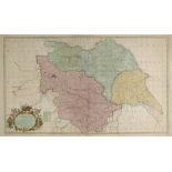
Greenwood (C.), Map of the County of York, made on the Basis of Triangles in the County, determined by Lieut. Col. Wm. Mudge, Royal Art. F.R.S. an...
Hobson (William Colling), This Map of Yorkshire is most Respectfully dedicated to the Nobility,
Hobson (William Colling), This Map of Yorkshire is most Respectfully dedicated to the Nobility, Clergy, Gentry, Landowners and Manufacturers of th...
Hobson (William Colling). This Map of Yorkshire is most respectfully dedicated to the Nobility,
Hobson (William Colling). This Map of Yorkshire is most respectfully dedicated to the Nobility, Clergy, Gentry, Landowners and Manufacturers of th...
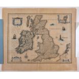
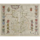
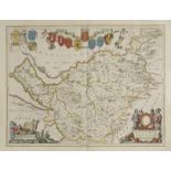
![Morden (Robert), The West Riding of Yorkshire,The East Riding of Yorkshire [and] The North Riding of](https://portal-images.azureedge.net/auctions-2017/srdom10087/images/66f9bd66-18a7-40c5-e028-16f0c35f9181.jpg?w=155&h=155)
Morden (Robert), The West Riding of Yorkshire,The East Riding of Yorkshire [and] The North Riding of
Morden (Robert), The West Riding of Yorkshire,The East Riding of Yorkshire [and] The North Riding of Yorshire, [1695 or later], together three han...
Overton (Philip & Bowles Thomas, publishers), A new map of the county of York laid down from an
Overton (Philip & Bowles Thomas, publishers), A new map of the county of York laid down from an actual survey wherein is included not only all Tow...
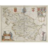
Saxton (Christopher & Hole WIlliam), Eboracensis comitatus pars Occidentalis vulgo West Riding,
Saxton (Christopher & Hole WIlliam), Eboracensis comitatus pars Occidentalis vulgo West Riding, Eboracensis comitatus pars Septentrionalis vulgo N...
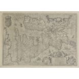
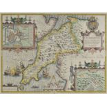
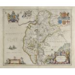
![Saxton (Christopher & Webb William), [Yorkshire, circa 1642], untitled hand coloured map engraved by](https://portal-images.azureedge.net/auctions-2017/srdom10087/images/19564b60-0274-4c96-be2b-9d45112103f7.jpg?w=155&h=155)
Saxton (Christopher & Webb William), [Yorkshire, circa 1642], untitled hand coloured map engraved by
Saxton (Christopher & Webb William), [Yorkshire, circa 1642], untitled hand coloured map engraved by Augustus Ryther, on two conjoined sheets, ins...
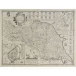
Speed (John), The North and East Ridins of Yorkshire, 1st edition, published John Sudbury & George
Speed (John), The North and East Ridins of Yorkshire, 1st edition, published John Sudbury & George Humble, [1611], uncoloured engraved map, inset ...
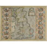
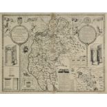
![Speed (John), York Shire, published John Sudbury & George Humble, [1627], hand coloured engraved](https://portal-images.azureedge.net/auctions-2017/srdom10087/images/0e411551-97d7-4030-b27a-fc8fe5898c60.jpg?w=155&h=155)
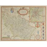
Speed (John), York Shire, published John Sudbury & George Humble, [1627], hand coloured engraved
Speed (John), York Shire, published John Sudbury & George Humble, [1627], hand coloured engraved map, split at base of central fold, repaired on v...
Speed (John), The West Ridinge of Yorkshyre with the most famous and fayre Citie Yorke described,
Speed (John), The West Ridinge of Yorkshyre with the most famous and fayre Citie Yorke described, published C.Dicey & Co., circa 1770, hand colour...
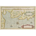
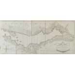
Waghenaer (Lucas van), Beschryvinghe vande zee custen van Engelandt tusschen Blargneii en Scharenburch..., circa 1583, hand coloured sea chart ori...
Austria. Ortelius (Abraham), Austriae descrip. per Wolfgangum Lazium, [1612], uncoloured engraved
Austria. Ortelius (Abraham), Austriae descrip. per Wolfgangum Lazium, [1612], uncoloured engraved map, small worm hole to central fold, 350 x 485 ...
Azores. Ortelius (Abraham), A‡ores Insulae, [1592 - 1612], uncoloured engraved map, large strapwork cartouche, 330 x 465 mm, Latin text on verso M...
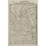
![Bill (John). Mountgomerieshire [and] Brecknockshire, [1626], two uncoloured engraved maps, some](https://portal-images.azureedge.net/auctions-2017/srdom10087/images/a93dfe00-661b-4b03-d9cc-bf48e5bf0242.jpg?w=155&h=155)
Bill (John). Mountgomerieshire [and] Brecknockshire, [1626], two uncoloured engraved maps, some
Bill (John). Mountgomerieshire [and] Brecknockshire, [1626], two uncoloured engraved maps, some staining and dust soiling to margins, one small ru...
Blaeu (Johannes). Comitatus Salopiensis Anglice Shrop Shire, Staffordiensis comitatus vulgo Stafford
Blaeu (Johannes). Comitatus Salopiensis Anglice Shrop Shire, Staffordiensis comitatus vulgo Stafford Shire [and] Herefordia comitatus. Hereford-sh...
Bowen (Emanuel & Owen John). A collection of thirty-one maps originally published in 'Britannia
Bowen (Emanuel & Owen John). A collection of thirty-one maps originally published in 'Britannia Depicta', [1720 or later], thirty-one uncoloured e...
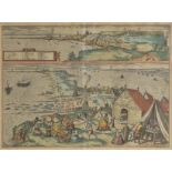
![*Braun (Georg, and Hogenberg, Franz). Penigk, Bardum Pomeraniae, Misena Hermun Durorum urbs [and]](https://portal-images.azureedge.net/auctions-2017/srdom10087/images/09465cfc-ff3a-44bc-89f0-29c21770e924.jpg?w=155&h=155)
*Braun (Georg, and Hogenberg, Franz). Penigk, Bardum Pomeraniae, Misena Hermun Durorum urbs [and]
*Braun (Georg, and Hogenberg, Franz). Penigk, Bardum Pomeraniae, Misena Hermun Durorum urbs [and] Ober Wesell/Boppart, [1590 or later], together f...
*Braun (Georg, and Hogenberg, Franz). Embdena. Embden urbs Frisiae orientalis primaria, [1584 or
*Braun (Georg, and Hogenberg, Franz). Embdena. Embden urbs Frisiae orientalis primaria, [1584 or later], hand coloured enrgaved town plan of town ...
British county maps. A mixed collection of seven county and regional maps, 17th & 18th century,
British county maps. A mixed collection of seven county and regional maps, 17th & 18th century, engraved county maps by Saxton/Kip, Morden, Blaeu ...
British county maps. A mixed collection of approximately 220 British county maps, 17th - 19th
British county maps. A mixed collection of approximately 220 British county maps, 17th - 19th century, engraved maps, many with hand colouring, wi...
British county maps. A mixed collection of approximately 400 maps, mostly 19th century, engraved
British county maps. A mixed collection of approximately 400 maps, mostly 19th century, engraved county and regional maps, town plans and road map...
British Islands. Blaeu (Johannes), Sarnia Insula vulgo Garnsey et Insula Caesarea vernacule Jarsey, published Amsterdam, circa 1648, engraved map ...
British Isles. Blaeu (Johannes), Magnae Britanniae et Hiberniae tabula, published Amsterdam, circa
British Isles. Blaeu (Johannes), Magnae Britanniae et Hiberniae tabula, published Amsterdam, circa 1650, engraved map with sparse outline colourin...
British Isles. Munster Sebastian & Petri Heinrich), Beschzeibrung Engellants und Schottlandts,
British Isles. Munster Sebastian & Petri Heinrich), Beschzeibrung Engellants und Schottlandts, published Basle, [1578 or later], uncoloured woodbl...
British Isles. Porcacchi (Tomaso), Inghilterra, circa 1572, engraved map orientated to the east,
British Isles. Porcacchi (Tomaso), Inghilterra, circa 1572, engraved map orientated to the east, pale hand colouring, 110 x 150 mm, polyglot text ...
British Isles. Custodis (David), Angliae Scotiae et Hiberniae sive Britannicarum Insularum, published Frankfurt, circa 1627, uncoloured engraved m...
British Isles. Jansson (Jan), Angliae, Scotiae et Hiberniae, sive Britannicar: Insularum descriptio,
British Isles. Jansson (Jan), Angliae, Scotiae et Hiberniae, sive Britannicar: Insularum descriptio, Amstelodami Ioannes Janssonius Anno. 1621, un...
British Isles. Speed (John), Britain as it was devided in the tyme of the Englishe Saxona especially
British Isles. Speed (John), Britain as it was devided in the tyme of the Englishe Saxona especially during their Heptarchy, published John Sudbur...
British Isles. Fries (Martin, Waldeseemuller Martin), Tabula nova Angliae & Hiberniae, published
British Isles. Fries (Martin, Waldeseemuller Martin), Tabula nova Angliae & Hiberniae, published Vienne [1541], uncoloured woodcut map, a reductio...
British Isles. De L'Isle (Guillaume), Les Isles Britanniques ou sont le Rme. d'Angleterre tir‚ de
British Isles. De L'Isle (Guillaume), Les Isles Britanniques ou sont le Rme. d'Angleterre tir‚ de Sped celuy d'Ecosse tir‚ de Th. Pont &c. et celu...
British Isles. A mixed collection of six maps, 17th & 18th century, including Merian (Matthaus),
British Isles. A mixed collection of six maps, 17th & 18th century, including Merian (Matthaus), Magnae Britanniae et Hiberniae tabulae die Britan...
![British Isles. Gastaldi (Giacomo), Tabula Europae I, [1548], uncoloured Ptolemaic map with](https://portal-images.azureedge.net/auctions-2017/srdom10087/images/04b2ad50-4ffa-40c0-db99-7052017bf1f4.jpg?w=155&h=155)
British Isles. Gastaldi (Giacomo), Tabula Europae I, [1548], uncoloured Ptolemaic map with decorative vignettes to vertical margins, some staining...
Buckinghamshire. Buckingham both Shyre and Shire towne describ., 1st edition, published George
Buckinghamshire. Buckingham both Shyre and Shire towne describ., 1st edition, published George Humble. circa 1611, uncoloured engraved map, inset ...
*Cadiz. Braun (George and Hogenberg Frans), La puy Noble y Muy Leal Civdas de Cadiz [on sheet
*Cadiz. Braun (George and Hogenberg Frans), La puy Noble y Muy Leal Civdas de Cadiz [on sheet with] Almodrava de Caditz sive Thynnorum Piscatio ap...
Cambridgeshire. Blaeu (Johannes), Cantabrigiensis comitatus Cambridge Shire, published Amsterdam,
Cambridgeshire. Blaeu (Johannes), Cantabrigiensis comitatus Cambridge Shire, published Amsterdam, circa 1648, engraved map with contemporary outli...
*Carnarvonshire. Speed (John), Caerarvon both Shyre and Shire-towne with the ancient Citie Bangor
*Carnarvonshire. Speed (John), Caerarvon both Shyre and Shire-towne with the ancient Citie Bangor described, 1st edition, published John Sudbury &...
Cary (John). Cary's Traveller's Companion, or a Delineation of the Turnpike Roads of England and
Cary (John). Cary's Traveller's Companion, or a Delineation of the Turnpike Roads of England and Wales..., 1791, calligraphic title, advertisement...
*Cheshire. Bowen (Emanuel), An Accurate Map of the County Palatine of Chester divided into its
*Cheshire. Bowen (Emanuel), An Accurate Map of the County Palatine of Chester divided into its Hundreds..., published T. & J. Bowles and Robert Sa...
Cheshire. Blaeu (Johannes), Cestria comitatus palatinus, published Amsterdam, circa 1648, engraved
Cheshire. Blaeu (Johannes), Cestria comitatus palatinus, published Amsterdam, circa 1648, engraved map with bright contemporary outline colouring,...
Cumberland, Northumberland & Westmoreland. Blaeu (Johannes), Cumbria vulgo Cumberland, Comitatus
Cumberland, Northumberland & Westmoreland. Blaeu (Johannes), Cumbria vulgo Cumberland, Comitatus Northumbria vernacule Northumberland [and] Westmo...
Cumberland. Speed (John), Cumberland and the ancient citie Carlile described with many memorable
Cumberland. Speed (John), Cumberland and the ancient citie Carlile described with many memorable antiquities therin found observed, 1st edition, p...
![Cyprus. Magini (Giovanni Antonio), Cypri Insula, published Venice, [1596 or later], uncoloured](https://portal-images.azureedge.net/auctions-2017/srdom10087/images/8f384867-7290-400e-979b-04bbde07b0b6.jpg?w=155&h=155)
Cyprus. Magini (Giovanni Antonio), Cypri Insula, published Venice, [1596 or later], uncoloured
Cyprus. Magini (Giovanni Antonio), Cypri Insula, published Venice, [1596 or later], uncoloured map, engraved by G.Porro, Italian text below and on...