Refine your search
Sale Section
Estimate
Category
- Books & Periodicals (356)
- Maps (169)
- Prints (70)
- Metalware (15)
- Tools (13)
- Furniture (12)
- Watercolours (6)
- Collectables (5)
- Vintage Fashion (5)
- Ceramics (4)
- Photographs (3)
- Watches & Watch accessories (2)
- Arms, Armour & Militaria (1)
- Coins (1)
- Drawings & Pastels (1)
- Models, Toys, Dolls & Games (1)
- Textiles (1)
Filtered by:
- Creator / Brand
- List
- Grid
A subscription to the Price Guide is required to view results for auctions ten days or older. Click here for more information

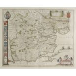
Thoresby (Ralph). Ducatus Leodiensis: Or, the Topography of the Ancient and Populous Town and Parish
Thoresby (Ralph). Ducatus Leodiensis: Or, the Topography of the Ancient and Populous Town and Parish of Leedes, and Parts Adjacent in the West-Rid...
Turner (J.M.W. & John Buckler). A Series of Views of the Most Picturesque Scenes in Richmondshire,
Turner (J.M.W. & John Buckler). A Series of Views of the Most Picturesque Scenes in Richmondshire, From Drawings by J.M.W. Turner and John Buckler...
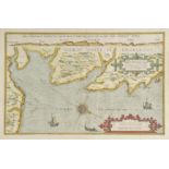
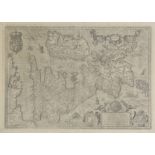
Waghenaer (Lucas van), Beschryvinghe vande zee custen van Engelandt tusschen Blargneii en Scharenburch..., circa 1583, hand coloured sea chart ori...
Worsfold (John Napper). History of Haddlesey: Its Past and Present, 1894, black & white frontispiece, edges untrimmed, armorial bookplate of Lord ...
Austria. Ortelius (Abraham), Austriae descrip. per Wolfgangum Lazium, [1612], uncoloured engraved
Austria. Ortelius (Abraham), Austriae descrip. per Wolfgangum Lazium, [1612], uncoloured engraved map, small worm hole to central fold, 350 x 485 ...
Azores. Ortelius (Abraham), A‡ores Insulae, [1592 - 1612], uncoloured engraved map, large strapwork cartouche, 330 x 465 mm, Latin text on verso M...
![Bill (John). Mountgomerieshire [and] Brecknockshire, [1626], two uncoloured engraved maps, some](https://portal-images.azureedge.net/auctions-2017/srdom10087/images/a93dfe00-661b-4b03-d9cc-bf48e5bf0242.jpg?w=155&h=155)
Bill (John). Mountgomerieshire [and] Brecknockshire, [1626], two uncoloured engraved maps, some
Bill (John). Mountgomerieshire [and] Brecknockshire, [1626], two uncoloured engraved maps, some staining and dust soiling to margins, one small ru...
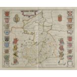
Blaeu (Johannes). Comitatus Salopiensis Anglice Shrop Shire, Staffordiensis comitatus vulgo Stafford
Blaeu (Johannes). Comitatus Salopiensis Anglice Shrop Shire, Staffordiensis comitatus vulgo Stafford Shire [and] Herefordia comitatus. Hereford-sh...
Bowen (Emanuel & Owen John). A collection of thirty-one maps originally published in 'Britannia
Bowen (Emanuel & Owen John). A collection of thirty-one maps originally published in 'Britannia Depicta', [1720 or later], thirty-one uncoloured e...
![*Braun (Georg, and Hogenberg, Franz). Penigk, Bardum Pomeraniae, Misena Hermun Durorum urbs [and]](https://portal-images.azureedge.net/auctions-2017/srdom10087/images/09465cfc-ff3a-44bc-89f0-29c21770e924.jpg?w=155&h=155)
*Braun (Georg, and Hogenberg, Franz). Penigk, Bardum Pomeraniae, Misena Hermun Durorum urbs [and]
*Braun (Georg, and Hogenberg, Franz). Penigk, Bardum Pomeraniae, Misena Hermun Durorum urbs [and] Ober Wesell/Boppart, [1590 or later], together f...
*Braun (Georg, and Hogenberg, Franz). Embdena. Embden urbs Frisiae orientalis primaria, [1584 or
*Braun (Georg, and Hogenberg, Franz). Embdena. Embden urbs Frisiae orientalis primaria, [1584 or later], hand coloured enrgaved town plan of town ...
British county maps. A mixed collection of seven county and regional maps, 17th & 18th century,
British county maps. A mixed collection of seven county and regional maps, 17th & 18th century, engraved county maps by Saxton/Kip, Morden, Blaeu ...
British county maps. A mixed collection of approximately 220 British county maps, 17th - 19th
British county maps. A mixed collection of approximately 220 British county maps, 17th - 19th century, engraved maps, many with hand colouring, wi...
British county maps. A mixed collection of approximately 400 maps, mostly 19th century, engraved
British county maps. A mixed collection of approximately 400 maps, mostly 19th century, engraved county and regional maps, town plans and road map...
British Islands. Blaeu (Johannes), Sarnia Insula vulgo Garnsey et Insula Caesarea vernacule Jarsey, published Amsterdam, circa 1648, engraved map ...
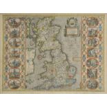
British Isles. Blaeu (Johannes), Magnae Britanniae et Hiberniae tabula, published Amsterdam, circa
British Isles. Blaeu (Johannes), Magnae Britanniae et Hiberniae tabula, published Amsterdam, circa 1650, engraved map with sparse outline colourin...
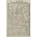
British Isles. Munster Sebastian & Petri Heinrich), Beschzeibrung Engellants und Schottlandts,
British Isles. Munster Sebastian & Petri Heinrich), Beschzeibrung Engellants und Schottlandts, published Basle, [1578 or later], uncoloured woodbl...
British Isles. Porcacchi (Tomaso), Inghilterra, circa 1572, engraved map orientated to the east,
British Isles. Porcacchi (Tomaso), Inghilterra, circa 1572, engraved map orientated to the east, pale hand colouring, 110 x 150 mm, polyglot text ...
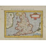
British Isles. Custodis (David), Angliae Scotiae et Hiberniae sive Britannicarum Insularum, published Frankfurt, circa 1627, uncoloured engraved m...
British Isles. Jansson (Jan), Angliae, Scotiae et Hiberniae, sive Britannicar: Insularum descriptio,
British Isles. Jansson (Jan), Angliae, Scotiae et Hiberniae, sive Britannicar: Insularum descriptio, Amstelodami Ioannes Janssonius Anno. 1621, un...
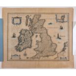
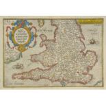
British Isles. Speed (John), Britain as it was devided in the tyme of the Englishe Saxona especially
British Isles. Speed (John), Britain as it was devided in the tyme of the Englishe Saxona especially during their Heptarchy, published John Sudbur...
British Isles. Fries (Martin, Waldeseemuller Martin), Tabula nova Angliae & Hiberniae, published
British Isles. Fries (Martin, Waldeseemuller Martin), Tabula nova Angliae & Hiberniae, published Vienne [1541], uncoloured woodcut map, a reductio...
British Isles. De L'Isle (Guillaume), Les Isles Britanniques ou sont le Rme. d'Angleterre tir‚ de
British Isles. De L'Isle (Guillaume), Les Isles Britanniques ou sont le Rme. d'Angleterre tir‚ de Sped celuy d'Ecosse tir‚ de Th. Pont &c. et celu...
British Isles. A mixed collection of six maps, 17th & 18th century, including Merian (Matthaus),
British Isles. A mixed collection of six maps, 17th & 18th century, including Merian (Matthaus), Magnae Britanniae et Hiberniae tabulae die Britan...
![British Isles. Gastaldi (Giacomo), Tabula Europae I, [1548], uncoloured Ptolemaic map with](https://portal-images.azureedge.net/auctions-2017/srdom10087/images/04b2ad50-4ffa-40c0-db99-7052017bf1f4.jpg?w=155&h=155)
British Isles. Gastaldi (Giacomo), Tabula Europae I, [1548], uncoloured Ptolemaic map with decorative vignettes to vertical margins, some staining...
Buckinghamshire. Buckingham both Shyre and Shire towne describ., 1st edition, published George
Buckinghamshire. Buckingham both Shyre and Shire towne describ., 1st edition, published George Humble. circa 1611, uncoloured engraved map, inset ...
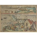
*Cadiz. Braun (George and Hogenberg Frans), La puy Noble y Muy Leal Civdas de Cadiz [on sheet
*Cadiz. Braun (George and Hogenberg Frans), La puy Noble y Muy Leal Civdas de Cadiz [on sheet with] Almodrava de Caditz sive Thynnorum Piscatio ap...
Cambridgeshire. Blaeu (Johannes), Cantabrigiensis comitatus Cambridge Shire, published Amsterdam,
Cambridgeshire. Blaeu (Johannes), Cantabrigiensis comitatus Cambridge Shire, published Amsterdam, circa 1648, engraved map with contemporary outli...
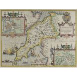
*Carnarvonshire. Speed (John), Caerarvon both Shyre and Shire-towne with the ancient Citie Bangor
*Carnarvonshire. Speed (John), Caerarvon both Shyre and Shire-towne with the ancient Citie Bangor described, 1st edition, published John Sudbury &...
Cary (John). Cary's Traveller's Companion, or a Delineation of the Turnpike Roads of England and
Cary (John). Cary's Traveller's Companion, or a Delineation of the Turnpike Roads of England and Wales..., 1791, calligraphic title, advertisement...
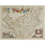
*Cheshire. Bowen (Emanuel), An Accurate Map of the County Palatine of Chester divided into its
*Cheshire. Bowen (Emanuel), An Accurate Map of the County Palatine of Chester divided into its Hundreds..., published T. & J. Bowles and Robert Sa...
Cheshire. Blaeu (Johannes), Cestria comitatus palatinus, published Amsterdam, circa 1648, engraved
Cheshire. Blaeu (Johannes), Cestria comitatus palatinus, published Amsterdam, circa 1648, engraved map with bright contemporary outline colouring,...
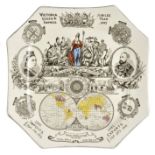
*Commemorative china. Victoria, Queen & Empress, Jubilee Year 1887, octagonal plate illustrated with
*Commemorative china. Victoria, Queen & Empress, Jubilee Year 1887, octagonal plate illustrated with transfer illustrations of the queen and the P...
Cumberland, Northumberland & Westmoreland. Blaeu (Johannes), Cumbria vulgo Cumberland, Comitatus
Cumberland, Northumberland & Westmoreland. Blaeu (Johannes), Cumbria vulgo Cumberland, Comitatus Northumbria vernacule Northumberland [and] Westmo...
Cumberland. Speed (John), Cumberland and the ancient citie Carlile described with many memorable
Cumberland. Speed (John), Cumberland and the ancient citie Carlile described with many memorable antiquities therin found observed, 1st edition, p...
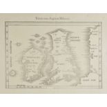
![Cyprus. Magini (Giovanni Antonio), Cypri Insula, published Venice, [1596 or later], uncoloured](https://portal-images.azureedge.net/auctions-2017/srdom10087/images/8f384867-7290-400e-979b-04bbde07b0b6.jpg?w=155&h=155)
Cyprus. Magini (Giovanni Antonio), Cypri Insula, published Venice, [1596 or later], uncoloured
Cyprus. Magini (Giovanni Antonio), Cypri Insula, published Venice, [1596 or later], uncoloured map, engraved by G.Porro, Italian text below and on...
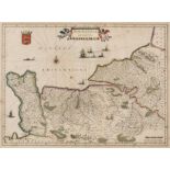
![Denmark. Ortelius (Abraham), Daniae Regni Typus [on sheet with] Oldenburg Comit., Frisia](https://portal-images.azureedge.net/auctions-2017/srdom10087/images/e9e89bb4-ca1d-4071-bbe2-b052ee732a4b.jpg?w=155&h=155)
Denmark. Ortelius (Abraham), Daniae Regni Typus [on sheet with] Oldenburg Comit., Frisia Orientalis [and] Frisia Occidentalis, [1592], three uncol...
Devon. Blaeu (Johannes), Devonia vulgo Devon-shire, published Amsterdam, circa 1648, engraved map
Devon. Blaeu (Johannes), Devonia vulgo Devon-shire, published Amsterdam, circa 1648, engraved map with contemporary outline colouring, some staini...
Devon. Morden (Robert), Devonshire (1695 or later), uncoloued engraved map, 365 x 420 mm, together
Devon. Morden (Robert), Devonshire (1695 or later), uncoloued engraved map, 365 x 420 mm, together with Van den Keere (Pieter), Devon-shire, circa...
Dorset. Blaeu (Johannes), Comitatus Dorcestria sive Dorsettia vulgo Anglice Dorset Shire, published Amsterdam, circa 1648, engraved map with conte...
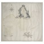
![*Drayton (Michael). Untitled map of South Wales and North Devon and Somerset, [1612 - 1622],](https://portal-images.azureedge.net/auctions-2017/srdom10087/images/7f7252d7-ebb8-41bd-99c8-e8e4d9c829bf.jpg?w=155&h=155)
*Drayton (Michael). Untitled map of South Wales and North Devon and Somerset, [1612 - 1622],
*Drayton (Michael). Untitled map of South Wales and North Devon and Somerset, [1612 - 1622], uncoloured engraved allegorical map, 250 x 330 mm, mo...
East Anglia. Blaeu (Johannes), Suffolcia vernacule Suffolke, Nortfolcia Norfolk [and] Essexia
East Anglia. Blaeu (Johannes), Suffolcia vernacule Suffolke, Nortfolcia Norfolk [and] Essexia comitatus, published Amsterdam, circa 1648, together...
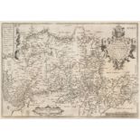
Eastern Europe. Ortelius (Abraham), Bavariae olim..., Regni Bohemiae descriptio, Silesiae Typus..., [and] Moraviae quae olim marcomannorum..., [15...
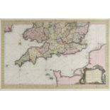
England & Wales. Bertius (Petrus), Anglia, Cornub. Devonia Somerset etc., Warwicum Northapton
England & Wales. Bertius (Petrus), Anglia, Cornub. Devonia Somerset etc., Warwicum Northapton Hunting etc., Westmorlad. Lancastri Cestria etc.,Ebo...
England & Wales. Quad (Matthias), Angliae regni florentissimi nova descriptio auctore Humeredo Lhuyd
England & Wales. Quad (Matthias), Angliae regni florentissimi nova descriptio auctore Humeredo Lhuyd Denbygiense, published Cologne, [1592 or late...
England & Wales. Mercator (Gerard & Hondius Jodocus), Anglia Regnum, circa 1628, engraved map with
England & Wales. Mercator (Gerard & Hondius Jodocus), Anglia Regnum, circa 1628, engraved map with contemporary hand colouring, central fold stren...
England & Wales. Bellin (Jacques Nicolas), Carte R‚duite des Isles Britanniques en cinq feuilles...,
England & Wales. Bellin (Jacques Nicolas), Carte R‚duite des Isles Britanniques en cinq feuilles..., Premiere Feuille [together with] Carte R‚duit...
England & Wales. A collection of seventy maps, 19th century, engraved and lithographic maps, with
England & Wales. A collection of seventy maps, 19th century, engraved and lithographic maps, with examples by Stanford, Betts, Stulpnagel, Weller,...
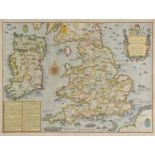
England, Wales & Ireland. Speed (John), The Invasions of England and Ireland with al their Civill
England, Wales & Ireland. Speed (John), The Invasions of England and Ireland with al their Civill Wars since the Conquest, published George Humble...
Essex. Blaeu (Johannes), Essexia comitatus, published Amsterdam, circa 1648, engraved map with
Essex. Blaeu (Johannes), Essexia comitatus, published Amsterdam, circa 1648, engraved map with contemporary outline colouring, slight showthrough,...
Essex. Speed (John), Essex devided into Hundreds with the most antient and fayre towne Colchester
Essex. Speed (John), Essex devided into Hundreds with the most antient and fayre towne Colchester described and other memorable monuments observed...
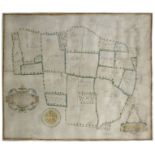
Estate Plan. Whistpaine (Robert), The survey of farme lying in the parish of Tollesbury, in the
Estate Plan. Whistpaine (Robert), The survey of farme lying in the parish of Tollesbury, in the countye of Essex and of late belonging to Henry Sm...
Estate Plan. Harris (John, surveyor), To the Right Honorable Edward Earl of Oxford and Mortimer
Estate Plan. Harris (John, surveyor), To the Right Honorable Edward Earl of Oxford and Mortimer and to James King Esq. This Map of the division of...
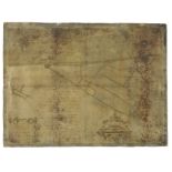
Estate Plan. A Map & Description of the Manor of Walmer lyinge in East Kente with one Tenement one
Estate Plan. A Map & Description of the Manor of Walmer lyinge in East Kente with one Tenement one Parte of Marsh and 16 Peeces of Errable & Past...
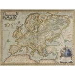
*Europe. Jansson (Jan), Europam sive Celticam veterem sic describere conobar Abrahamus Ortelius, [
*Europe. Jansson (Jan), Europam sive Celticam veterem sic describere conobar Abrahamus Ortelius, [1640 or later], hand coloured engraved map, deco...
France. Ortelius (Abraham), Poictou. Pictonum Vicinarumque regionum fidiss descriptio, [1592],
France. Ortelius (Abraham), Poictou. Pictonum Vicinarumque regionum fidiss descriptio, [1592], uncoloured engraved map of South west France, strap...
France. Ortelius (Abraham), Galliae Regni potentiss: Nova descriptio Ioanne Ioliveto auctore, [
France. Ortelius (Abraham), Galliae Regni potentiss: Nova descriptio Ioanne Ioliveto auctore, [1592 - 1603], uncoloured engraved map, 350 x 500 mm...
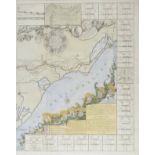
France. Nolin (Jean Baptiste), Le Canal Royal de Languedoc pour la Jonction de L'Ocean et de la
France. Nolin (Jean Baptiste), Le Canal Royal de Languedoc pour la Jonction de L'Ocean et de la Mer Mediterrane....., published Paris, 1697, large...
France. Blaeu (Johannes), Normandia ducatus, Ducatus Turonensis..., Bituricum ducatus Duche de
France. Blaeu (Johannes), Normandia ducatus, Ducatus Turonensis..., Bituricum ducatus Duche de Berri, Nivernium ducatus Gallice Duche de Nevers, U...
Germany. Ortelius (Abraham), Westphaliae totius finitimarumque regionum accurate descriptio,
Germany. Ortelius (Abraham), Westphaliae totius finitimarumque regionum accurate descriptio, Brandeburgensis marchae descriptio, Franciae orientli...