Filtered by:
- Sale Section,
- Creator / Brand
- List
- Grid
A subscription to the Price Guide is required to view results for auctions ten days or older. Click here for more information

Addy (Sidney Oldall). The Hall of Waltheof or the Early Condition and Settlement of Hallamshire,
Addy (Sidney Oldall). The Hall of Waltheof or the Early Condition and Settlement of Hallamshire, published London & Sheffield, 1893, etched plates...
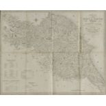
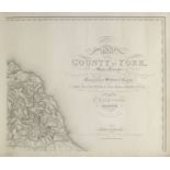
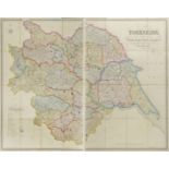
Baines (Edward, publisher), Map of the East & North Ridings of the County of York, Including the
Baines (Edward, publisher), Map of the East & North Ridings of the County of York, Including the latest Improvements, Engraved for the History and...
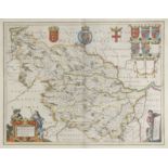
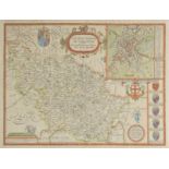
Blaeu (Johannes), Ducatus Eboracensis Anglice York Shire, Ducatus Eboracensis pars Occidentalis; The
Blaeu (Johannes), Ducatus Eboracensis Anglice York Shire, Ducatus Eboracensis pars Occidentalis; The West Riding of Yorkshire, Ducatus Eboracensis...
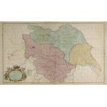
Bowen (Emanuel), An Accurate Map of the County of York divided into its Wapontakes, drawn from
Bowen (Emanuel), An Accurate Map of the County of York divided into its Wapontakes, drawn from surveys with various improvements..., published J &...
Bradford. Ibbestson's Directory of the Borough of Bradford..., published Bradford, 1845, engraved
Bradford. Ibbestson's Directory of the Borough of Bradford..., published Bradford, 1845, engraved frontispiece, trade advertisements at rear, orig...
Browne (John). The History of the Metropolitan Church of St. Peter, York, 2 volumes (text/plates),
Browne (John). The History of the Metropolitan Church of St. Peter, York, 2 volumes (text/plates), 1847, list of subscribers to volume 1, 150 engr...
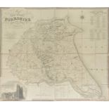
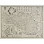
Bryant (A.), Map of the East Riding of Yorkshire from actual survey..., in the years 1827 & 1828,
Bryant (A.), Map of the East Riding of Yorkshire from actual survey..., in the years 1827 & 1828, published A. Bryant 1829, large scale uncoloured...
Burkill (John). Bolton Illustrated: A Series of Views of the Scenery around Bolton Abbey, Wharfdale,
Burkill (John). Bolton Illustrated: A Series of Views of the Scenery around Bolton Abbey, Wharfdale, Yorkshire, the picturesque domain of His Grac...
Clarke (James). A Survey of the Lakes of Cumberland, Westmorland and Lancashire: Together with an
Clarke (James). A Survey of the Lakes of Cumberland, Westmorland and Lancashire: Together with an Account, Historical, Topographical and Descripti...
Clarke (James). A Survey of the Lakes of Cumberland, Westmorland and Lancashire: Together with an
Clarke (James). A Survey of the Lakes of Cumberland, Westmorland and Lancashire: Together with an Account, Historical, Topographical and Descripti...
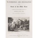
Cuitt (George). Wanderings and Pencillings amongst Ruins of the Olden Time, 1st edition, 1848,
Cuitt (George). Wanderings and Pencillings amongst Ruins of the Olden Time, 1st edition, 1848, seventy-three etched plates including frontispiece ...
Dayes (Edward). The Works of the Late Edward Dayes: Containing an Excursion through the Principal
Dayes (Edward). The Works of the Late Edward Dayes: Containing an Excursion through the Principal Parts of Derbyshire and Yorkshire, with Illustra...
*Estate Plan. A Plan of the Lordship of Rysam Garth in Holderness in the East Ryding of the County
*Estate Plan. A Plan of the Lordship of Rysam Garth in Holderness in the East Ryding of the County of Yorke, copied from an Antient Survey made in...
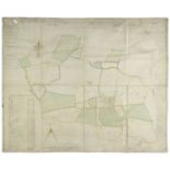
*Estate Plan. A manuscript plan of an estate in the townships of Ecton and Aislaby, Yorkshire
*Estate Plan. A manuscript plan of an estate in the townships of Ecton and Aislaby, Yorkshire North Riding, 1813, by Ralph Burton, pen and ink on...
Gent (Thomas). The Ancient and Modern History of the Loyal Town of Rippon..., 1st edition, York,
Gent (Thomas). The Ancient and Modern History of the Loyal Town of Rippon..., 1st edition, York, 1733, folding woodcut frontispiece, (lined to ver...
Greenwood (C.), Map of the County of York, made on the Basis of Triangles in the County, determined by Lieut. Col. Wm. Mudge, Royal Art. F.R.S. an...
Hall (John George). A History of South Cave and of other Parishes in the East Riding of the County
Hall (John George). A History of South Cave and of other Parishes in the East Riding of the County of York, Hull: Edwin Ombler, 1892, lithograph f...
Hinderwell (Thomas). The History and Antiquities of Scarborough and the Vicinity..., 1st edition,
Hinderwell (Thomas). The History and Antiquities of Scarborough and the Vicinity..., 1st edition, York, 1798, folding engraved map, four engraved...
Hobson (William Colling), This Map of Yorkshire is most Respectfully dedicated to the Nobility,
Hobson (William Colling), This Map of Yorkshire is most Respectfully dedicated to the Nobility, Clergy, Gentry, Landowners and Manufacturers of th...
Hobson (William Colling). This Map of Yorkshire is most respectfully dedicated to the Nobility,
Hobson (William Colling). This Map of Yorkshire is most respectfully dedicated to the Nobility, Clergy, Gentry, Landowners and Manufacturers of th...
Hull. Kyngestone Super Hull Illustrated, 3 volumes, 1885, titles printed in red and black, thirteen black & white plates and plans, text and plat...
[Hunter, Joseph]. Antiquarian notices of Lupset, the Heath, Sharlston, and Ackton, in the County
[Hunter, Joseph]. Antiquarian notices of Lupset, the Heath, Sharlston, and Ackton, in the County of York, [London: Printed by J.B. Nichols and Son...
Hunter (Rev. Joseph). South Yorkshire. The History and Topography of the Deanery of Doncaster in the
Hunter (Rev. Joseph). South Yorkshire. The History and Topography of the Deanery of Doncaster in the Diocese and County of York, 2 volumes, publis...
Kennion (George). The Illustrated Hand-Book for Harrogate, with Excursions in the Neighbourhood..., also, Incorporated by Permission, Observations...
Leeds. A History of the Town and Parish of Leeds, Compiled from Various Authors. To which are added,
Leeds. A History of the Town and Parish of Leeds, Compiled from Various Authors. To which are added, a History of Kirkstall Abbey and a Leeds Dire...
Maude (Thomas). Wensleydale; or, Rural Contemplations: A Poem, 4th edition, Richmond, 1816, engraved
Maude (Thomas). Wensleydale; or, Rural Contemplations: A Poem, 4th edition, Richmond, 1816, engraved frontispiece offset to title, folding pedigre...
McCall (Hardy Bertram). The Early History of Bedale in the North Riding of Yorkshire, 1st edition,
McCall (Hardy Bertram). The Early History of Bedale in the North Riding of Yorkshire, 1st edition, 1907, etched frontispiece, black & white plates...
![Morden (Robert), The West Riding of Yorkshire,The East Riding of Yorkshire [and] The North Riding of](https://portal-images.azureedge.net/auctions-2017/srdom10087/images/66f9bd66-18a7-40c5-e028-16f0c35f9181.jpg?w=155&h=155)
Morden (Robert), The West Riding of Yorkshire,The East Riding of Yorkshire [and] The North Riding of
Morden (Robert), The West Riding of Yorkshire,The East Riding of Yorkshire [and] The North Riding of Yorshire, [1695 or later], together three han...
Overton (Philip & Bowles Thomas, publishers), A new map of the county of York laid down from an
Overton (Philip & Bowles Thomas, publishers), A new map of the county of York laid down from an actual survey wherein is included not only all Tow...
Pennant (Thomas). A Tour from Alston-Moor to Harrowgate and Brimham Crags, 1804, nine engraved
Pennant (Thomas). A Tour from Alston-Moor to Harrowgate and Brimham Crags, 1804, nine engraved plates, occasional light spotting and offsetting, Y...
Purey-Cust (Rev. A.P.). The Heraldry of York Minster: A Key to the History of its Builders and
Purey-Cust (Rev. A.P.). The Heraldry of York Minster: A Key to the History of its Builders and Benefactors. As shewn in the Stained-Glass Windows,...
Saxton (Christopher & Hole WIlliam), Eboracensis comitatus pars Occidentalis vulgo West Riding,
Saxton (Christopher & Hole WIlliam), Eboracensis comitatus pars Occidentalis vulgo West Riding, Eboracensis comitatus pars Septentrionalis vulgo N...
![Saxton (Christopher & Webb William), [Yorkshire, circa 1642], untitled hand coloured map engraved by](https://portal-images.azureedge.net/auctions-2017/srdom10087/images/19564b60-0274-4c96-be2b-9d45112103f7.jpg?w=155&h=155)
Saxton (Christopher & Webb William), [Yorkshire, circa 1642], untitled hand coloured map engraved by
Saxton (Christopher & Webb William), [Yorkshire, circa 1642], untitled hand coloured map engraved by Augustus Ryther, on two conjoined sheets, ins...
Shipton (Ursula, Mother). The Strange and Wonderful History and Prophecies of Mother Shipton,
Shipton (Ursula, Mother). The Strange and Wonderful History and Prophecies of Mother Shipton, printed by J. Kendrew, Collier-gate, York, 1809, 24p...
Speed (John), The North and East Ridins of Yorkshire, 1st edition, published John Sudbury & George
Speed (John), The North and East Ridins of Yorkshire, 1st edition, published John Sudbury & George Humble, [1611], uncoloured engraved map, inset ...
![Speed (John), York Shire, published John Sudbury & George Humble, [1627], hand coloured engraved](https://portal-images.azureedge.net/auctions-2017/srdom10087/images/0e411551-97d7-4030-b27a-fc8fe5898c60.jpg?w=155&h=155)
Speed (John), York Shire, published John Sudbury & George Humble, [1627], hand coloured engraved
Speed (John), York Shire, published John Sudbury & George Humble, [1627], hand coloured engraved map, split at base of central fold, repaired on v...
Speed (John), The West Ridinge of Yorkshyre with the most famous and fayre Citie Yorke described,
Speed (John), The West Ridinge of Yorkshyre with the most famous and fayre Citie Yorke described, published C.Dicey & Co., circa 1770, hand colour...
Storer (J. & H.S.). Delineations, Graphical and Descriptive, of Fountains' Abbey, in the West Riding
Storer (J. & H.S.). Delineations, Graphical and Descriptive, of Fountains' Abbey, in the West Riding of the County of York, with Historical Notice...
Sutcliffe (Halliwell, and Smith, A. Reginald). The Striding Dales, 1st edition, 1929, colour
Sutcliffe (Halliwell, and Smith, A. Reginald). The Striding Dales, 1st edition, 1929, colour plates and black & white illustrations to text, origi...
Thoresby (Ralph). Ducatus Leodiensis: Or, the Topography of the Ancient and Populous Town and Parish
Thoresby (Ralph). Ducatus Leodiensis: Or, the Topography of the Ancient and Populous Town and Parish of Leedes, and Parts Adjacent in the West-Rid...
Turner (J.M.W. & John Buckler). A Series of Views of the Most Picturesque Scenes in Richmondshire,
Turner (J.M.W. & John Buckler). A Series of Views of the Most Picturesque Scenes in Richmondshire, From Drawings by J.M.W. Turner and John Buckler...
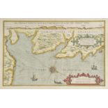
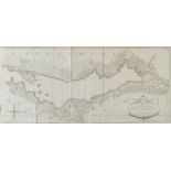
Waghenaer (Lucas van), Beschryvinghe vande zee custen van Engelandt tusschen Blargneii en Scharenburch..., circa 1583, hand coloured sea chart ori...
Worsfold (John Napper). History of Haddlesey: Its Past and Present, 1894, black & white frontispiece, edges untrimmed, armorial bookplate of Lord ...