Filtered by:
- Sale Section,
- Creator / Brand
- List
- Grid
A subscription to the Price Guide is required to view results for auctions ten days or older. Click here for more information
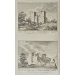

Boswell (Henry). Historical Descriptions of New and Elegant Picturesque Views of the Antiquities
Boswell (Henry). Historical Descriptions of New and Elegant Picturesque Views of the Antiquities of England and Wales, London: Alex Hogg, [1786], ...
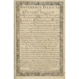
Bowen (Emmanuel). Britannia Depicta or Ogilby Improv'd being a correct coppy of Mr Ogilby's actual
Bowen (Emmanuel). Britannia Depicta or Ogilby Improv'd being a correct coppy of Mr Ogilby's actual survey of all ye Direct & Principal cross roads...
Burlington (Charles, and others). The Modern Universal British Traveller; or, a New, Complete and
Burlington (Charles, and others). The Modern Universal British Traveller; or, a New, Complete and Accurate Tour throught England, Wales, Scotland,...
Cary (John). Cary's New and Correct English Atlas: Being a new set of County Maps from actual
Cary (John). Cary's New and Correct English Atlas: Being a new set of County Maps from actual surveys..., 1st edition, published 1787, title, dedi...
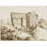
*Cheshire. View of Little Moreton Hall, near Congleton, Cheshire, early-mid 19th century, pen, ink &
*Cheshire. View of Little Moreton Hall, near Congleton, Cheshire, early-mid 19th century, pen, ink & sepia watercolour after the engraved view p...
Clarke (B.). The British Gazetteer, Political Commercial, Ecclesiastical and Historical......,
Clarke (B.). The British Gazetteer, Political Commercial, Ecclesiastical and Historical......, Illustrated by a Full Set of County Maps, 3 volumes...
Cruchley (G.F., publisher). Cruchley's County Atlas of England & Wales shewing all the Railways &
Cruchley (G.F., publisher). Cruchley's County Atlas of England & Wales shewing all the Railways & Stations..., [1868], calligraphic title page and...
Douglas (Thomas, Earl of Selkirk). Observations on the Present State of the Highlands of Scotland,
Douglas (Thomas, Earl of Selkirk). Observations on the Present State of the Highlands of Scotland, with a View of the Causes and Probable Conseque...
Dugdale (William). The Antquities of Warwickshire Illustrated; From Records, Leiger-Books, Manuscripts, Charters, Evidences, Tombes, and Armes, 1s...
Fisher (William Richard). The Forest of Essex: Its History, Laws, Administration and Ancient Customs, and the Wild Deer which Lived in It, 1st edi...
Grose (Francis and Astle, Thomas). The Antiquarian Repertory: a Miscellaneous Assemblage of Topography, History, Biography, Customs, and Manners. ...
Hutchinson (William). The History and Antiquities of the County Palatine of Durham, 3 volumes,
Hutchinson (William). The History and Antiquities of the County Palatine of Durham, 3 volumes, Newcastle and Carlisle, 1785-94, titles with engrav...
Journal of Royal Society of Antiquaries of Ireland, volumes 1-138, a complete run, 1849-2011,
Journal of Royal Society of Antiquaries of Ireland, volumes 1-138, a complete run, 1849-2011, numerous black and white illustrations, all uniform...
Lewis (Samuel). [Atlas volume to the Topogaphical Dictionary], circa 1840, lacking titles and
Lewis (Samuel). [Atlas volume to the Topogaphical Dictionary], circa 1840, lacking titles and preliminaries, forty-five uncoloured engraved maps, ...
Liverpool. Hills (G. H., Surveyor) Liverpool Bay surveyed by the Marine Surveyor of the Mersey Docks
Liverpool. Hills (G. H., Surveyor) Liverpool Bay surveyed by the Marine Surveyor of the Mersey Docks and Harbour Board, 1877. Corrected to 1880. S...
Mackenzie (James). The General Grievances and Oppression of the Isles of Orkney and Shetland,
Mackenzie (James). The General Grievances and Oppression of the Isles of Orkney and Shetland, Edinburgh: Reprinted by Neill & Co., Published by La...
Nash (Joseph). Views of the Interior and Exterior of Windsor Castle, London: Thomas M'Lean, 1848,
Nash (Joseph). Views of the Interior and Exterior of Windsor Castle, London: Thomas M'Lean, 1848, title printed in blue with hand-coloured lithog...
Tighe (Robert Richard & James Edward Davis). Annals of Windsor, Being a History of the Castle and
Tighe (Robert Richard & James Edward Davis). Annals of Windsor, Being a History of the Castle and Town; with some Account of Eton and Places Adjac...
Whittaker (G. & W. B. publishers). The Travellers Pocket Atlas consisting of a complete set of
Whittaker (G. & W. B. publishers). The Travellers Pocket Atlas consisting of a complete set of County Maps for England & Wales, 1823, calligaphic ...
Young (Rev. George). A Geological Survey of the Yorkshire Coast: Describing the Strata and Fossils
Young (Rev. George). A Geological Survey of the Yorkshire Coast: Describing the Strata and Fossils occurring between the Humber and the Tees, 2nd ...