Filtered by:
- Sale Section
- List
- Grid
This auctioneer has chosen to not publish their results. Please contact them directly for any enquiries.
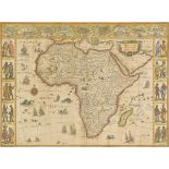

Africa. Blaeu (Willem), Africa nova descriptio, circa 1650, hand coloured engraved 'carte-a-figures'
Africa. Blaeu (Willem), Africa nova descriptio, circa 1650, hand coloured engraved 'carte-a-figures' map, central fold partially split, old folds,...
Algeria. Homann (Johann Baptist, heirs of), Topographica Repraesentatio Barbarici Portus et Urbis
Algeria. Homann (Johann Baptist, heirs of), Topographica Repraesentatio Barbarici Portus et Urbis Munitae Oran..., 1732, engraved map with contemp...
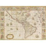
Americas. Blaeu (Willem), Americae nova Tubuala, circa 1650, hand coloured engraved 'carte-a-
Americas. Blaeu (Willem), Americae nova Tubuala, circa 1650, hand coloured engraved 'carte-a-figures' map, some dust soiling, slight staining, arc...
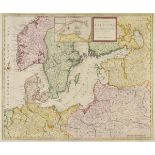
Baltic and Scandinavia. Moll (Herman), A New Map of the Baltic &c. Shewing all the Dominions about
Baltic and Scandinavia. Moll (Herman), A New Map of the Baltic &c. Shewing all the Dominions about it with ye Great or Post Roads and Principal Cr...
Battle of Waterloo. Eleven maps originally published in 'History of the War in France and Belgium in
Battle of Waterloo. Eleven maps originally published in 'History of the War in France and Belgium in 1815...,' by Captain W.Siborne, circa 1844, e...
Berkshire. Pride (Thomas), A Topographical Map of the Town of Reading and the Country adjacent to an
Berkshire. Pride (Thomas), A Topographical Map of the Town of Reading and the Country adjacent to an Extent of Ten Miles. Describing the Main and ...
British Isles. A collection of sixteen maps, mostly 17th & 18th century, including county maps by
British Isles. A collection of sixteen maps, mostly 17th & 18th century, including county maps by Speed, Bowen and Jansson, maps of the British Is...
British Isles. Allard (Carel), Accuratissima Angliae, Scotiae et Hiberniae..., published Amsterdam, circa 1690, uncoloured engraved map with two e...
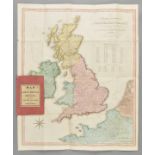
British Isles. The United Kingdom of Great Britain & Ireland, with the adjacent parts of the
British Isles. The United Kingdom of Great Britain & Ireland, with the adjacent parts of the Continent, from Amsterdam, to Paris and Brest, Compil...
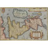
British Isles. Ortelius (Abraham), Angliae, Scotiae et Hiberniae sive Britannicar: Insularum
British Isles. Ortelius (Abraham), Angliae, Scotiae et Hiberniae sive Britannicar: Insularum Descriptio, [1570 or later], engraved map with contem...
British Isles. Merian (Matthaus), Magnae Britanniae et Hiberniae nova Descriptio, circa 1670, hand
British Isles. Merian (Matthaus), Magnae Britanniae et Hiberniae nova Descriptio, circa 1670, hand coloured engraved map, 310 x 380 mm, mounted, f...
Camden (William). Camden's Britannia 1695, a facsimile of the 1695 edition, 1971, numerous black
Camden (William). Camden's Britannia 1695, a facsimile of the 1695 edition, 1971, numerous black and white maps, publisher's original gilt decora...
Canals. Wells (Lionel B.), Map of the Canals and Navigable Rivers of England & Wales, published
Canals. Wells (Lionel B.), Map of the Canals and Navigable Rivers of England & Wales, published George Falkner & Sons, Manchester, circa 1900, lar...
Celestial Chart. Cellarius (Andreaus), Theoria Veneris et Mer Curii, published Amsterdam, circa
Celestial Chart. Cellarius (Andreaus), Theoria Veneris et Mer Curii, published Amsterdam, circa 1690, engraved celestial chart with contemporary h...
Celestial Charts. Dunn (Samuel), Cosmography Epitomised, in Six Copper Plate Delineations, published
Celestial Charts. Dunn (Samuel), Cosmography Epitomised, in Six Copper Plate Delineations, published Robert Sayer, 1786, six (complete) uncoloured...
Constantinople. Munster (Sebastian), L'effigie de la Ville de Constantinoble selon qu'elle est de
Constantinople. Munster (Sebastian), L'effigie de la Ville de Constantinoble selon qu'elle est de nostre temps soubz le Turc, published Basle, cir...
Cornwall. Speed (John), Cornwall, published Thomas Bassett & Richard Chiswell, circa 1676, engraved map with sparse early colouring, inset view of...
Devon. Saxton (Christopher & Kip William), Devoniae Comitatus Vulgo Denshyre olim Danmonii Populi
Devon. Saxton (Christopher & Kip William), Devoniae Comitatus Vulgo Denshyre olim Danmonii Populi Incoluerunt, circa 1610, hand coloured engraved ...
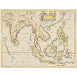
East Indies. Speed (John), A New Map of East India, published Thomas Bassett & Richard Chiswell,
East Indies. Speed (John), A New Map of East India, published Thomas Bassett & Richard Chiswell, circa 1676, hand coloured engraved map, slight ma...
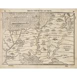
Egypt & Palestine. Bunting (Heinrich), Reissen der Kinder von Israel aus Egypten, circa 1585,
Egypt & Palestine. Bunting (Heinrich), Reissen der Kinder von Israel aus Egypten, circa 1585, uncoloured woodblock map, 280 x 365 mm, German text...
English Channel. Van Keulen (Johannes), Nieuwe Wassende Graade paskaart Van t' Canaal Tusschen
English Channel. Van Keulen (Johannes), Nieuwe Wassende Graade paskaart Van t' Canaal Tusschen Englalandt en Vrankr˜k..., published Amsterdam, cir...
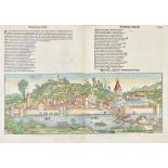
Germany. Schedel (Hartmann), Ulma, published Nuremberg, circa 1493, hand coloured woodcut double
Germany. Schedel (Hartmann), Ulma, published Nuremberg, circa 1493, hand coloured woodcut double page panorama of the city of Ulm, some restorati...
Greece. Langlois (Nicolas, publisher), Grece Moderne ou Partie Meridional de la Turquie en L'Europe,
Greece. Langlois (Nicolas, publisher), Grece Moderne ou Partie Meridional de la Turquie en L'Europe, published Paris, 1685, engraved map by Jan Sw...
Greenwood (C. & J., publishers). Map of the County of Wilts from an Actual Survey [and] Map of the
Greenwood (C. & J., publishers). Map of the County of Wilts from an Actual Survey [and] Map of the County of Berks from an Actual Survey, 1829, tw...
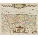
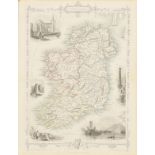
Ireland. Morden (Robert), The Kingdom of Ireland [1695 or later], hand coloured engraved map, 420
Ireland. Morden (Robert), The Kingdom of Ireland [1695 or later], hand coloured engraved map, 420 x 350 mm, mounted, framed and glazed, together w...
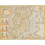
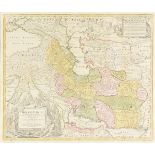
Ireland. Speed (John), The Kingdom of Ireland Devided into Severall Provinces and then againe
Ireland. Speed (John), The Kingdom of Ireland Devided into Severall Provinces and then againe devided into Counties Newly Described, published Joh...
Lancashire. Speed (John), The Countie Pallatine of Lancaster Described and Divided into Hundreds,
Lancashire. Speed (John), The Countie Pallatine of Lancaster Described and Divided into Hundreds, 1st edition, published G.Humble, circa 1611, han...
Lebanon. Fuller (Thomas), Libanus et ejuus Vicinia, circa 1650, hand coloured engraved map, vignettes of agriculture and battles, large compass ro...
London. Map of London, with the New Streets, Railways, Public Buildings, &c., and Several Hundred
London. Map of London, with the New Streets, Railways, Public Buildings, &c., and Several Hundred References to their situations forming a Complet...
Maps. A mixed collection of seven maps, 17th & 18th century, including regional maps of France,
Maps. A mixed collection of seven maps, 17th & 18th century, including regional maps of France, Spain & Portugal, Europe, The Netherlands, Moravia...
Maps. A mixed collection of nine maps of British counties, islands and regions, 17th - 19th century,
Maps. A mixed collection of nine maps of British counties, islands and regions, 17th - 19th century, engraved maps, with examples by Thomson, Jans...
Maps. A mixed collection of approximately fifty-five maps, mostly 17th & 18th century, engraved
Maps. A mixed collection of approximately fifty-five maps, mostly 17th & 18th century, engraved maps, many with contemporary hand colouring, inclu...
Maps. A mixed collection of approximately eighty maps and charts, mostly 19th century, British
Maps. A mixed collection of approximately eighty maps and charts, mostly 19th century, British county maps, sea charts and foreign maps, including...
Maps. A mixed collection of approximately eighty maps, mostly 18th & 19th century, engraved and
Maps. A mixed collection of approximately eighty maps, mostly 18th & 19th century, engraved and lithographic foreign maps, including examples by W...
Mexico. Coronelli (Vicenzo Maria), Parte della Nuova Spagna • del Mexico doue sono le Provincie di
Mexico. Coronelli (Vicenzo Maria), Parte della Nuova Spagna • del Mexico doue sono le Provincie di Guadalaira, Xalisco, Mecoacan, Mexico...., pub....
Moluccan Islands Blaeu (Willem Janszoon), Moluccae Insulae Celeberrimae, circa 1609, engraved map
Moluccan Islands Blaeu (Willem Janszoon), Moluccae Insulae Celeberrimae, circa 1609, engraved map with contemporary hand colouring, inset map of t...
Monmouthshire. A collection of twenty-one county maps, mostly 19th century, engraved maps, many with
Monmouthshire. A collection of twenty-one county maps, mostly 19th century, engraved maps, many with hand colouring, including examples by Smith, ...
North Africa. Blaeu (Willem Janszoon), Fezzae et Marocchi Regna Africae Celeberrima describebat
North Africa. Blaeu (Willem Janszoon), Fezzae et Marocchi Regna Africae Celeberrima describebat Abrah. Ortelius, published Amsterdam, circa 1640, ...
North America. Homann (Johann Baptist, heirs of), Dominia Anglorum in America Septentrionali...,
North America. Homann (Johann Baptist, heirs of), Dominia Anglorum in America Septentrionali..., circa 1740, four engraved maps on one sheet (Virg...
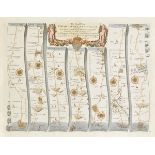
Ogilby (John). The Road from Oxford to Coventry Continued, The Continuation of the Road from
Ogilby (John). The Road from Oxford to Coventry Continued, The Continuation of the Road from London to the Lands-End, The Road from London to St N...
Ogilby (John). The Road from London to Montgomery North Wales, circa 1676, hand coloured engraved
Ogilby (John). The Road from London to Montgomery North Wales, circa 1676, hand coloured engraved map, 325 x 450 mm, mounted, framed and glazed, t...
Ogilby (John). The Road from Bristol co. Glouc. to Banbury com. Oxo., circa 1676, hand coloured
Ogilby (John). The Road from Bristol co. Glouc. to Banbury com. Oxo., circa 1676, hand coloured engraved strip road map, 340 x 450 mm, mounted, fr...
Ortelius (Abraham). Geographia (Sacra), c.1600, uncoloured engraved map, 365 x 485 mm Marcel van den
Ortelius (Abraham). Geographia (Sacra), c.1600, uncoloured engraved map, 365 x 485 mm Marcel van den Broecke, Ortelius Atlas Maps no.179. E.Laor. ...
Palestine. Visscher (Nicolas), Terra Sancta sive Promissionis olim Palestina recens delineata et
Palestine. Visscher (Nicolas), Terra Sancta sive Promissionis olim Palestina recens delineata et in Lucem edita, per Nicolaum Visscher, Anno. 1659...

Palestine. Sanson (Nicolas) Situs Terrae Canaan sive Terrae Promissionis Hodie Palestinae..., pub.
Palestine. Sanson (Nicolas) Situs Terrae Canaan sive Terrae Promissionis Hodie Palestinae..., pub. Amsterdam, J.Covens & C.Mortier, circa 1730, e...
Pembrokeshire. Blaeu (Johannes), Penbrochia Comitatus et Comitatus Caermaridunum, circa 1648, hand
Pembrokeshire. Blaeu (Johannes), Penbrochia Comitatus et Comitatus Caermaridunum, circa 1648, hand coloured engraved map, decorative cartouche, 41...
Persia. Homann (Johann Baptist), Imperii Persici in Omnes suas Provincias..., published Nuremberg,
Persia. Homann (Johann Baptist), Imperii Persici in Omnes suas Provincias..., published Nuremberg, circa 1730, engraved map with contemporary hand...
Shropshire. Speed (John), Shropshyre Described, The Situation of Shrowesbury Shewed with the Armes
Shropshire. Speed (John), Shropshyre Described, The Situation of Shrowesbury Shewed with the Armes of thos Earles and other Memorable things obser...
Speed (John). A collection of nineteen county maps, [1611 and later], engraved county maps, twelve
Speed (John). A collection of nineteen county maps, [1611 and later], engraved county maps, twelve with hand colouring, all with defects, tears an...
Suffolk. Valk (Gerard & Schenk Pieter), Suffolcia vernacula Suffolke, circa 1700, hand coloured
Suffolk. Valk (Gerard & Schenk Pieter), Suffolcia vernacula Suffolke, circa 1700, hand coloured engraved map, large decorative cartouche and milea...
Tallis (J. & F., publishers). A collection of thirty-five engraved maps, circa 1860, decorative
Tallis (J. & F., publishers). A collection of thirty-five engraved maps, circa 1860, decorative engraved maps by J.Rapkin, contemporary outline co...
Warwickshire. Speed (John), The Counti of Warwick, The Shire Towne and Citie of Coventre Described, published Thomas Bassett & Richard Chiswell, c...
Warwickshire. Speed (John), The Counti of Warwick The Shire Towne and the Citie of Coventre Described, published John Sudbury and George Humble, c...
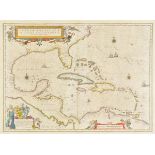
West Indies. Blaeu (Willem Janszoon), Insulae Americanae in Oceano Septentrionali cum Terris
West Indies. Blaeu (Willem Janszoon), Insulae Americanae in Oceano Septentrionali cum Terris Adjacentibus, [1642], hand coloured engraved map stre...
West Indies. Homann (Johann Baptist, heirs of), Dominia Anglorum in Praecipuis Insulis Americae..., circa 1740, five engraved maps on one sheet (S...
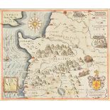
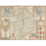
![Wiltshire. Speed (John), Wilshire, published John Sudbury & G.Humble, [1616], hand coloured engraved](https://portal-images.azureedge.net/auctions-2015/srdom10048/images/48206426-2068-4ec9-b88e-f58b4d10ff07.jpg?w=155&h=155)
Wiltshire. Speed (John), Wilshire, published John Sudbury & G.Humble, [1616], hand coloured engraved
Wiltshire. Speed (John), Wilshire, published John Sudbury & G.Humble, [1616], hand coloured engraved map, inset map of Salisbury, with a vignette ...
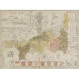
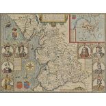
Wiltshire. Saxton (Christopher & Kip William), Wiltoniae Comitatus herbida Planicie nobilis vulgo
Wiltshire. Saxton (Christopher & Kip William), Wiltoniae Comitatus herbida Planicie nobilis vulgo Willshire pars olim Belgarum, [1637], hand colou...
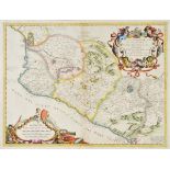
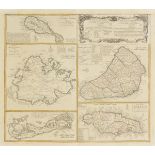
![Wiltshire Speed (John), Wilshire, [1616], engraved map with contemporary hand colouring, inset](https://portal-images.azureedge.net/auctions-2015/srdom10048/images/6bbce87f-d43d-420a-a06b-4168bf0882ee.jpg?w=155&h=155)
Wiltshire Speed (John), Wilshire, [1616], engraved map with contemporary hand colouring, inset
Wiltshire Speed (John), Wilshire, [1616], engraved map with contemporary hand colouring, inset town plan of Salisbury, inset engraved vignette of ...