Filtered by:
- Category,
- Item Type
- List
- Grid
This auctioneer has chosen to not publish their results. Please contact them directly for any enquiries.
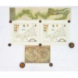

Maps: Four assorted maps comprising a colour map titled Orbis Terrae Compendiosa Descriptio, a
Maps: Four assorted maps comprising a colour map titled Orbis Terrae Compendiosa Descriptio, a double hemisphere map of the World after Johannes B...
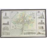
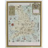
Map: A late 20thC plan of the town of Northampton after Thomas Jefferys (c. 1719-1771), with a map
Map: A late 20thC plan of the town of Northampton after Thomas Jefferys (c. 1719-1771), with a map of the town, and views of the Church of All Sai...
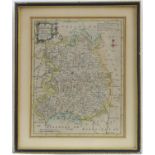
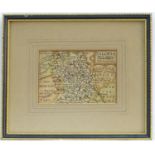
Map: A 19thC hand coloured engraved map of Shropshire after Thomas Moule (1784-1851), decorated with
Map: A 19thC hand coloured engraved map of Shropshire after Thomas Moule (1784-1851), decorated with a border of coats of arms, views of Ludlow Ca...
Map: An 18thC hand coloured engraved map of Shropshire, after John Cary (1755-1835). Approx. 10 1/2"
Map: An 18thC hand coloured engraved map of Shropshire, after John Cary (1755-1835). Approx. 10 1/2" x 8 1/2"Please Note - we do not make referen...
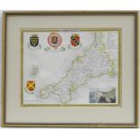
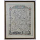
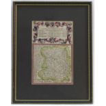
Map: A 19thC hand coloured engraved map of Cornwall after Thomas Moule (1784-1851) with coats of
Map: A 19thC hand coloured engraved map of Cornwallafter Thomas Moule (1784-1851) with coats of arms and a view of Lands End. Approx. 8" x 10 1/4"...
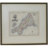
Map: A 19thC hand coloured engraved map of Cornwall including the Scilly Isles, after Benjamin
Map: A 19thC hand coloured engraved map of Cornwall including the Scilly Isles, after Benjamin Rees Davies (1789-1872), with a view of the Cheese ...
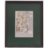
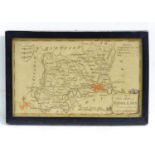
Map: A John Speed coloured map of Rutlandshire with inset plans of Oukham and Stanford. Approx. 14
Map: A John Speed coloured map of Rutlandshire with inset plans of Oukham and Stanford. Approx. 14 1/2" x 19 1/2"Please Note - we do not make ref...
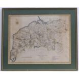
Map: A 19thC hand coloured engraved map of Cumberland, after John Cary (1755-1835). Approx. 16" x
Map: A 19thC hand coloured engraved map of Cumberland, after John Cary (1755-1835). Approx. 16" x 20"Please Note - we do not make reference to th...
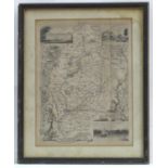
After James Joseph Lloyd Carr (1912-1994), A literary and historical map of England and Wales, drawn
After James Joseph Lloyd Carr (1912-1994), A literary and historical map of England and Wales, drawn in 1943 by Carr. Approx. 24? x 17 ½?Please No...
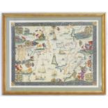
After Gerardus Mercator (1512-1594), A 20thC decorative map depicting part of the Mediterranean,
After Gerardus Mercator (1512-1594), A 20thC decorative map depicting part of the Mediterranean,circa 1600. To include Africa Barbaria, the Africa...
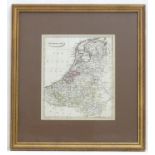
A 19thC hand coloured map of the Netherlands, by J. C. Russell Jnr. Approx. 9" x 7 1/2" Please
A 19thC hand coloured map of the Netherlands, by J. C. Russell Jnr. Approx. 9" x 7 1/2"Please Note - we do not make reference to the condition o...
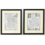
Maps: Two monochrome engraved and hand coloured county maps, one depicting Momouthshire with a
Maps: Two monochrome engraved and hand coloured county maps, one depicting Momouthshire with a view of Chepstow Castle and Tintern Abbey; the othe...
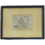
Map: An 18thC hand coloured engraved road strip map of Cornwall, showing the route from Tregony to
Map: An 18thC hand coloured engraved road strip map of Cornwall, showing the route from Tregony to Penzance, after John Owen and Emanuel Bowen, wi...
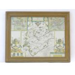
Map: A 19thC engraved map of Nottinghamshire after Thomas Moule (1784-1851), with coats of arms,
Map: A 19thC engraved map of Nottinghamshire after Thomas Moule (1784-1851), with coats of arms, views of Worksop Manor, Nottingham Castle and New...
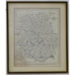
Map: An 18thC hand coloured engraved map of Shropshire after Thomas Kitchin (1718?1784). Approx. 9
Map: An 18thC hand coloured engraved map of Shropshire after Thomas Kitchin (1718?1784). Approx. 9 3/4" x 7 3/4"Please Note - we do not make refe...
Map: A 19thC double sided road map from London to Shewsbury, the reverse with a road strip map of
Map: A 19thC double sided road map from London to Shewsbury, the reverse with a road strip map of Shropshire, showing the route from Warwick to Sh...
Map: An 18thC engraved map of Buckinghamshire after Pieter Van den Keere (1571-c. 1646). Approx. 3
Map: An 18thC engraved map of Buckinghamshire after Pieter Van den Keere (1571-c. 1646). Approx. 3 1/2" x 4 3/4"Please Note - we do not make refe...
Map: An 18thC hand coloured engraved map of Shrewsbury, titled Salopia after Pieter van den Keere (
Map: An 18thC hand coloured engraved map of Shrewsbury, titled Salopia after Pieter van den Keere (1571-c. 1646). Approx. 3 1/4" x 4 3/4"Please No...
Map: An 18thC map of Middlesex after Thomas Conder (1784-1812). Approx. 4" x 6 3/4" Please Note - we
Map: An 18thC map of Middlesex after Thomas Conder (1784-1812). Approx. 4" x 6 3/4"Please Note - we do not make reference to the condition of lot...
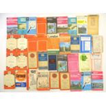
A quantity of assorted 20thC Ordnance Survey maps. Please Note - we do not make reference to the
A quantity of assorted 20thC Ordnance Survey maps.Please Note - we do not make reference to the condition of lots within descriptions. We are how...