Filtered by:
- Category,
- Creator / Brand
- List
- Grid
This auctioneer has chosen to not publish their results. Please contact them directly for any enquiries.
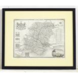

A 19thC monochrome engraved county map after Thomas Moule depicting Hampshire with a vignette view
A 19thC monochrome engraved county map after Thomas Moule depicting Hampshire with a vignette view of Southampton. Approx. 8" x 10 1/4"Please Note...
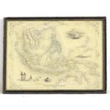
Map: A 19thC engraved and hand coloured map after J. Rapkin depicting Malay Archipelago or East
Map: A 19thC engraved and hand coloured map after J. Rapkin depicting Malay Archipelago or East India Islands, with illustrations of Victoria Moun...
Maps: Two 18thC maps of Bedfordshire, comprising a hand coloured road strip map, published in John
Maps: Two 18thC maps of Bedfordshire, comprising a hand coloured road strip map, published in John Owen & Emanuel Bowen's Britannia Depicta or Ogi...
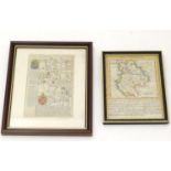
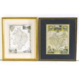
Maps: Two monochrome engraved and hand coloured county maps, one depicting Momouthshire with a
Maps: Two monochrome engraved and hand coloured county maps, one depicting Momouthshire with a view of Chepstow Castle and Tintern Abbey; the othe...
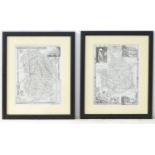
Maps: Two engraved and hand coloured county maps after Thomas Moule, one depicting Warwickshire with
Maps: Two engraved and hand coloured county maps after Thomas Moule, one depicting Warwickshire with a view of Kenilworth Castle and Warwick Castl...
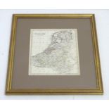
A 19thC hand coloured map of the Netherlands, by J. C. Russell Jnr. Approx. 9" x 7 1/2" Please
A 19thC hand coloured map of the Netherlands, by J. C. Russell Jnr. Approx. 9" x 7 1/2"Please Note - we do not make reference to the condition o...