Filtered by:
- Category,
- Item Type
- List
- Grid
This auctioneer has chosen to not publish their results. Please contact them directly for any enquiries.
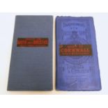

Two early 20thC Bartholomew?s maps, New Reduced Survey for Tourists and Cyclists, mounted on
Two early 20thC Bartholomew?s maps, New Reduced Survey for Tourists and Cyclists, mounted on cloth, 2" to 1 mile. To include Sheet 28 Bath, and Sh...
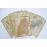
A collection of fourteen 19thC coloured maps depicting regions of Germany after Louis Gerstner, (
A collection of fourteen 19thC coloured maps depicting regions of Germany after Louis Gerstner, (XIX), Leipzig. Each approx. 14? x 10? (14)Please ...
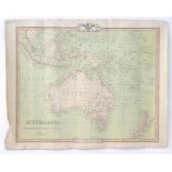
Map: A 19thC engraved map of Australia, New Zealand and East India Islands, engraved and published
Map: A 19thC engraved map of Australia, New Zealand and East India Islands, engraved and published by G. F. Crutchley. Approx. 15 1/2" x 18 1/2"Pl...
Map: An engraved and hand coloured map of The Province of Leinster, Ireland. Showing the borders
Map: An engraved and hand coloured map of The Province of Leinster, Ireland. Showing the borders of Ulster, Connough, Mounster etc. Approx. 19 1/2...
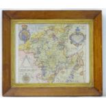
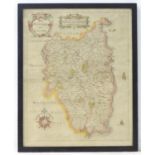
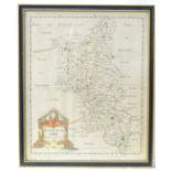
Map: An engraved and hand coloured map of Worcestershire after Christopher Saxton. Approx. 11" x 12"
Map: An engraved and hand coloured map of Worcestershire after Christopher Saxton. Approx. 11" x 12"Please Note - we do not make reference to the...
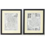
Maps: Two monochrome engraved and hand coloured county maps, one depicting Momouthshire with a
Maps: Two monochrome engraved and hand coloured county maps, one depicting Momouthshire with a view of Chepstow Castle and Tintern Abbey; the othe...
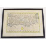
An 18thC hand coloured map of Sussex engraved by Thomas Kitchin (1718-1784) and published in Henry
An 18thC hand coloured map of Sussex engraved by Thomas Kitchin (1718-1784) and published in Henry Boswell's atlas Antiquities of England & Wales....
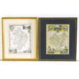
Maps: Two engraved and hand coloured county maps after Thomas Moule, one depicting Warwickshire with
Maps: Two engraved and hand coloured county maps after Thomas Moule, one depicting Warwickshire with a view of Kenilworth Castle and Warwick Castl...
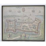
Map: a framed, hand coloured view of Calais (contemporarily produced after Braun and Hogenberg
Map: a framed, hand coloured view of Calais (contemporarily produced after Braun and Hogenberg 1597), 12 7/8" x 15 3/4"Please Note - we do not ma...
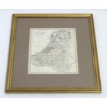
A 19thC hand coloured map of the Netherlands, by J. C. Russell Jnr. Approx. 9" x 7 1/2" Please
A 19thC hand coloured map of the Netherlands, by J. C. Russell Jnr. Approx. 9" x 7 1/2"Please Note - we do not make reference to the condition o...
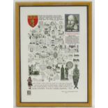
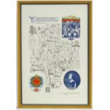
After James Joseph Lloyd Carr (1912-1994), A limited edition (no. 276/526) literary and historical
After James Joseph Lloyd Carr (1912-1994), A limited edition (no. 276/526) literary and historical map of Warwickshire, with a portrait of Willia...
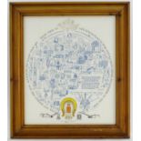
After James Joseph Lloyd Carr (1912-1994), A limited edition (no. 148/500) literary and historical
After James Joseph Lloyd Carr (1912-1994), A limited edition (no. 148/500) literary and historical map of the County of Rutland. Signed J L Carr l...
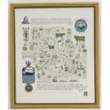
After James Joseph Lloyd Carr (1912-1994), A limited edition (no. 312/350) literary and historical
After James Joseph Lloyd Carr (1912-1994), A limited edition (no. 312/350) literary and historical map of Huntingdonshire, with a portrait of Oliv...
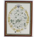
After James Joseph Lloyd Carr (1912-1994), Limited edition (no. 283/503) literary and historical map
After James Joseph Lloyd Carr (1912-1994), Limited edition (no. 283/503) literary and historical map of The County of Devon. Signed J L Carr lower...
After James Joseph Lloyd Carr (1912-1994), A limited edition (no. 155/172) literary and historical
After James Joseph Lloyd Carr (1912-1994), A limited edition (no. 155/172) literary and historical map of Worcestershire. Signed J L Carr lower mi...
Map: A map of Buckinghamshire by Sutton Nicholls after Robert Morden. Showing the borders Northamptonshire, Oxfordshire, Barkshire, Hertfordshire,...
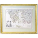
Map: An engraved and hand coloured map by W. Palmer after Louis Stanislas d'Arcy Delarochette
Map: An engraved and hand coloured map by W. Palmer after Louis Stanislas d'Arcy Delarochette depicting Greece, Archipelago and Anadoli. Approx. 2...