Filtered by:
- Category,
- Creator / Brand
- List
- Grid
A subscription to the Price Guide is required to view results for auctions ten days or older. Click here for more information

Janet SWANBOROUGH View to Round Island, St Helens and Tresco, Isles of Scilly GouacheSigned and
Janet SWANBOROUGH View to Round Island, St Helens and Tresco, Isles of Scilly GouacheSigned and dated '8024 x 37cm ...[more]
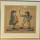
George I CRUIKSHANK (1792-1878) William Holland 1798 publisher What do you want, Paddy?? Coloured
George I CRUIKSHANK (1792-1878)William Holland 1798 publisherWhat do you want, Paddy??Coloured etching33 x 37.5cm
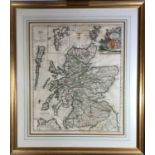
Map, hand colouredJohn SENEX (1678-1740)A New Map of Scotland 172157x48cm ...[more]
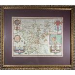
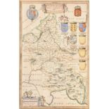
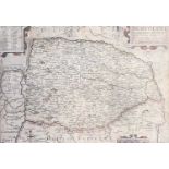
Map, brightly hand colouredJohn SPEEDEMerionethshire described 1610Inset town plan of HarlechSold by
Map, brightly hand colouredJohn SPEEDEMerionethshire described 1610Inset town plan of HarlechSold by Thomas Bassett & Richard Chiswell51 x 39cm ....
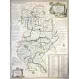
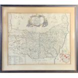
Map, handcolouredEmanuel BOWEN (1694-1767)An Accurate Map of Bedford divided into its Hundreds c.
Map, handcolouredEmanuel BOWEN (1694-1767)An Accurate Map of Bedford divided into its Hundreds c.1749 70 x 52.3cm ...[more]
Map, handcolouredEman. BOWEN (1694-1767)Shrop Shire 51.5 x 70.8cm
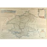
Map, handcoloured T. KITCHINPembrokeshire57 x 35.5cm ...[more]
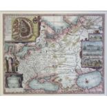
Map, handcoloured Johannes BLAEU (1596-1673) Bvuckingham Shire27.6 x 42.4cm
Map, handcoloured Richard BlomeA Map of the County of Suffolk with its HundredsBritannia 1673Dedicated to Thomas Timperley26.5 x 32.1cm ...[more]
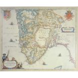
Map, hand coloured.William Kipp (c.1588-1635) after Christophore SAXTON (c.1540-c.1610)Norfolcae
Map, hand coloured.William Kipp (c.1588-1635) after Christophore SAXTON (c.1540-c.1610)Norfolcae comitatus.quem oliDCXXV38.7 x 28.9cm ...[more]
Map, handcolouredDresdenReproduction after the antique35.5x89cmTogether with other maps, The
Map, handcolouredDresdenReproduction after the antique35.5x89cmTogether with other maps, The World, Essex & Shropshire ...[more]
Map, reproduction after the antiqueDioesis Stavangriensis by L. Scavenii.Together with two other
Map, reproduction after the antiqueDioesis Stavangriensis by L. Scavenii.Together with two other framed reproduction maps41 x 34cm ...[more]
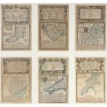
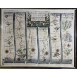
Maps, handscolouredOWEN & BOWENSix 18th century road maps in one frame. London to Aberistwith;
Maps, handscolouredOWEN & BOWENSix 18th century road maps in one frame. London to Aberistwith; London to Holy-Head; Dartmouth; Monmouth to Lanbede...
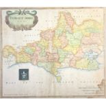
Map, handcolouredRob MORDEN (1650-1703)Dorset Shire sold by Abel Swale Awnsham and John Churchill.
Map, handcolouredRob MORDEN (1650-1703)Dorset Shire sold by Abel Swale Awnsham and John Churchill.From Camden's Britannia 169542.2 x 37cm ...[mor...
Map, handcolouredAfter Abrahami ORTELY (1527-1598)Agyptvs Antiqva 159549.1 x 39.2cm ...[more]
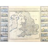
Map, handcolouredSutton NICHOLLS Sculp (1668-1729)A new map of England and Wales. Printed for and
Map, handcolouredSutton NICHOLLS Sculp (1668-1729)A new map of England and Wales. Printed for and sold by Io Smith in Exeter Change in the Strand ...
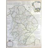
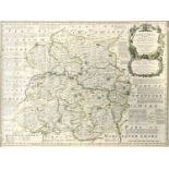
Map, handcolouredEmanuel BOWEN (1694-1767) An accurate map of Lincolnshire. Divided into its
Map, handcolouredEmanuel BOWEN (1694-1767) An accurate map of Lincolnshire. Divided into its Wapontakes51.8 x 70.6cm
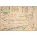
Map, handcolouredJohn SPEED (1552-1629)A Map of Russia engraved by Francis LambSold by Thos
Map, handcolouredJohn SPEED (1552-1629)A Map of Russia engraved by Francis LambSold by Thos Basset & Richard ChiswellInset town plan of Moscow and...
18th century road maps, hand colouredMonmouth to Llanbeder by John Ogilby35.5x45.5cmTogether with
18th century road maps, hand colouredMonmouth to Llanbeder by John Ogilby35.5x45.5cmTogether with four other smaller framed road maps (two maps do...