Filtered by:
- Category,
- Item Type
3 items
- List
- Grid
A subscription to the Price Guide is required to view results for auctions ten days or older. Click here for more information
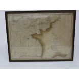

A chart of the British Channel and the Bay of Biscay, circa 1780, 54cm X 74cm.

Lot 337
A Reynold's cyclists' road map of London, late 19th century, and an assortment of other maps,
A Reynold's cyclists' road map of London, late 19th century, and an assortment of other maps, prints, postcards etc.
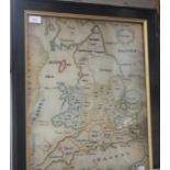
A silkwork map of England and Wales, early 19th century, by Cecilia Basset, the counties bordered in colours, also with the Channel Islands, 52 x ...