Refine your search
Filtered by:
- Category
- List
- Grid
A subscription to the Price Guide is required to view results for auctions ten days or older. Click here for more information

GARRAN (ANDREW). "Picturesque Atlas of Australia." Vol 1 only, 12 maps (of 16) plts etc, cont 1/2 mor, lg fl, 1886
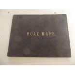
ROAD MAPS IN STRIP FORM. Vol titled "Road Maps." incomplete but with 50 engr strip maps on 25 leaves, similar to Ogilby's Britannia of 1675. 19c c...

ARABIA. "Phillips Map of Egypt, The Soudan, The Valley of the Nile ... Arabia." col folding linen-backed map, approximately 24x25 inches, orig cl ...

ETON COLLEGE. Children's Book being "Geographical Questions and Answers ... Instruction of Young Minds." (no map) 56 pp comp, cont sheep, 16 mo, E...
BORLASE (WILLIAM). "Antiquities, Historical & Monumental of the County of Cornwall ..." 2nd revised edn, 37 engr plts comp incl 2 maps, later 1/4 ...

VAN KEULAN "De River van Falmouth en Helfort Found..." engraved map, 13x19 inches, c1740s, vg.
VAN KEULAN "De River van Falmouth en Helfort Found..." engraved map, 13x19 inches, c1740s, vg. Condition report: Very good condition

WALPOOLE (G.A.).
WALPOOLE (G.A.). "The New British Traveller, or, A Complet Modern Universal Display of Great-Britain & Ireland..." folding & other maps, comp, vie...

WRIGHT (THOMAS). "The History & Topography of the County of Essex." Vol only, hand col folidng map, & engr plts comp therein, cont cf, taped 4to, ...

BRITTON (J.) & BRAYLEY (E.W.). "Devonshire & Cornwall Illustrated." 2 maps vignettes & engr views comp, cont cf rebacked, 4to 1829-31 good.

STOCKDALE (F.W.L.) "Excursions in the County of Cornwall..." folding engr map & views comp, cf det, 8vo 1833; GILBERT (C.S.) "An Historical Survey...
S.W. FORES.
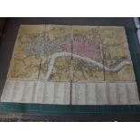
S.W. FORES. "Fores's New Large Plan of London with the Names of the Streets Alphabetically Arranged & directions to find them in the MAP." hand co...
IPSWICH. "Borough of Ipswich.
IPSWICH. "Borough of Ipswich."manu map, 40 x 26 inches, Oct 1928; plus town maps of Southend, Chelmsford, Hendon; plus rolled Ordnance Survey maps...
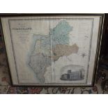
ENGRAVED MAP. "Map of the County of Cumberland ... " by C. & J. Greenwood hand col with vign, 26 x 30 inches, 1830 g.