Refine your search
Filtered by:
- Item Type
- List
- Grid
A subscription to the Price Guide is required to view results for auctions ten days or older. Click here for more information

Johannes (Joan) Blaeu (Dutch 1596-1673): 'Ducatus Eboracensis Anglice Yorkshire', 17th century engra
Johannes (Joan) Blaeu (Dutch 1596-1673): 'Ducatus Eboracensis Anglice Yorkshire', 17th century engraved map; Robert Morden (British c.1650-1703): ...
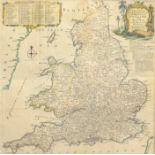
Thomas Kitchin (British 1719-1784): 'Most Accurate Map of the Roads of England and Wales with the Di
Thomas Kitchin (British 1719-1784): 'Most Accurate Map of the Roads of England and Wales with the Distances by the Mile Stones and other most exac...
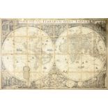
After Frederik de Wit (Dutch c.1629-1706): 'Nova Totius Terrarum Orbis Tabula', very large 20th cent
After Frederik de Wit (Dutch c.1629-1706): 'Nova Totius Terrarum Orbis Tabula', very large 20th century world map formed as 32 paper panels mounte...
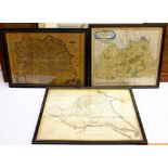
Richard Blome (British 1635-1705): 'A Mapp of Richmondshire', engraved map with later hand-colouring
Richard Blome (British 1635-1705): 'A Mapp of Richmondshire', engraved map with later hand-colouring pub. 1673; John Cary (British c.1754-1835): '...
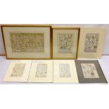
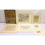
Owen & Bowen: 'Oxford', 'Preston' and 'New Radnor', three 18th century engraved strip maps with late
Owen & Bowen: 'Oxford', 'Preston' and 'New Radnor', three 18th century engraved strip maps with later hand-colouring; Thomas Bowen: 'A Map of the ...