Filtered by:
- Category,
- Item Type
- List
- Grid
A subscription to the Price Guide is required to view results for auctions ten days or older. Click here for more information
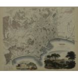

A 19th century framed and glazed hand colured town map of Naples published by Baldwin & Cradock.
A 19th century framed and glazed hand colured town map of Naples published by Baldwin & Cradock. Cartography by WB Clarke; engraved by T Bradley. ...
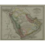
A framed and glazed antique map of Arabia by Geografia Commericale, showing the Persian Gulf. H.49
A framed and glazed antique map of Arabia by Geografia Commericale, showing the Persian Gulf. H.49 W.58cm
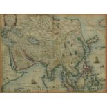
A framed and glazed 17th century hand coloured map of Asiae, Descriptio Nova Impensis Henrici
A framed and glazed 17th century hand coloured map of Asiae, Descriptio Nova Impensis Henrici Seile sculpted by Johan Goddard. H.50 W.60cm
A framed and glazed 19th century engraved map, titled 'Care du Government de l'Isle de France. H.
A framed and glazed 19th century engraved map, titled 'Care du Government de l'Isle de France. H.45 W.53cm
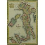
A framed and glazed hand coloured map of Johnson's Italy, by A.J. Johnson, New York. H.70 W.48cm
A framed and glazed hand coloured map of Johnson's Italy, by A.J. Johnson, New York. H.70 W.48cm
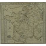
A framed and glazed antique map of 'Les Routes des postes du royaume de France' by Nicolas de Fer.
A framed and glazed antique map of 'Les Routes des postes du royaume de France' by Nicolas de Fer. H.63 W.70cm
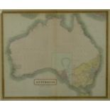
A framed and glazed 19th century hand coloured map of Australia by W & A.K. Johnston. H.62 W.71cm
A framed and glazed 19th century hand coloured map of Australia by W & A.K. Johnston. H.62 W.71cm ...[more]
A framed and glazed 18th century hand coloured map titled 'Gallia Antiqua ex aevi romani monumentis eruta' by Antonio Zatta. H.59 W.69cm
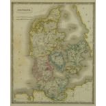
A framed and glazed 19th century hand coloured map of Denmark by Sidney Hall. Published by Longman, Rees, Browne & Green, 1828. H.76 W.65cm ......
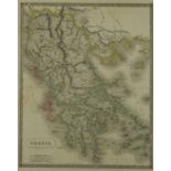
A framed and glazed 19th century hand coloured map of Greece by Sidney Hall. Published by Longman,
A framed and glazed 19th century hand coloured map of Greece by Sidney Hall. Published by Longman, Rees, Browne & Green, 1828. H.74 W.62cm ...[...
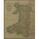
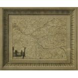
A framed and glazed 19th century hand coloured engraved Pigot & Sons' New Map of Wales from the
A framed and glazed 19th century hand coloured engraved Pigot & Sons' New Map of Wales from the new Survey. H.72 W.59cm ...[more]
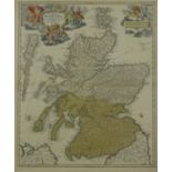
A framed and glazed 19th century hand coloured engraved map titled 'Magnae Birtanniae pars septentrionalisqua Regnum Scotiae by Iohan Bapt. Homann...
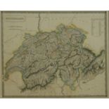
A framed and glazed 19th century map of Switzerland by Sidney Hall. Published by Longman, Rees,
A framed and glazed 19th century map of Switzerland by Sidney Hall. Published by Longman, Rees, Browne & Green. H.55 W.60cm ...[more]
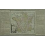
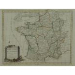
A framed and glazed 19th century hand coloured map of France, titled 'La France divide en fes
A framed and glazed 19th century hand coloured map of France, titled 'La France divide en fes quarante gouvernements generaux et militaires. H.46 ...
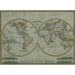
A framed and glazed hand coloured 18th century double hemisphere map of the world, titled Mappamonodo, Milano by Antonio Vallardi. Inscriptions in...
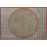
A framed and glazed 19th century hand coloured map, 'Selenographic map of the whole visible hemisphere of the Moon by I. Dower. H.35 W.28cm
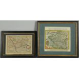
Two framed and glazed antique hand coloured maps. One of Westphaliae, Tabula Tertia. Along with
Two framed and glazed antique hand coloured maps. One of Westphaliae, Tabula Tertia. Along with Hondiv's map of France. H.34 W.30cm

Two framed and glazed antique maps. One titled Das Ander Buch, by Münster (1489-1552). The other a
Two framed and glazed antique maps. One titled Das Ander Buch, by Münster (1489-1552). The other a map of Guildford and Portsmouth. H.32 W.25cm
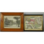
A framed and glazed 19th century engraving of 'A view from Eldfield near Oxford' by I Green and a
A framed and glazed 19th century engraving of 'A view from Eldfield near Oxford' by I Green and a framed and glazed 19th century map 'Magni Turcar...
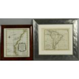
Two framed and glazed 18th century maps. One titled 'Coste Occidentale d'Afrique, depuit le Detroit de Gibraltar, by Bellin, 1738 and the other 'S...

Hans Jacob Hansen (1853-1947), figures on a North African street, signed. H.33.5 W.28.5cm