Filtered by:
- Sale Section,
- Category
5 items
- List
- Grid
A subscription to the Price Guide is required to view results for auctions ten days or older. Click here for more information
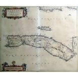

MapTimoth. Pont. Cantyra Cherfonefus a D Emie-Yland, cartouche lower left, 40cm x 50cm
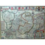
Map "Kent with her Cities and Earles described and observed", small vignette of Canterbury lower left and Rochester lower right, 40cm x 52cm with ...
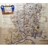
After Robert MordenMap "Hampshire", hand-coloured, 37cm x 43cm with the margin
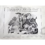
Facsimile "A Topographical Map of the County of Berkshire by John Rocque ...", published by Harry Margary in 1973, large folio with loose plates

Various framed prints, framed photograph, and a framed map of the Stroud valley area. ...[more]