
Filtered by:
- Category,
- Item Type
- List
- Grid
A subscription to the Price Guide is required to view results for auctions ten days or older. Click here for more information
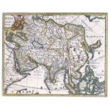

Map, Asia Antiqua et Nova
Philip Cluver (German, 1580-1623), "Asia Antiqua et Nova (1650)," hand-colored engraving, later edition circa 1690, image (sight): "8.25h x 10.25"...
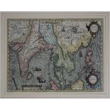
Map, Henricus Hondius the Younger
Henricus Hondius the Younger (Dutch, 1597-1651), "India Orientalis," 1609, hand-colored engraving, image (sight): 14"h x 19"w, overall (with frame...
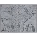
Map, Willem Janszoon Blaeu
Willem Janszoon Blaeu (Dutch, 1571-1638), "Aethiopia Superior vel Interior vulgo Abissinorum sive Presbiteri Ioannis Imperium (Map of Ethiopia)," ...
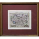
Map, Jan Jansson
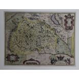
Johannes (Janssonius) Jansson (German, 1596-1666), "Tartaria," circa 1651, hand-colored engraving, image (sight): 5.63"h x 7.25"w, overall (with f...
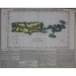
Map, H.C. Carey and I. Lea
Henry Charles Carey (American, 1793-1879) and Isaac Lea (American, 1792-1886), "Geographical, Statistical and Historical Map of Port Rico and the ...
Map, Willem Janszoon Blaeu
Willem Janszoon Blaeu (Dutch, 1571?1638), "Nova Virginiae Tabula," circa 1640, hand-colored copper engraving, image (sight): 14.75"h x 19"w, overa...
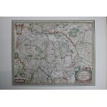
Map, Jan Jansson
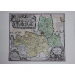
Johannes (Janssonius) Jansson (German, 1596?1666), "Nova Descripto Palatinatus Rheni," circa 1630, hand-colored engraving, image (sight): 15"h x 1...
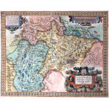
Map, Abraham Ortelius
Abraham Ortelius (Belgian, 1527?1598), "SALISBVRGENSIS IVRISDICTIONIS (Salisburgensis)," hand-colored engraving, printed circa 1603, image (sight)...
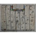
Map, John Ogilby
John Ogilby (British, 1600-1676), "The Road from York to Lancaster," 1657-1698, hand-colored engraving, image (sight): 13.5"h x 17.5"w, overall (w...
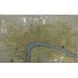
Map, John Noorthouck
John Noorthouck (British, 1732-1816), "A New and Accurate Plan of the Cities of London and Westminster, Including the New Roads & New Buildings," ...
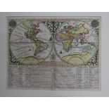
Map, Henri Abraham Chatelain
Henri Abraham Chatelain (French, 1684?1743), "Mappemonde ou Description Generale du Globe Terrestre," circa 1720, hand-colored engraving, image (s...
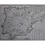
Map, Henri Abraham Chatelain
Henri Abraham Chatelain (French, 1684-1743), "Carte Historique et Geographique des Royaumes d'Espagne et de Portugal, 1719, hand-colored engraving...
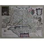
Map, Abraham Ortelius
Abraham Ortelius (Belgian, 1527-1598), "Burgundiae Comitatus," 1585, hand-colored engraving, image (sight): 14.25"h x 19.25"w, overall (with mat/u...
Map, Homann Heirs
Homann Heirs (German, 1664-1724), "Ingermanlandiae seu Ingriae Novissima Tabula Luci Tradita," 1740, hand-colored engraving, image (sight): 19.25"...
Map, Abraham Ortelius
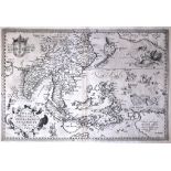
Abraham Ortelius (Belgian, 1527-1598), "Indiae Orientalis, Insularumque Adiacientium Typus," 1601, engraving, image (sight): 13.5"h x 19.5"w, over...
Map, Gilles Robert de Vaugondy
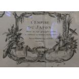
Gilles Robert de Vaugondy (French, 1688-1766), "L'Empire du Japon, Divise en Sept Principales Parties," 1750, hand-colored engraving, image (sight...
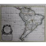
Map, Guillaume (de L'Isle) Delisle
Guillaume (de L'Isle) Delisle (French, 1675-1726), "L'Amerique Meridionale," 1720, hand-colored engraving, image (sight): 19"h x 23"w, overall (wi...
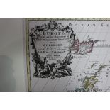
Map, Guillaume (de L'Isle) Delisle
Guillaume (de L'Isle) Delisle (French, 1675-1726), "L'Europe," circa 1740, hand-colored engraving, image (sight): 19.75"h x 23"w, overall (with fr...
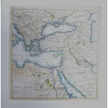
Map, Thomas Salmon
Thomas Salmon (British, 1679-1767), "The Whole Turkish Empire with the Countries and Territories Bordering Upon It...," circa 1745, hand-colored e...

Map, Herman Moll
Herman Moll (British, c. 1654-1732), "To the Right Honorable William Lord Cowper... This Map of Asia," circa 1720, hand-colored engraving, image (...