Refine your search
Filtered by:
- Category,
- Item Type
- List
- Grid
A subscription to the Price Guide is required to view results for auctions ten days or older. Click here for more information
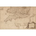

Jacques Nicolas Bellin (1703-1772)/Carte Reduite des Isles Britanniques en Cinq Feuilles ...
Jacques Nicolas Bellin (1703-1772)/Carte Reduite des Isles Britanniques en Cinq Feuilles ... Premiere Feuille Partie Meridionale de l'Angleterre, ...
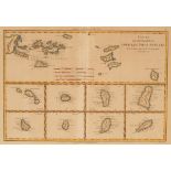
Rigobert Bonne/Cartes de Supplement hors des Isles Antilles/engraved map, 26cm x 37.5cm, framed and glazed CONDITION REPORT: Condition information...
John Ogilby/The Road from Dartmouth Com Devon to Minehead in the Com Somerset/hand coloured engraved map dated 1698, 36cm x 47cm CONDITION REPORT:...

John Speed, 1610/The Kingdome of Great Britaine and Ireland/hand coloured engraved map, 40.5cm x 53cm/with text on reverse/see illustration CONDIT...
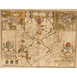
John Speed/Rutlandshire with Oukham and Stanford/hand coloured engraved map, 42cm x 53cm/with text on reverse CONDITION REPORT: Paper slightly dis...
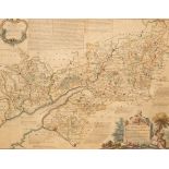
A map of the Counties of Gloucestershire and Monmouth, 1760, dedicated to the Hon. John Thynne, 52cm x 68cm, another of the same and three other m...
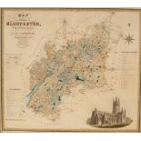
C and J Greenwood/Map of the County of Gloucester/published by Greenwood and Co., January 26th 1831, engraved map, 62cm x 70cm CONDITION REPORT: C...