Filtered by:
- Sale Section
- List
- Grid
This auctioneer has chosen to not publish their results. Please contact them directly for any enquiries.
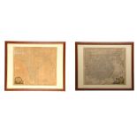

EAST ASIA. KITCHIN, Thomas (ca. 1710 – 1779). New Map of Indostan or East Indies agreeable to the
EAST ASIA. KITCHIN, Thomas (ca. 1710 – 1779). New Map of Indostan or East Indies agreeable to the latest Authorities. London [ca. 1782]. Hand-colo...
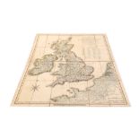
ENOUY, Joseph, George. The United Kingdom of Great Britain & Ireland, with the adjacent parts of the
ENOUY, Joseph, George. The United Kingdom of Great Britain & Ireland, with the adjacent parts of the Continent, from Amsterdam to Paris and Brest....
ENGLIGH TOPOGRAPHY. SAYER, Robert (1725–1794). England and Wales Drawn from the most accurate
ENGLIGH TOPOGRAPHY. SAYER, Robert (1725–1794). England and Wales Drawn from the most accurate Surveys… By John Rocque. London: 1780. ca. 1190 x 9...
![TALLIS, John (1815-1876) & John RAPKIN (1845/2851). Eastern Hemisphere. London, [ca. 1851]. Steel](https://portal-images.azureedge.net/auctions-2017/srchis10427/images/58751362-b0e0-4338-e8f9-e4f58da48860.jpg?w=155&h=155)
TALLIS, John (1815-1876) & John RAPKIN (1845/2851). Eastern Hemisphere. London, [ca. 1851]. Steel
TALLIS, John (1815-1876) & John RAPKIN (1845/2851). Eastern Hemisphere. London, [ca. 1851]. Steel hand coloured engravings. 265 x 335 mm (area vis...
![ESCAPE MAPS – [c. 1940’s-50’s]. A collection of maps on silk, covering areas such as French Indo](https://portal-images.azureedge.net/auctions-2017/srchis10427/images/fad32eaa-bb76-4af5-a6e3-1fa0c1a36241.jpg?w=155&h=155)
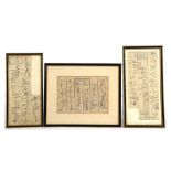
ESCAPE MAPS – [c. 1940’s-50’s]. A collection of maps on silk, covering areas such as French Indo
ESCAPE MAPS – [c. 1940’s-50’s]. A collection of maps on silk, covering areas such as French Indo China, Japan and South China Seas, Kenya Colony, ...
![[MAPS]. – Official History of the War. Military Operations Egypt and Palestine. [No place]:](https://portal-images.azureedge.net/auctions-2017/srchis10427/images/52be0a78-ea61-48e0-a030-ec518a41ba16.jpg?w=155&h=155)
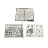
[MAPS]. – Official History of the War. Military Operations Egypt and Palestine. [No place]: Ordnance Survey, [1927-29]. 18 folding maps out of 23...
ENGLISH MAPS & TOPOGRAPHY. A collection of maps of England, including Robert MORDEN (1650-1703).
ENGLISH MAPS & TOPOGRAPHY. A collection of maps of England, including Robert MORDEN (1650-1703). Kent). 340 x 615 mm. Published in Camden’s Britan...