Filtered by:
- Primary Category,
- Category
- List
- Grid
This auctioneer has chosen to not publish their results. Please contact them directly for any enquiries.
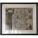

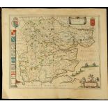
MERCATOR, Gerard (1512 -94). Eboracum Lincolnia, Derbia, Staffordia, Notinghamia, Lecestria,
MERCATOR, Gerard (1512 -94). Eboracum Lincolnia, Derbia, Staffordia, Notinghamia, Lecestria, Rutlandia, et Norfolcia. 370mm x 420mm. [Amsterdam]: ...
CARY, John (1754-1835). Cary's Reduction of his large Map of England and Wales, with part of
CARY, John (1754-1835). Cary's Reduction of his large Map of England and Wales, with part of Scotland; Comprehending the whole of the Turnpike Ro...
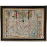
SPEED, John (1552-1629). Suffolk described and divided into Hundreds, The Situation of the fayre
SPEED, John (1552-1629). Suffolk described and divided into Hundreds, The Situation of the fayre towne Ipswich shewed with the Armes of the most n...
![SAXTON, Christopher (c. 1540 – c. 1610). Suffolcias Comitatus Juius Populi. [London]: [1607-37?].](https://portal-images.azureedge.net/auctions-2017/srchis10333/images/95674707-55e4-43fc-aea4-ea4eb8b84fe0.jpg?w=155&h=155)
SAXTON, Christopher (c. 1540 – c. 1610). Suffolcias Comitatus Juius Populi. [London]: [1607-37?].
SAXTON, Christopher (c. 1540 – c. 1610). Suffolcias Comitatus Juius Populi. [London]: [1607-37?]. 380mm x 305mm. Hand-coloured. (Browned). Framed ...
![[MONTANUS, Arnoldus?] Nova Virgine Tabula. [Amsterdam?]: [1671]. 355mm x 285mm. (Lightly browned,](https://portal-images.azureedge.net/auctions-2017/srchis10333/images/4555b2e9-4897-4e11-ff2b-36f1f350a0a6.jpg?w=155&h=155)
[MONTANUS, Arnoldus?] Nova Virgine Tabula. [Amsterdam?]: [1671]. 355mm x 285mm. (Lightly browned,
[MONTANUS, Arnoldus?] Nova Virgine Tabula. [Amsterdam?]: [1671]. 355mm x 285mm. (Lightly browned, old tape marks outside the plate mark). An impo...
CARY, John (1754 – 1835). Cary's New Map of England and Wales, with part of Scotland. London: J.
CARY, John (1754 – 1835). Cary's New Map of England and Wales, with part of Scotland. London: J. Cary, 1794. Folio. General map, (without sheet 63...
Willem Janszoon Blaeu (1571-1638). Essexia Comitatus. Amsterdam; Blaeu, c. 1648 (16,7 x 20,7
WillemJanszoon Blaeu (1571-1638). Essexia Comitatus. Amsterdam; Blaeu, c. 1648 (16,7x 20,7 inch / 41,6 x 52 cm). Original copper-engraving and han...
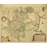
HOUNDIUS, Hendrik (1597-1651). A General Plot and Description of the Fennes and Surounded Grounds in
HOUNDIUS, Hendrik (1597-1651).A General Plot and Description of the Fennes and Surounded Grounds in the FixeCounties of Norfolke, Suffolke, Cambri...
ARROWSMITH, A. A Map of Lower Egypt From Various Surveys Communicated by Major Bryce and Other
ARROWSMITH, A. A Map of Lower Egypt From Various Surveys Communicated by Major Bryce and Other Officers. London: A. Arrowsmith, 1807. 1280mm x 16...
![[SARDINIA], Trieste: Presso l’Autore, mid to late 18th century (49, 5 x 50, 8 cm). Engraved and](https://portal-images.azureedge.net/auctions-2017/srchis10333/images/8f7bc849-4efa-410d-c6d6-2bcc40895eb4.jpg?w=155&h=155)
[SARDINIA], Trieste: Presso l’Autore, mid to late 18th century (49, 5 x 50, 8 cm). Engraved and
[SARDINIA], Trieste:Presso l’Autore, mid to late 18th century (49, 5 x 50, 8 cm). Engraved andhand-coloured (Slight spotting and minor chipping). ...
The New Encyclopaedia Atlas. With An Alphabetical Index of the Latitudes and Longitudes of 30,000
The New Encyclopaedia Atlas. With An Alphabetical Index of the Latitudes and Longitudes of 30,000 Places. Small Folio. 35 coloured maps (occasiona...
![ALLEN (Joseph & Rowe R.). [Allen’s English Atlas, being a set of County Maps on Cards...]. [](https://portal-images.azureedge.net/auctions-2017/srchis10333/images/a42d8e2f-3c11-44d9-cb10-3acf3bdff6a7.jpg?w=155&h=155)
ALLEN (Joseph & Rowe R.). [Allen’s English Atlas, being a set of County Maps on Cards...]. [
ALLEN (Joseph & Rowe R.). [Allen’s English Atlas, being a set of County Maps on Cards...]. [London, Joseph Allen & Robert Rowe, 1811]. 90mm x 25mm...
BUXTON, Thomas. The African Slave Trade and Its Remedy. London: John Murray, 1840. 8vo. 1 folding
BUXTON, Thomas. The African Slave Trade and Its Remedy. London: John Murray, 1840. 8vo. 1 folding map, [with]: the Prospectus of the Society for...