
Filtered by:
- Category,
- Item Type
- List
- Grid
A subscription to the Price Guide is required to view results for auctions ten days or older. Click here for more information
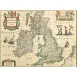

A tinted map of the British Isles, Hondius (Henricus), Magnae Britanniae Et Hiberniae Tabula, 41.5 x
A tinted map of the British Isles, Hondius (Henricus), Magnae Britanniae Et Hiberniae Tabula, 41.5 x 52 cm See illustrationReport by RBThere is a ...
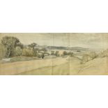
John Baptist Malchair (1729-1812), A Distant View of Oxford from the Abingdon Road at the distance
John Baptist Malchair (1729-1812), A Distant View of Oxford from the Abingdon Road at the distance of a Mile and three quarters just above South H...
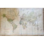
A German map of the world, on linen, 1923, 90 x 144 cm some fold, tears and creases. Some staining/
A German map of the world, on linen, 1923, 90 x 144 cmsome fold, tears and creases. Some staining/foxing to top right hand corner, some loss to ju...

A Betts's Portable Terrestrial Globe, compiled from the Latest and Best Authorities, British
A Betts's Portable Terrestrial Globe, compiled from the Latest and Best Authorities, British Empire coloured red, with original Betts's Patent Por...

A Facsimile of the Ordnance Surveyors' Drawings of the London Area 1799-1808, and other assorted
A Facsimile of the Ordnance Surveyors' Drawings of the London Area 1799-1808, and other assorted maps (all unframed)