Filtered by:
- Sale Section,
- Item Type
- List
- Grid
A subscription to the Price Guide is required to view results for auctions ten days or older. Click here for more information
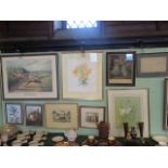

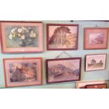
A collection of coloured prints and water colours, to include: a botanical study, monogrammed and dated 1985, an antique prospect of Houghton Park...
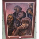
Nisbet (Catherine? American), a congregation of mournful ladies in thoughtful repose, oil on board,
Nisbet (Catherine? American), a congregation of mournful ladies in thoughtful repose, oil on board, signed with surname only, 59cm x 44cm.

A Chinese watercolour on silk, depicting a river landscape with mountainous rear, together with four other picture, including: facsimile maps, wat...
A Horev of Paris, screen silk printed scarf, designed by Serge Poliakoff (1906 - 1969), 82cm x 83cm.
A Horev of Paris, screen silk printed scarf, designed by Serge Poliakoff (1906 - 1969), 82cm x 83cm.
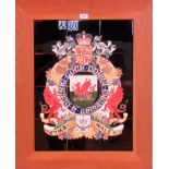
A composite pottery tile panel with a tube lined and enamelled coat of arms for Wales, 61cm x 46cm.
A composite pottery tile panel with a tube lined and enamelled coat of arms for Wales, 61cm x 46cm.

Two Fores's Coaching Recollections, plates II & III, engraved by J Harris after C C Henderson.
Two Fores's Coaching Recollections, plates II & III, engraved by J Harris after C C Henderson.
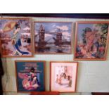
A collection of mostly wool work pictures of Oriental ladies, Tower Bridge and cottage garden,
A collection of mostly wool work pictures of Oriental ladies, Tower Bridge and cottage garden, together with a watercolour of a Mediterranean stre...
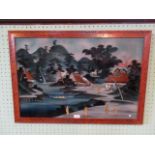
An early 20th century Japanese reverse painting and collage on glass, depicting a Japanese riverscape with Mount Fuji to the back ground, 49cm x 7...
A collection of seven colour prints and watercolours, one after Paul Nash.
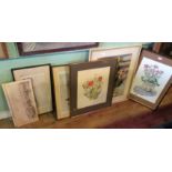
W Birkett, still life study of tulips, oxide daisies and dandelions, watercolour, signed and dated 1972, together with still life studies and Hoga...
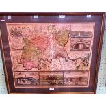
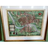
A map of London produced in Germany in the late 18th century. The map is 50cm x 59cm, carefully hand-coloured and in good complete condition. On...
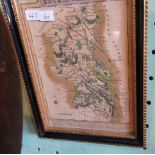
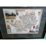
A map of Buckinghamshire by the cartographer John Speed, dated 1610. The map is 39cm x 51cm, beautifully hand-coloured and embellished with two t...
A map of Edinburgh from circa 1850. The map is 36cm x 51cm, carefully hand-coloured and in good complete condition. It has an appropriate modern...
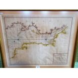
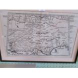
A scarce map of the Bristol Channel, produced in France hence the title Carte de La Riviere Saverne.
A scarce map of the Bristol Channel, produced in France hence the title Carte de La Riviere Saverne. The date is probably late 18th century and t...
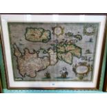
A rare map of Roman Britain by Abraham Ortelius, produced in 1595. It is 36cm x 52cm, carefully hand-coloured and in good complete condition. It...
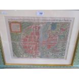
A rare map of Brightstowe which we know as Bristol. It comes from Civitates Orbis Terrarum, which was produced in 1572 in Cologne by George Braun...
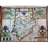
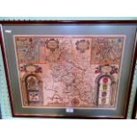
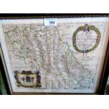
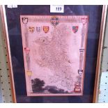
Map of Rutland from 1642 by John Speed, the 17th century cartographer. The map is 42cm x 53cm, the paper containing the contemporary watermark, t...
Map of Gloucestershire from 1758 by Emanuel Bowen. The map is 18cm x 20cm, carefully hand-coloured and in good complete condition. It has an app...
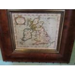
Map of England, Scotland and Ireland from 1688 by Robert Morden. The map is 12cm x 13.5cm, carefully hand coloured and in good complete condition...
Map of Buckinghamshire from circa 1850. The map is 13.5cm x 9cm, carefully hand-coloured and in good complete condition. It has an appropriate m...
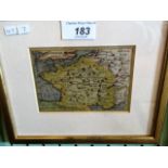
Map of France from the 17th century. The map is 6.5cm x 12cm, carefully hand-coloured and in good complete condition. It has an appropriate mode...
A rare map of the county of Northampton which appeared in Richard Blome's Britannia (London 1673).
A rare map of the county of Northampton which appeared in Richard Blome's Britannia (London 1673). The map is 31cm x 25cm, carefully hand-coloure...
A map of European Settlements in the East Indies by Thomas Kitchin, which was probably included in Abbe Raynal's 1784 publication 'A Philosophical...
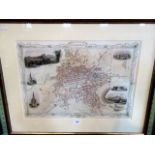
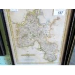
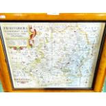
Map of Hertfordshire from circa 1840 by Thomas Moule. The map is 20.5cm x 26.5cm, carefully hand-coloured and in good complete condition. It has...
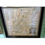
Map of Oxfordshire from circa 1800 by Hohn Cary. The map is 21cm x 26cm, carefully hand-coloured and in good complete condition. It has an appro...
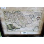
A map of Kent, probably from the late 18th century. The map is 14cm x 22cm, carefully hand-coloured and in good complete condition but with a lit...
Map of Buckinghamshire from circa 1820 by Thomas Moule. The map is 27cm x 20cm, carefully hand-coloured and in good complete condition. It has a...
A map of Hertfordshire based on the surveys of Christopher Saxton and John Norden, which appeared in Camden's Britannia. The map, which is early ...
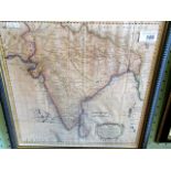
A map of India from the Descriptio Orbis Antiqui, published in Nurenberg in 1720 by Christopher Weigel. This is a rare item. The map is 31cm x 4...
A map of Paris produced in Germany and is probably by Sebastian Munster. Taken from a book as the page numbers 102/103 would indicate. This is a...