Refine your search
Filtered by:
- Category,
- Item Type
- List
- Grid
A subscription to the Price Guide is required to view results for auctions ten days or older. Click here for more information
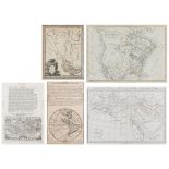

Five (5) Maps of the World and North America, including Hondius. 1st item: Typus Orbis Terrarum English folio edition map, engraved by Jodocus Hon...
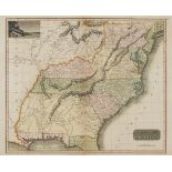
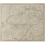
"Map of the Southern Provinces of the United States", drawn and engraved by N. R. Hewitt, published by John Thomson, Edinburgh, John Cumming, Dubl...
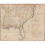
Joseph Purcell: A MAP OF THE STATES OF VIRGINIA, NORTH CAROLINA, SOUTH CAROLINA, AND GEORGIA; Comprehending the SPANISH PROVINCES of EAST AND WEST...
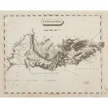
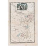
"Tennessee" Map, drawn by Samuel Lewis, engraved by Alexander Lawson, published by John Conrad and Company, Philadelphia, 1804. From "A New And El...
John Reid Kentucky Map, 1795
Map of the State of Kentucky with the Adjoining Territories 1795 engraved by A. Anderson, published by John Reid, New York, 1796. From "The Americ...
Scarce untitled Civil War era map of the area between Washington, D.C. and Mount Vernon by James Tuthill, lithographed by Herline and Hensel, Phil...
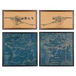
Four (4) World War I related items - two (2) tactical maps of France and two (2) field gun schematics. 1st-2nd items: Two (2) tactical maps of Fra...