
Filtered by:
- Lots with images only,
- Category
- List
- Grid
This auctioneer has chosen to not publish their results. Please contact them directly for any enquiries.

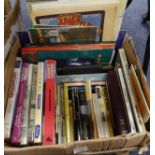
MAPS. Ordnance Survey Atlas of England & Wales, quarter Inch to the Mile, printed at the Ordnance
MAPS. Ordnance Survey Atlas of England & Wales, quarter Inch to the Mile, printed at the Ordnance Survey Office, 1922, worn binding. Together with...
W G Blackie-The Comprehensive Atlas & Geography of the World, comprising an extensive series of
W G Blackie-The Comprehensive Atlas & Geography of the World, comprising an extensive series of MAPS, numerous illustrations and colour engravings...
RAILWAY INTEREST. Esau- The Southern then and Now, pub HRP, 2009. D I Gordon A Regional History of
RAILWAY INTEREST. Esau- The Southern then and Now, pub HRP, 2009. D I Gordon A Regional History of the Railways of Great Britain, Vol 5 Eastern Co...
Topography Local History. MAWSON- The Flyde Region Joint Town Planning Advisory Committee, AMOUNDERNESS, Report to the Flyde Regional Committee, p...
RAILWAY INTEREST. O Holt- A Regional History of the Railways of Great Britain, Volume 10 The North
RAILWAY INTEREST. O Holt- A Regional History of the Railways of Great Britain, Volume 10 The North West, pub David & Charles David St John Thomas,...
CHRISTOPHER SAXTON, PUBLISHED BY JOHN SPEEDE 1610 HAND-COLOURED ANTIQUE MAP 'WORCESTERSHIRE', with
CHRISTOPHER SAXTON, PUBLISHED BY JOHN SPEEDE 1610 HAND-COLOURED ANTIQUE MAP 'WORCESTERSHIRE', with town plan, with five family crests, 15in x 20in...
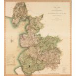
C. SMITH 1801, HAND-COLOURED ANTIQUE MAP, 'A New Map of the County Palatine of Lancashire', 19 1/2in
C. SMITH 1801, HAND-COLOURED ANTIQUE MAP, 'A New Map of the County Palatine of Lancashire', 19 1/2in x 17 1/2in (50 x 45cm), framed, (Provenance b...
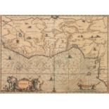
JAN JANSSON 1650, HAND-COLOURED ANTIQUE MAP, 'GUINEA', 10 1/4in x 14 1/4in), (26 x 36cm), framed
JAN JANSSON 1650, HAND-COLOURED ANTIQUE MAP, 'GUINEA', 10 1/4in x 14 1/4in), (26 x 36cm), framed
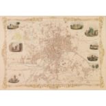
JOHN TALLIS 1851, HAND-COLOURED ANTIQUE TOWN PLAN WITH LATER HAND-COLOURING, 'LEEDS', with eight
JOHN TALLIS 1851, HAND-COLOURED ANTIQUE TOWN PLAN WITH LATER HAND-COLOURING, 'LEEDS', with eight vignette views, 11 1/2in x 17 1/2in (30 x 45cm), ...
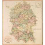
J. CARY 1801, HAND-COLOURED ANTIQUE MAP OF WILTSHIRE, 21in x 19in (54 x 48cm), framed, (Provenance
J. CARY 1801, HAND-COLOURED ANTIQUE MAP OF WILTSHIRE, 21in x 19in (54 x 48cm), framed, (Provenance bought from Michael Morris)
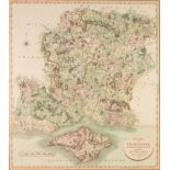
J. CARY 1801, HAND-COLOURED ANTIQUE MAP OF HAMPSDHIRE WITH ISLE OF WIGHT, 21in x 19in (54 x 48cm),
J. CARY 1801, HAND-COLOURED ANTIQUE MAP OF HAMPSDHIRE WITH ISLE OF WIGHT, 21in x 19in (54 x 48cm), framed, (Provenance bought from Michael Morris)
FACSIMILE FROM EAST LOTHIAN DISTRICT LIBRARY OF A SURVEYED BY JAMES HAY AND ENGRAVED BY CHARLES
FACSIMILE FROM EAST LOTHIAN DISTRICT LIBRARY OF A SURVEYED BY JAMES HAY AND ENGRAVED BY CHARLES THOMSON, MUSSELBURGH AND ITS ENVIRONS, a townplan,...
JOHN HARRSION 1787, HAND-COLOURED ANTIQUE MAP OF ESSEX, 13 3/4in x 17in (35 x 4cm), unframed but
JOHN HARRSION 1787, HAND-COLOURED ANTIQUE MAP OF ESSEX, 13 3/4in x 17in (35 x 4cm), unframed but with card, mount and cellophane, (Provenance boug...
C. BOWLES 1785, LATER HAND-COLOURED ANTIQUE MAP OF THE NORTH RIDING OF YORKSHIRE, 9in x 13in (22.5 x
C. BOWLES 1785, LATER HAND-COLOURED ANTIQUE MAP OF THE NORTH RIDING OF YORKSHIRE, 9in x 13in (22.5 x 33cm), with card, mount and cellophane, (Prov...
C. BOWLES 1785, HAND-COLOURED ANTIQUE MAP OF THE WEST RIDING OF YORKSHIRE, 9in x 13in (22.5 x 33cm),
C. BOWLES 1785, HAND-COLOURED ANTIQUE MAP OF THE WEST RIDING OF YORKSHIRE, 9in x 13in (22.5 x 33cm), with card, mount and cellophane, (Provenance ...
JOSHUA ARCHER c. 1845, ANTIQUE MAP, NORTH RIDING OF YORKSHRE, 7in x 9in (18 x 23cm), mounted and
JOSHUA ARCHER c. 1845, ANTIQUE MAP, NORTH RIDING OF YORKSHRE, 7in x 9in (18 x 23cm), mounted and cellophaned, but unframed, (Provenance bought fro...
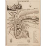
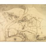
JOHN ROPER FROM A DRAWING BY G. COLE 1832, AN INFORMATIVE TOWN PLAN 'DURHAM' with numbered index
JOHN ROPER FROM A DRAWING BY G. COLE 1832, AN INFORMATIVE TOWN PLAN 'DURHAM' with numbered index to buildings, published in The British Atlas, 9in...
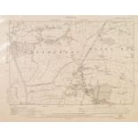
TWO ORDNANCE SURVEY MAPS, LEYLAND Lancashire Sheet 69 S.W. 1931 and BRETHERTON & CROSTON, Lancashire
TWO ORDNANCE SURVEY MAPS, LEYLAND Lancashire Sheet 69 S.W. 1931 and BRETHERTON & CROSTON, Lancashire Sheet 76 N.E. 1929, unframed ...[more]
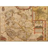
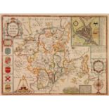
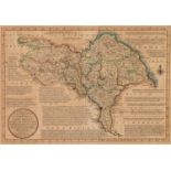
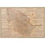
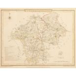
JOHN SPEEDE ANTIQUE HAND COLOURED MAP OF HEREFORDSHIRE With town plan, six heraldic shields and
JOHN SPEEDE ANTIQUE HAND COLOURED MAP OF HEREFORDSHIRE With town plan, six heraldic shields and battle vignette with inscription beneath 15? x 2...
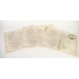
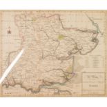
ROBERT MORDEN THREE MATCHING ANTIQUE MAPS OF HEREFORD 15 ½? X 17 ¼? (39.3cm x 43.8cm), overall,
ROBERT MORDEN THREE MATCHING ANTIQUE MAPS OF HEREFORD 15 ½? X 17 ¼? (39.3cm x 43.8cm), overall, unframed and unmounted, (3)
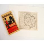
BARTHOLOMEWS CLOTH BACKED AND FOLDING ?CHILDREN?S MAP OF LONDON?, together with an ANTIQUE MAP OF
BARTHOLOMEWS CLOTH BACKED AND FOLDING ?CHILDREN?S MAP OF LONDON?, together with an ANTIQUE MAP OF HEREFORDSHIRE BY BADESLADE and TOMS, 6 ½? x 6 ¾?...
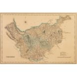
NEELE & SON ANTIQUE HAND COLOURED MAP OF CHESHIRE 11? X 16 ¼? (28cm x 41.2cm) ...[more]
THREE ANTIQUE MAPS: TWO BY JOHN CARY CUMBERLAND, 10 ½? X 8 ¼? (26.6cm x 21cm) WESTMORELAND, hand
THREE ANTIQUE MAPS: TWO BY JOHN CARY CUMBERLAND, 10 ½? X 8 ¼? (26.6cm x 21cm) WESTMORELAND, hand coloured 8 ¼? x 10 ¼? (21cm x 26cm) WESTMORELAN...
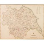
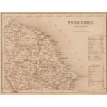
THREE ANTIQUE HAND COLOURED MAPS OF YORKSHIRE: YORKSHIRE, LEWIS: CREIGHTON and STARLING 15 ½? X
THREE ANTIQUE HAND COLOURED MAPS OF YORKSHIRE: YORKSHIRE, LEWIS: CREIGHTON and STARLING 15 ½? X 19 ½? (39.3cm x 49.5cm) YORKSHIRE: PARTS OF EAST A...
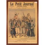
LE PETIT JOURNAL - ILLUSTRATED SUPPLEMENT, FRONT PAGE L'Armee Coloniale, framed together with a
LE PETIT JOURNAL - ILLUSTRATED SUPPLEMENT, FRONT PAGE L'Armee Coloniale, framed together with a complete edition and NINE LOOSE ILLUSTRATED SHEETS...