
Filtered by:
- Category
- List
- Grid
A subscription to the Price Guide is required to view results for auctions ten days or older. Click here for more information
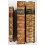

ACROSS AFRICA CAMERON. Published Philip and Son 1885. New edition, full leather prize binding. Sinai
ACROSS AFRICA CAMERON. Published Philip and Son 1885. New edition, full leather prize binding. Sinai and Palestine by Stanley Cheap Edition with m...
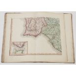
MAP OF SPAIN AND PORTUGAL BY MENKELLE AND P.G. CHANLAIRE. Published by John Stockdale, Picadilly
MAP OF SPAIN AND PORTUGAL BY MENKELLE AND P.G. CHANLAIRE. Published by John Stockdale, Picadilly 1808. This publication houses an index to Mentel...
JAMES WYLD, A FAMILIAR AND PRACTICAL TREATISE ON THE USE OF THE GLOBES. Terrestrial and Celestial
JAMES WYLD, A FAMILIAR AND PRACTICAL TREATISE ON THE USE OF THE GLOBES. Terrestrial and Celestial and the Construction of maps. Privately publish...
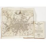
AIKEN J., 'A DESCRIPTION OF THE COUNTRY FROM THIRTY TO FORTY MILES AROUND MANCHESTER', embellished
AIKEN J., 'A DESCRIPTION OF THE COUNTRY FROM THIRTY TO FORTY MILES AROUND MANCHESTER', embellished with seventy three plates, printed for John Sto...
PIGOT'S MANCHESTER AND SALFORD DIRECTORY FOR 1813, with folding map, original calf boards
G.W. BACON. COMMERCIAL AND LIBRARY ATLAS OF THE WORLD, 1908, various colour maps throughout, front
G.W. BACON. COMMERCIAL AND LIBRARY ATLAS OF THE WORLD, 1908, various colour maps throughout, front board and pine strip detached, binding reasonab...
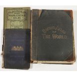
READERS DIGEST 'Great World Atlas', and 'Complete Atlas of the British Isles', various 'A.A.',
READERS DIGEST 'Great World Atlas', and 'Complete Atlas of the British Isles', various 'A.A.', Publications including 'The Illustrated Road Book o...
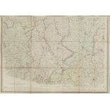
CHARLES FREDERICK CHEFFINS (1807-1862) (Assistant to George Stephenson) TWO LINEN BACKED FOLDING
CHARLES FREDERICK CHEFFINS (1807-1862) (Assistant to George Stephenson) TWO LINEN BACKED FOLDING MAPS showing the proposed route of The Grand Ju...
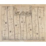
JOHN OGILBY, ANTIQUE MAP 'The Road from London to Carlisle' 14 1/4" x 16 1/2" (36.2cm x 42cm)
JOHN OGILBY, ANTIQUE MAP 'The Road from London to Carlisle' 14 1/4" x 16 1/2" (36.2cm x 42cm) ...[more]
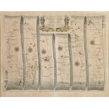
JOHN OGILBY ANTIQUE HAND COLOURED ROAD MAP OF LUDLOW TO CHESTER, (a continuation of the road map
JOHN OGILBY ANTIQUE HAND COLOURED ROAD MAP OF LUDLOW TO CHESTER, (a continuation of the road map from Bristol to Chester) 13 ½" x 18" (34.3cm x 45...
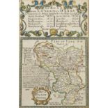
TWO ANTIQUE HAND COLOURED SMALL MAPS 'CHESHIRE' AND 'DARBYSHIRE' Both set beneath an index of roads,
TWO ANTIQUE HAND COLOURED SMALL MAPS 'CHESHIRE' AND 'DARBYSHIRE' Both set beneath an index of roads, 'York to West Chester' and 'London to Darby' ...