
Filtered by:
- Category
3 items
- List
- Grid
A subscription to the Price Guide is required to view results for auctions ten days or older. Click here for more information
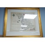

Lot 417
SEVENTEENTH CENTURY MAP 'Lancasthire Palatinatus Angh's Lancaster et Lancashire', anon (Willem
SEVENTEENTH CENTURY MAP 'Lancasthire Palatinatus Angh's Lancaster et Lancashire', anon (Willem Blaue) Hand coloured map 17" x 21 1/4" (43.2cm x ...
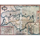
Lot 418
JOHN SPEED ENGRAVED AND HAND COLOURED MAP of Isle of Wight Published by Sudbury and Humbell with
JOHN SPEED ENGRAVED AND HAND COLOURED MAP of Isle of Wight Published by Sudbury and Humbell with text visible verso 15 1/4" x 20" (38.5cm x 51cm...
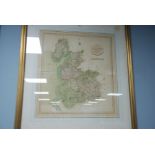
Lot 419
EARLY NINETEENTH CENTURY MAP OF LANCASHIRE John Cary Engraver 1806 Hand coloured 22" x 19" (55.8cm x
EARLY NINETEENTH CENTURY MAP OF LANCASHIRE John Cary Engraver 1806 Hand coloured 22" x 19" (55.8cm x 48.2cm)