Filtered by:
- Category
- List
- Grid
A subscription to the Price Guide is required to view results for auctions ten days or older. Click here for more information
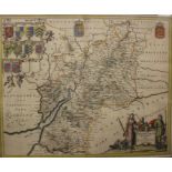

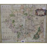
Gloucestershire - Blaeu (Johannes), Glocestria Ducatus Vulgo Glocester Shire, c.1648 engraved map
Gloucestershire - Blaeu (Johannes), Glocestria Ducatus Vulgo Glocester Shire, c.1648 engraved map with contemp. hand colouring, decorative cartou...
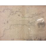
Bristol - ‘The Severn or Channell of Bristoll’ Capt. Greenvile Collins, 1693 this map shows the
Bristol - ‘The Severn or Channell of Bristoll’ Capt. Greenvile Collins, 1693 this map shows the Bristol Channel, which divides Wales and the weste...
'German Democratic Republic - Political map', pub. VEV Hermann Haack. and 'Strassenkarte von
'German Democratic Republic - Political map', pub. VEV Hermann Haack. and 'Strassenkarte von Sudost-Europa', 'NORD', dated 1943, German map, (2)
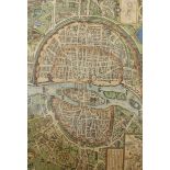
A map of London, framed and glazed, 51.5cmx 66cm
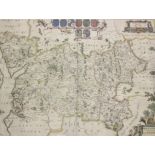
Robert Morden 'Worcestershire' hand coloured map, 36.5cm x 44cm
A quantity of assorted maps to include various French maps, a 20th Century map id Riyadh, European
A quantity of assorted maps to include various French maps, a 20th Century map id Riyadh, European Atlas editions etc
A 'Hantshire' and 'Barkshire' hand coloured map, 47cm x 57cm
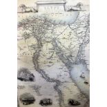
A map of Egypt, John Tallis and Company, London and another of Mexico (2)