Filtered by:
- Category,
- Item Type
2 items
- List
- Grid
A subscription to the Price Guide is required to view results for auctions ten days or older. Click here for more information

A group of 17th and 18th century maps and viewsIncluding examples by John Speede, mainly of Hungary and the Continent (7)For further information ...
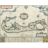
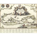
Hondium (Henricum)Mappa Aestivarum Insularum Alias Barmudas (Circa 1630)Hand coloured engraved map 51.5cm wide, 39.5cm high (20in wide, 15 1/2in h...