Refine your search
Filtered by:
- Category,
- Item Type
- List
- Grid
A subscription to the Price Guide is required to view results for auctions ten days or older. Click here for more information
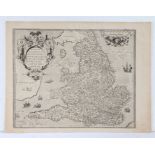

H. Lhuyd, engraved map, England & Wales, circa 1575, "Angliae Regni Florentissimi Nova Descriptio,
H. Lhuyd, engraved map, England & Wales, circa 1575, "Angliae Regni Florentissimi Nova Descriptio, Auctore Humfredo Lhuyd Denbygiense", 55cm x 42....
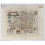
Richard Blome, coloured map engraving, South Wales, 1673, "A generall mapp of South Wales wherein
Richard Blome, coloured map engraving, South Wales, 1673, "A generall mapp of South Wales wherein are the counties of Glamorgan, Carmarden, Pembro...
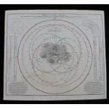
Johann Baptist Homann, "MOTUS IN COELO SPIRALES", coloured celestial chart, with central depiction
Johann Baptist Homann, "MOTUS IN COELO SPIRALES", coloured celestial chart, with central depiction of cherubs on swings, 60cm x 53.5cm

Johann Baptista Homann, coloured celestial chart, "Globi Coelestis in Tabulas Planas Redacti Pars
Johann Baptista Homann, coloured celestial chart, "Globi Coelestis in Tabulas Planas Redacti Pars I", circa 1730, showing Ursa Minor, Ursa Major, ...
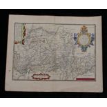
Abraham Ortelius, coloured engraved map "WESTPHALIAE TOTIUS, FINI TIMARVMQVE REGIONUM ACCVRATA
Abraham Ortelius, coloured engraved map "WESTPHALIAE TOTIUS, FINI TIMARVMQVE REGIONUM ACCVRATA DESCRIPTIO", dated 1579 to corner, 57cm x 46cm
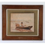
British primitive school, Cornish Fisherman, Falmouth 1907 to the bottom corner, 28cm x 22cm
British primitive school, Cornish Fisherman, Falmouth 1907 to the bottom corner, 28cm x 22cm