Refine your search
Sale Section
- 20th century (3)
- Advertising (5)
- Books (3)
- Clocks (1)
- Furniture (5)
- glass (2)
- Jewellery (3)
- Maps (142)
- Medals (1)
- Militaria (1)
- music (4)
- Oriental (4)
- Pens (5)
- pictures (23)
- Porcelain (2)
- Postcards (1)
- Railway (2)
- Scientific (26)
- Silver (19)
- sporting (20)
- Taxidermy (29)
- Toys and Games (9)
- Tribal (29)
- Walking sticks (3)
- Watches (2)
- Wines and Spirits (6)
- Works of Art (120)
Estimate
Category
- Maps (125)
- Taxidermy & Natural History (34)
- Ethnographica & Tribal Art (33)
- Collectables (27)
- Arms, Armour & Militaria (24)
- Sculpture (19)
- Scientific Instruments (18)
- Books & Periodicals (17)
- Models, Toys, Dolls & Games (15)
- Silver & Silver-plated items (15)
- Sporting Memorabilia & Equipment (13)
- Writing Instruments (12)
- Prints (10)
- Vintage Fashion (9)
- Jewellery (8)
- Metalware (8)
- Wines & Spirits (8)
- Photographs (7)
- Furniture (6)
- Kitchenalia (6)
- Salvage & Architectural Antiques (6)
- Tools (5)
- Watercolours (5)
- Ceramics (4)
- Japanese Works of Art (4)
- Musical Instruments & Memorabilia (4)
- Barometers (3)
- Chinese Works of Art (3)
- Clocks (3)
- Stamps (3)
- Textiles (3)
- Cameras & Camera Equipment (2)
- Lighting (2)
- Oil, Acrylic paintings & Mixed Media (2)
- Watches & Watch accessories (2)
- Bank notes (1)
- Classic Cars, Motorcycles & Automobilia (1)
- Drawings & Pastels (1)
- Glassware (1)
- Islamic Works of Art (1)
Filtered by:
- Item Type
- List
- Grid
A subscription to the Price Guide is required to view results for auctions ten days or older. Click here for more information
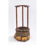

Victorian elephants foot umbrella and stick stand, the mahogany open circular and scroll carved
Victorian elephants foot umbrella and stick stand, the mahogany open circular and scroll carved top above triple turned pilasters and elephants fo...

Taxidermy- preserved alligator, 74cm long

Taxerdermy of a Yellow headed black bird housed in a case, 36cm wide 22cm tall ...[more]

Taxidermy birds housed in a case, to include a parakeet and hummingbird ...[more]

Taxidermy stoat of pale colourings, S. A. Nobbs of Lincoln stamped to the reverse of the case,
Taxidermy stoat of pale colourings, S. A. Nobbs of Lincoln stamped to the reverse of the case, 35cm wide 20cm tall ...[more]

Taxidermy- pair of red deer antlers, on an oak shield backing, 70cm wide

Taxidermy- African Hunting Trophy Cape Buffalo Skull (Syncerus caffer caffer), mid 20th century,
Taxidermy- African Hunting Trophy Cape Buffalo Skull (Syncerus caffer caffer), mid 20th century, large adult horns on cut upper skull, 91cm wide ...

Taxidermy- Silver plate mounted horses hoof inkwell by Peter Spicer, the hinged lid engraved "VIKING
Taxidermy- Silver plate mounted horses hoof inkwell by Peter Spicer, the hinged lid engraved "VIKING 1918-1933", the horseshoe stamped "PETER SPIC...

Taxidermy, Devon & Somerset Stag Hounds, a mounted deer slot, the silver cap London 1931, maker
Taxidermy, Devon & Somerset Stag Hounds, a mounted deer slot, the silver cap London 1931, maker Robert Pringle, engraved "D.&S.S.H FOUND HELEBRIDG...

African Hunting Trophy, Blue Wildebeest (Connochaetes taurinus), mounted with horns to the skull
African Hunting Trophy, Blue Wildebeest (Connochaetes taurinus), mounted with horns to the skull on a shield,47cm wide, 42cm high

Taxidermy: Chital or Axis Deer (Axis axis), circa mid 20th century, six points, from the wall
Taxidermy: Chital or Axis Deer (Axis axis), circa mid 20th century, six points, from the wall 48cm, height 119cm

Taxidermy: Lowland Nyala (Nyala angasii), mid 20th Century, facing right, marked to the back 943/
Taxidermy: Lowland Nyala (Nyala angasii), mid 20th Century, facing right, marked to the back 943/C, from the wall 46cm, height 96cm

Lesser Kudu (Tragelaphus imberbis) mid 20th Century, from the wall 50cm, 86cm high

Taxidermy: Southern Impala (Aepyceros malampus malampus) with a Rowland Ward Certificate of Publication 11th Edition, Owner J Carey-Hughes, from t...

Taxidermy: Peter Spicer, cased Jay on a branch and painted back board, signed pebble to the back
Taxidermy: Peter Spicer, cased Jay on a branch and painted back board, signed pebble to the back left corner, 46cm x 60cm

Taxidermy: cased French partridge, housed in a glazed case, 42cm x 34cm

Taxidermy: cased Barn Owl, 28cm x 39cm

Taxidermy: a cased Tawny owl perched on a branch, 35.5cm x 42cm

Taxidermy: cased Buzzard above a rabbit, 40cm x 55cm

Taxidermy, cased Sparrow Hawk and Green Woodpecker, attributed to James Hutchings, of Aberystwyth,
Taxidermy, cased Sparrow Hawk and Green Woodpecker, attributed to James Hutchings, of Aberystwyth, cased 32cm x 54cm

Taxidermy; Red Squirrels (Sciurus vulgaris) Mounted by George Bazeley, 12 Horsemarket, Northampton, with two squirrels on moss covered plinths, la...
Taxidermy: Ladakh Urial (Ovis vignnei vignei) Mid 20th Century, found in the Indus and Shayok
Taxidermy: Ladakh Urial (Ovis vignnei vignei) Mid 20th Century, found in the Indus and Shayok valleys in Ladakh and neighbouring Gilgit-Baltistan ...

Taxidermy: Indian Blackbuck (Antilope cervicapra), mid 20th Century, from the wall 37cm, 76cm high
Taxidermy: Indian Blackbuck (Antilope cervicapra), mid 20th Century, from the wall 37cm, 76cm high

Taxidermy- fox head, the oak shield with gilt and black lettering "LEDBURY HOUNDS PEPPER SEPT 27TH
Taxidermy- fox head, the oak shield with gilt and black lettering "LEDBURY HOUNDS PEPPER SEPT 27TH 1916", the shield 22.5cm wide, 30.5cm high

Taxidermy long eared owl, modelled on a branch surrounded by foliage, housed in a gilt and ebonised glazed case, 35cm wide, 48cm high ...[more]

Taxidermy - pair of canaries, modelled in a naturalistic setting and under a glass dome, 25cm high
Taxidermy - pair of canaries, modelled in a naturalistic setting and under a glass dome, 25cm high

Taxidermy study of a seagull, modelled on a rocky outcrop with seashells and weed, housed under a
Taxidermy study of a seagull, modelled on a rocky outcrop with seashells and weed, housed under a glass dome and on an ebonised oval plinth base, ...

Taxidermy white fronted goose by F.E. Gunn, labelled to base "White Fronted Goose, Male, 3 years,
Taxidermy white fronted goose by F.E. Gunn, labelled to base "White Fronted Goose, Male, 3 years, Hulvergate 24.2.29", 46cm high

Captain Greenville Collins, "Yarmouth and the Sands about it", hand coloured sea chart, housed in
Captain Greenville Collins, "Yarmouth and the Sands about it", hand coloured sea chart, housed in a gilt and glazed frame, the chart 57cm x 46cm

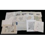
Collection of maps of Huntingdonshire, to include later coloured examples (qty)
Maps to include Lincolnshire, Westmoreland, Northumberland, Cambridgeshire, Durham, Leicestershire, Hertfordshire, Grantham, Cheshire, Isle of Tha...

Remigius Hogenbergius, coloured map of Montgomeri 1578, 45cm x 34cm, coloured map of South Wales,
Remigius Hogenbergius, coloured map of Montgomeri 1578, 45cm x 34cm, coloured map of South Wales, 29.5cm x 23cm, E.S Weller coloured map of Glamor...

Letts. Son & Co Limited two coloured maps of South Wales, black and white engraved map of South-East
Letts. Son & Co Limited two coloured maps of South Wales, black and white engraved map of South-East Wales, engraved map of Monmouthshire with num...

Henry Teesdale, original coloured map engraving, Monmouthshire, T.L. Murray, original coloured map
Henry Teesdale, original coloured map engraving, Monmouthshire, T.L. Murray, original coloured map engraving, Wales, 48cm x 71cm, Edward Weller, f...

Robert Morden, original map engraving, South Wales, 45.5cm x 39cm, Robert Morden, original coloured map engraving, the county of Monmouth, 44.5cm ...

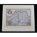
Map of the South east Circuit of the Principality of Wales, Comprising the Counties of Glamorgan,
Map of the South east Circuit of the Principality of Wales, Comprising the Counties of Glamorgan, Brecon & Radnor from an actual survey made in th...

Original coloured map engraving, "Tabi Euopae Continens Albion, Brittaniam et Hiberniam", housed
Original coloured map engraving, "Tabi Euopae Continens Albion, Brittaniam et Hiberniam", housed in a glazed frame, the map 47cm x 41cm ...[more]

Wales maps- A Modern Map of South Wales, A modern Map of North Wales verso, 27.5cm x 22cm, Cary
Wales maps- A Modern Map of South Wales, A modern Map of North Wales verso, 27.5cm x 22cm, Cary coloured map of South Wales, Walpole's New & Compl...

Eman and Thomas Bowen, original coloured map engraving, South Wales Divided into it's Counties,
Eman and Thomas Bowen, original coloured map engraving, South Wales Divided into it's Counties, mounted, the map 33cm wide, 22cm high

Mounted and loose road maps, to include Carmarthen, Glocester, Abingdon, Haverford West, Tiverton,
Mounted and loose road maps, to include Carmarthen, Glocester, Abingdon, Haverford West, Tiverton, nine loose and two mounted (11)

Loose maps, Aberavon, Neath, Kenfig, Glamorganshire (2), Twickenham (6)

Langley & Belch, original coloured map engraving, "LANGLEY'S new MAP of GLAMORGANSHIRE", with
Langley & Belch, original coloured map engraving, "LANGLEY'S new MAP of GLAMORGANSHIRE", with illustration of Caerphilly Castle, mounted, the map ...

Thomas Moule, original coloured map engraving, Monmouthshire, circa 1850, the borders with illustrations of Tintern Abbey, Chepstow Castle and the...

John Luffman, original coloured map engraving, Glamorganshire, published for a new pocket atlas
John Luffman, original coloured map engraving, Glamorganshire, published for a new pocket atlas and geography of England & Wales 1803-1806, mounte...

John Cary, original coloured map engraving, South Wales, published Jan. 1. 1821, mounted, the map
John Cary, original coloured map engraving, South Wales, published Jan. 1. 1821, mounted, the map 10cm wide, 14.5cm high

Thomas Gardner, original coloured map engraving, "The Continuation of the Road from LONDON to St
Thomas Gardner, original coloured map engraving, "The Continuation of the Road from LONDON to St DAVIDS commencing at Abingdon com Berks & Extendi...

Thomas Bowen, original coloured map engraving, "The Road from LONDON to St DAVIDS in Pembroke
Thomas Bowen, original coloured map engraving, "The Road from LONDON to St DAVIDS in Pembroke Shire", mounted, the map 29cm wide, 18cm high

T. Kitchin, original coloured map engraving, "an accurate map of the county of Glamorgan drawn
T. Kitchin, original coloured map engraving, "an accurate map of the county of Glamorgan drawn from an accurate survey by T. Kitchin Geogr", print...

Benjamin Baker, original coloured map engraving, South Wales, for the Universal Magazine of Knowledge and Pleasure published 1791-1797, mounted, w...

Dartons New Miniature Atlas, coloured map engraving circa 1820, mounted with description of Glamorganshire, the map 12.5cm wide, 8.5cm high

John Bill, map engraving, Glamorganshire, circa 1626, the first county maps to have longitude and
John Bill, map engraving, Glamorganshire, circa 1626, the first county maps to have longitude and latitude marked, mounted, the map, 12.5cm wide, ...

John Seller, hand coloured map engraving, Glamorganshire, from "Anglica Contracta", circa 1695,
John Seller, hand coloured map engraving, Glamorganshire, from "Anglica Contracta", circa 1695, mounted, the map 15.5cm wide, 12.5cm high ...[mo...

Ordinance Survey map, Glamorgan, circa 1830, sheet 37, 96cm wide 67cm high

Humphry Lloyd original coloured map engraving of Wales, 56.5cm x 48cm, later reproduction of the
Humphry Lloyd original coloured map engraving of Wales, 56.5cm x 48cm, later reproduction of the same map, 60cm x 47cm (2)

Opening pages to a Welsh dictionary "Geiriadur Ysgrythyrol", with folding map of the world, published Bala 1836 ...[more]
Christopher Saxton, coloured map engraving, Glamorganshire, amended by P Lea, with cartouches
Christopher Saxton, coloured map engraving, Glamorganshire, amended by P Lea, with cartouches depicting Cardyfe and Landaffe, mounted the map 49cm...

J. Blaeu, coloured map engraving, Wales, circa 1660, "Wallia principatus vulgo Wales", mounted,
J. Blaeu, coloured map engraving, Wales, circa 1660, "Wallia principatus vulgo Wales", mounted, 50.5cm x 39cm ...[more]

Coloured map engraving, Glamorgan, circa 1875, mounted, 30.5cm x 23cm

Coloured map engraving, South Wales, circa 1842, with depiction of Oystermouth Castle & Harbour,
Coloured map engraving, South Wales, circa 1842, with depiction of Oystermouth Castle & Harbour, mounted, the map 26cm x 20.5cm ...[more]

Coloured map engraving "CRUCHLEY'S RAILWAY AND STATION MAP OF SOUTH WALES SHOWING ALL THE RAILWAYS &
Coloured map engraving "CRUCHLEY'S RAILWAY AND STATION MAP OF SOUTH WALES SHOWING ALL THE RAILWAYS & NAMES OF THE STATIONS, ALSO THE TURNPIKE, GEN...