Refine your search
Filtered by:
- Category
- List
- Grid
A subscription to the Price Guide is required to view results for auctions ten days or older. Click here for more information
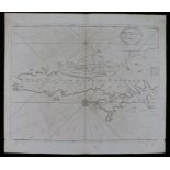

Shetland Islands, circa 1693, The South part of the Isles of Shetland, dedicated and presented to
Shetland Islands, circa 1693, The South part of the Isles of Shetland, dedicated and presented to Mr. John Colson, Teacher of Mathematician in Lon...
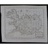
Iceland, Jacques Nicolas Bellin (1703-1782) circa 1758, Carte De L'Islande, pour fervir ala Continuation de I'Histoire generale des Voyages, Dress...
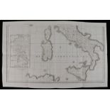
Mediterranean, Samuel John Neele (1758-1824) Sardinia and Sicily, Published by John Stockdale,
Mediterranean, Samuel John Neele (1758-1824) Sardinia and Sicily, Published by John Stockdale, Piccadilly 12 March 1800, 90cm x 56cm ...[more]
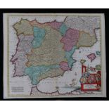
Spain, Justus Danckerts (1635-1701) Accuratis sima Totius Regini Hispania Tabula Per Iustinum
Spain, Justus Danckerts (1635-1701) Accuratis sima Totius Regini Hispania Tabula Per Iustinum Danckerts, hand coloured map, 61cm x 51cm ...[more]

John Cary (1754-1835) A New Map of Asia from the Latest Authorities, published 1806, printed for
John Cary (1754-1835) A New Map of Asia from the Latest Authorities, published 1806, printed for J. Cary Engraver & Map seller No 181 Strand 1st 1...

John Cary (1754-1835) A New Map of China from the Latest Authorities, published 1806, printed for J.
John Cary (1754-1835) A New Map of China from the Latest Authorities, published 1806, printed for J. Cary Engraver & Map seller No 181 Strand 1st ...

John Cary (1754-1835) A New Map of Chinese & Independent Tartary from the Latest Authorities,
John Cary (1754-1835) A New Map of Chinese & Independent Tartary from the Latest Authorities, published 1806, printed for J. Cary Engraver & Map s...
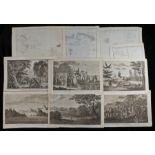
Captain Cook, a collection of plates from George William Andersons A New, Authentic, and Complete
Captain Cook, a collection of plates from George William Andersons A New, Authentic, and Complete Collection of Voyages Round the World, undertake...
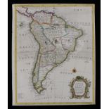
South America, R.W. Seale, 18th Century, with all the European Settlements & Whatever else is
South America, R.W. Seale, 18th Century, with all the European Settlements & Whatever else is remarkable from the latest and best observations, ha...
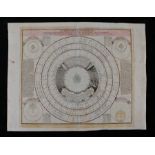
Celestial map, Johann Gabriel (1677-1750) circa 1742, Astronomia Comparativa, hand coloured, 72cm x
Celestial map, Johann Gabriel (1677-1750) circa 1742, Astronomia Comparativa, hand coloured, 72cm x 55cm ...[more]