Filtered by:
- Show only bulk lots,
- Sale Section
- List
- Grid
A subscription to the Price Guide is required to view results for auctions ten days or older. Click here for more information


Collection of architectural plans, to include L & NWR. Haydon Square, plan of boiler seating,
Collection of architectural plans, to include L & NWR. Haydon Square, plan of boiler seating, etc, (qty)
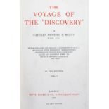
Captain Robert Scott, The voyage of `Discovery` 1st edition, London: Smith, Elder & Co., 1905.
Captain Robert Scott, The voyage of `Discovery` 1st edition, London: Smith, Elder & Co., 1905. 8vo, 2 volumes, original blue cloth gilt
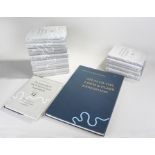
The Journals of the Lewis & Clark Expedition, Volumes 1 to 13, second printing 1999, University of
The Journals of the Lewis & Clark Expedition, Volumes 1 to 13, second printing 1999, University of Nebraska Press, (13)
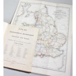
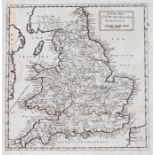
Samuel Lewis, A Topographical Dictionary of England and Wales, 1845 Atlas volume
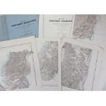
Map of Western Palestine, from surveys conducted for the Committee of the Palestine Exploration
Map of Western Palestine, from surveys conducted for the Committee of the Palestine Exploration fund, by Lieuts C.R. Condur and H.H. Kitchener R.E...
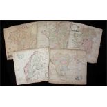
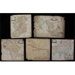
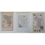
Five maps to include Thomas Kitchin, maps of Ireland, Turkey in Europe with Hungary, Sweden,
Five maps to include Thomas Kitchin, maps of Ireland, Turkey in Europe with Hungary, Sweden, Denmark, Norway, Finland, Germany and a map by John B...
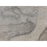
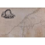
William Faden, Plan of the City and Environs of Quebec with it's siege and blockade from the 8th
William Faden, Plan of the City and Environs of Quebec with it's siege and blockade from the 8th December 1775 to 13th May 1776, published 1776, 6...
Le Sage, Le Sage's Historical, Genealogical, Chronological & Geographical Atlas, with maps, leather bound
Maps of Ireland, to include Dublin Bar, 1911, East Coast of Ireland, also together with a map of
Maps of Ireland, to include Dublin Bar, 1911, East Coast of Ireland, also together with a map of Norway The Naze to the North Cape and Port Baltic...
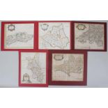
Robert Morden, five maps of Sussex, Dorset, Buckinghamshire, Durham, and South Wales. Printed area
Robert Morden, five maps of Sussex, Dorset, Buckinghamshire, Durham, and South Wales. Printed area 36.5 cm x 42.5cm approximately (5)
Thomas Kitchin, maps, The West Indies, the East Indies, Asia and Africa, (4)
William Faden, A map of the inhabited part of Canada from the French survey's with the frontiers
William Faden, A map of the inhabited part of Canada from the French survey's with the frontiers of New York and New England from the large survey...
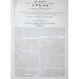
Atlas Geographique, dresse sous la direction du conseil Royal de l'instruction publique pour l'usage
Atlas Geographique, dresse sous la direction du conseil Royal de l'instruction publique pour l'usage des colleges, Paris 1829, with maps, together...
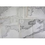
Maps of Ireland, to include Clonakilty 1851, Bantry Bay, Dungarvan Harbour, Castle Haven, Wexford
Maps of Ireland, to include Clonakilty 1851, Bantry Bay, Dungarvan Harbour, Castle Haven, Wexford Harbour and Courtmacsherry, (6)
New map of the rivers & sea coasts of England, 17th / 18th Century, 29cm x 31cm
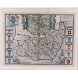
John Speede map of Suffolk, 17th Century, with town map of Ipswich, including frame 67.5cm x 54.5cm
John Speede map of Suffolk, 17th Century, with town map of Ipswich, including frame 67.5cm x 54.5cm
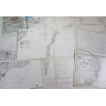
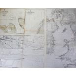
Maps of England, to include Outer Gabbard, 1919, Whitby Harbour, Bridlington Bay, Air Ministry map
Maps of England, to include Outer Gabbard, 1919, Whitby Harbour, Bridlington Bay, Air Ministry map of the English Channel, RAF edition England Sou...
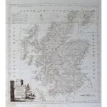
Thomas Kitchin map of Scotland, 18th Century, 39cm x 46cm
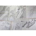
Maps of Scotland, to include Isle of Skye, Lochs Buy, Arisaig Harbour, Kyle Rhea, Frith of Lorn,
Maps of Scotland, to include Isle of Skye, Lochs Buy, Arisaig Harbour, Kyle Rhea, Frith of Lorn, Colonsay and Oronsay and Loch Killisport, (7)
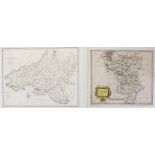
Robert Morden, Darbyshire, 1690, together with A map of South Wales, John Cary, 1805, (2)
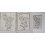
Derbyshire, three maps of Derbyshire, John Cary 1805, P.P. Burdett 1789 and John Cary 1823, (3)
Derbyshire, three maps of Derbyshire, John Cary 1805, P.P. Burdett 1789 and John Cary 1823, (3)
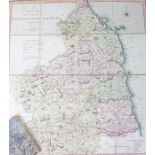
Map of the County of Northumberland, by C. Smith, London, 1804, 46cm wide, contained in the original
Map of the County of Northumberland, by C. Smith, London, 1804, 46cm wide, contained in the original wallet
Herman Moll map of Derbyshire, circa 1724, together with Thomas Kitchin Derbyshire, 1748 and Richard
Herman Moll map of Derbyshire, circa 1724, together with Thomas Kitchin Derbyshire, 1748 and Richard Blome Darbie, 1673, (3)
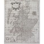
Robert Morden map of Scotland, late 17th / early 18th Century, 39cm x 48cm
Maps of Ireland, to include Lough Swilly New Edition 1914, together with Kinsale Harbour, 1902
Maps of Ireland, to include Lough Swilly New Edition 1914, together with Kinsale Harbour, 1902 edition, Mulroy Bay and Lough, Bantry Bay 1912 and ...
Robert Morden, Hampshire, late 17th Century 44cm x 38cm