Refine your search
Filtered by:
- Category,
- Creator / Brand
- List
- Grid
A subscription to the Price Guide is required to view results for auctions ten days or older. Click here for more information
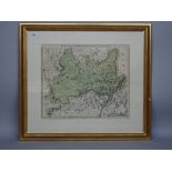

A map by Johann Baptist HOMANN: Circuli Preroviensis Pars Australis. 48cm x 58cm within mount, partly hand-coloured, decorative strapwork title,...
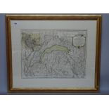
A map by Philippe BUACHE: Carte du Lac de Geneve . . . 52cm x 67cm within mount, partly hand-coloured, decorative cartouche title, inset plan o...
Three maps by Emanuel BOWEN: South American, framed and glazed : Paraguay, Rio de la Plata (etc); Peru, and the Country of the Mazones; Brasil....
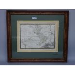
A map by Matthieu SEUTTER: La Plus Grande Parti de la Manche, qu'i contient les Cotes D'Angleterre et celles de France . . . 51cm x 59cm, hand...
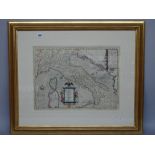
A map by W. BLAUE: Sabavdia Ducatus. Savoye. 38cm x 50cm within mount, hand-coloured, armorial cartouche title, Amsterdam, (ca. 1635), framed an...
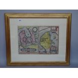
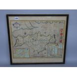
A map by Abraham ORTELIUS: Daniae Regni Typus. Cornelius Antoniades Descripsit: together with (on same sheet), Cimbricae Chersonesi nunc Ivtiae ...
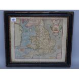
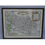
A map by (Christopher SAXTON / William KIP): Englalond Anglia Anglosaxonum Heptarchia. 31cm x 38cm, hand-coloured, decorated cartouche title, s...
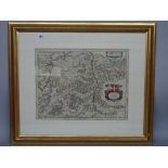
A map by Philipp CLUVER: Italia Antiqua . . . 37cm x 50cm, hand-coloured, pictorial strapwork dedication, engraved text within strapwork border...
A map by F. DE WIT: Regni Norvegia . . . 60cm x 50cm within mount, hand-coloured, pictorial cartouche title, some engraved text, (Amsterdam, ca...
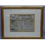
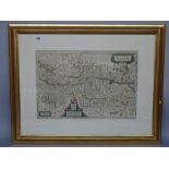
A map by (Johannes BLAUE): Ivtia, olim Cimbrica Chersonesvs. 45cm x 59cm within mount, hand-coloured, pictorial cartouche title and elaborate pi...
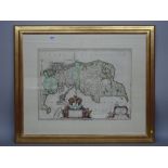
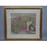
A map by Wolfgang LAZIUM: Austriae Descrip. 36cm x 49cm within mount, hand-coloured, cartouche strapwork title and scale bar, (? Antwerp, 1595),...
A map by Abraham ORTELIUS: (Tuscany, part of), Corsica, Marcha Anconae, on a single sheet, 34cm x 49cm, hand-coloured, strapwork titles, (Antwerp...
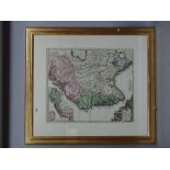
A map by Johann Baptist HOMANN: Dominii Veneti cum Vicinis Parmae mutinae mantuae et Mirandol . .
A map by Johann Baptist HOMANN: Dominii Veneti cum Vicinis Parmae mutinae mantuae et Mirandol . . . 50cm x 59cm within mount, hand-coloured, pi...
A map by W. BLAEU: Austria Archiducatus, auctore Wolfgango Lazio. 37cm x 54cm within mount, hand-coloured, decorative cartouche title, engraved ...
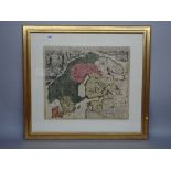
A map by Giovani CASSINI: L'America Secondo le ultime osservazioni Divisa ne' suoi Stati Principali. 35cm x 48cm within inset mount, coloured in ...
A map by John SPEED: Wight Island, 38cm x 50cm, hand-coloured, inset plans of Newport and Southampton, decorated cartouche title, English text on...
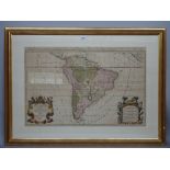
A map by Alexis - Hubert JAILLOT: Amerique Meridionale . . . , 57cm x 88cm within mount, hand-coloured, pictorial cartouche and detailed headli...
A map by Alexis-Hubert JAILLOT: Nova Scandinaviae Tabulae . . . 52cm x 61cm within mount, hand-coloured, elaborate pictorial cartouche title, s...
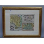
A map by Abraham ORTELIUS: Poictou: Pictonum Vicinarum Que Regionum Fidiss Descriptio . . .
A map by Abraham ORTELIUS: Poictou: Pictonum Vicinarum Que Regionum Fidiss Descriptio . . . 42cm x 55cm, hand-coloured, pictorial cartouche tit...
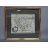
A map by Cornelius Van WYTFLIET: Residuum Continentis cum Adiacentibus Insulis. 21 x 31cms.
A map by Cornelius Van WYTFLIET: Residuum Continentis cum Adiacentibus Insulis. 21 x 31cms., within mount, engraved strapwork title, (Louvain, 15...
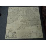
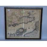
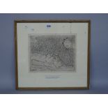
A map by R.W. SEALE: England and Ireland . . . with the Coast of France from Calais to Brest . .
A map by R.W. SEALE: England and Ireland . . . with the Coast of France from Calais to Brest . . . folded on linen, 149 x 152cms., some outli...