Filtered by:
- Sale Section,
- Category
- List
- Grid
A subscription to the Price Guide is required to view results for auctions ten days or older. Click here for more information
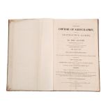

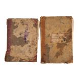
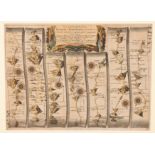
JUVENILE : A Complete Course of Geography, by means of instructive Games, Invented by Abbe Gaultier.
JUVENILE : A Complete Course of Geography, by means of instructive Games, Invented by Abbe Gaultier. 50 pages. 14 large hand coloured double-page ...
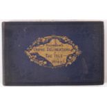
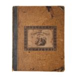
BRANNON'S Graphic Delineations of the most prominent objects in The Isle of Wight. 30 steel engraved plates. Oblong large 8vo. Original blue clot...
FRASER,
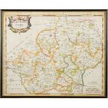
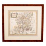
FRASER, Robert - General View of the County of Devon with Observations on the means of its Improvement, quarter cloth, hinges cracked, slim 4to, 1...
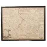
LYSONS, D & S, Magna Britannia... Devonshire, 2 vols., later cloth, 4to, double page map of Devon, plan of Exeter, 3 maps, 29 plates, 1822.
ROSCOE, Thomas : Wanderings and Excursions in South Wales; including Scenery of the River Wye. Org.
ROSCOE, Thomas : Wanderings and Excursions in South Wales; including Scenery of the River Wye. Org. worn and faded cloth with many loose plates. S...
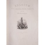
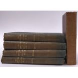
WRIGHT, G.N & BUCKINGHAM, L.F.
WRIGHT, G.N & BUCKINGHAM, L.F.A - Belgium The Rhine, Italy, Greece, and the Shores and Islands of the Mediterranean : IN 48 ORIGINAL PARTS, Engrav...
HARRIS,
HARRIS, John - Astronomical Dialogues Between a Gentleman and a Lady ; Wherein the Doctrine of the Sphere, Uses of the Globes, and the Elements of...
HERBARIUM :Thirty- seven well presented examples of dried grasses, not stuck down exhibited in linen backed marbled boards, each with it's Ms refe...
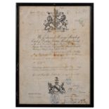
PASSPORT: " We Edward Henry Stanley, Earl of Derby ... request and require in the name of Her Majesty, all those whom it may concern to allow Wi...
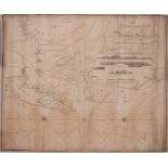
PLAN OF BOMBAY HARBOUR: " A New and Accurate Chart of Bombay Harbor. Draw from the Latest Authorities for William Heather." Large uncoloured chart...
![BLAEU, Jan - Devonia vulgo Devon-Shire : [Devon] and coloured map, 495 x 390 mm. Latin text.](https://portal-images.azureedge.net/auctions-2023/bearne10124/images/c11cc58f-5d35-4192-bfa6-aff801204ba1.jpg?w=155&h=155)
BLAEU, Jan - Devonia vulgo Devon-Shire : [Devon] and coloured map, 495 x 390 mm. Latin text.
BLAEU, Jan - Devonia vulgo Devon-Shire : [Devon] and coloured map, 495 x 390 mm. Latin text. Framed and double glazed. c1645.
BOWEN, Eman - Somersetshire Divided into Hundreds ... map with original outline hand colouring.
BOWEN, Eman - Somersetshire Divided into Hundreds ... map with original outline hand colouring. 330 x 225 mm. F & G. * From Atlas Anglicanus, c177...
CARY, John - A New Map of Africa, from the latest authorities. Engraved map with typical Cary outline hand colouring and wash borders. From the Ne...
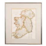
CARY, John - A New Map of Ireland. Divided into Provincies and Counties. Hand coloured map. Size: 400 x 490 mm. F & G. c1810.
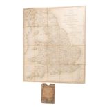
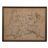
CARY, John - Cary's Reduction of his Large Map of England and Wales, with part of Scotland : Folding map with outline colouring mounted on linen i...
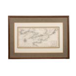
CHART: A Correct Chart of the English and St. George's Channels, with the adjacent Coasts. 18th century black and white engraved map. 375 x 190 mm...
COLLINS, Captain Greenville - hand coloured sea chart : TORBAY//SOUTH DEVON . size : 565 x 445 mm, highly decorative chart depicting in one quarte...
DOWER, J : A Short Atlas of Modern Geography : 33 double -page coloured maps Tall 8vo. c1840s.
DOWER, J : A Short Atlas of Modern Geography : 33 double -page coloured maps Tall 8vo. c1840s. With - Butler, Samuel, An Atlas of Modern Geograph...
![JANSSON, Jan - [ CHESHIRE ] Cestria Comitatus Palatinus.](https://portal-images.azureedge.net/auctions-2023/bearne10124/images/4d828545-9180-4c47-acb9-aff80107780f.jpg?w=155&h=155)
JANSSON, Jan - [ CHESHIRE ] Cestria Comitatus Palatinus. The Countre Palatine of Chester : hand coloured map, size : 480 x 360 mm, f & g, c1644. *...
![KEULEN, Joannes van - Pas-caert van de Canaei ... [ English Channel ] seventeenth century.](https://portal-images.azureedge.net/auctions-2023/bearne10124/images/b9b4b577-18c6-421e-bf67-aff8012098dc.jpg?w=155&h=155)
KEULEN, Joannes van - Pas-caert van de Canaei ... [ English Channel ] seventeenth century. hand coloured sea chart. 555 x 495 mm. Published in Ams...
![KIP, William - Devoniae Comitatus Vulgo Denshyre : ... [Devon]. Hand coloured map. 330 x 290mm.](https://portal-images.azureedge.net/auctions-2023/bearne10124/images/e6853be8-2d6c-432e-ab0c-aff801209a35.jpg?w=155&h=155)
KIP, William - Devoniae Comitatus Vulgo Denshyre : ... [Devon]. Hand coloured map. 330 x 290mm.
KIP, William - Devoniae Comitatus Vulgo Denshyre : ... [Devon]. Hand coloured map. 330 x 290mm. f & g. first edition. 1607. ...[more]
![KIP, William - Sussexia [SUSSEX] uncoloured map, 390 x 220mm. n.d. c1600s.](https://portal-images.azureedge.net/auctions-2023/bearne10124/images/01342ec5-18be-4ea2-ae71-aff801209c13.jpg?w=155&h=155)
KIP, William - Sussexia [SUSSEX] uncoloured map, 390 x 220mm. n.d. c1600s. With - KIP, William - Norfolciae [NORFOLK] Uncoloured Map, 385 x 270m...
![KIP, William - Warwici [Warwickshire] : hand coloured map. 350 x 290 mm. f & G. c1637.](https://portal-images.azureedge.net/auctions-2023/bearne10124/images/103dd97d-7802-4643-83be-aff80120a6e1.jpg?w=155&h=155)
KIP, William - Warwici [Warwickshire] : hand coloured map. 350 x 290 mm. f & G. c1637. With - Morden, Robert. The West Riding of Yorkshire. Hand ...
LIZARD, W.H ... publisher.
LIZARD, W.H ... publisher. New Edinburgh School Atlas Consisting of 34 Maps, of the different Empires, KIngdoms & States throughout the World. 33 ...
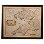
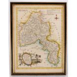
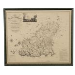
MERCATOR - Cornubia, Devonia, Somersetus, et al. 17th cent. hand coloured map. Size: 455 x 360mm.
MERCATOR - Cornubia, Devonia, Somersetus, et al. 17th cent. hand coloured map. Size: 455 x 360mm. F & G. double-glazed, english text on verso. No...
MORDEN Robert.
MORDEN Robert. A map of Hertfordshire, hand coloured map, 445 x 365mm, framed and glazed KEERE, Van Den, P - Hartforde Shire : hand coloured map, ...
MORDEN, Robert - Hampshire : hand coloured map. Size : 420 x 370mm. In an attractive modern frame, good colouring.
OGILBY, JOHN - The Continuation of the road from London to Barnstaple. Hand coloured strip road map 440 x 320 mm. c1675.
ORBETELLO : " Circumsessio Orbetelli cum praelio naualii inter Hispanos ... 1646."17th Century uncoloured copper engraved map. Size 365 x 290 mm. ...
SANTINI, Francois - Nouvelle Carte De L'Etat De L'Eglise, Dressee sur Celle Du P. Boscovich : engraved map of Rome and District. Size : 610 x 430 ...
SEALE, R. W : A Correct Chart of the English Channel from the No. Foreland to the Land's End : uncoloured copper engraved map. Size : 470 x 380 mm...
![SPEED, John - Barkshire Described: [ Berkshire ] , John Sudbury & George Humble. hand coloured map.](https://portal-images.azureedge.net/auctions-2023/bearne10124/images/2aa24bba-6269-46fd-986c-aff80120dd08.jpg?w=155&h=155)
SPEED, John - Barkshire Described: [ Berkshire ] , John Sudbury & George Humble. hand coloured map.
SPEED, John - Barkshire Described: [ Berkshire ] , John Sudbury & George Humble. hand coloured map. Size : 510 x 380 mm. Framed and double glazed ...
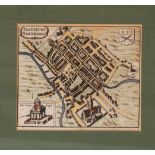
SPEED, John - Salisbury : hand coloured 17th century plan, Size : 130 x 105mm. Taken from Speed's map of the county of Wiltshire these small town ...
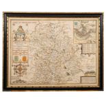
SPEED, John - Shropshyre Described, : hand coloured map. 505 x 375 mm. English text, George Humble.
SPEED, John - Shropshyre Described, : hand coloured map. 505 x 375 mm. English text, George Humble. Subdued colouring. F & G. c1627.
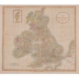
SPEED, John : The Kingdome of England. Hand coloured map, 510 x 380mm. Minor damaged to lower centre fold. John Sudbury & George Humble. 1611. F &...
WILKINSON, Robert - A General Atlas, being a Collection of Maps of the World and Quarters the principal Empires and Kingdoms &co : Engraved vignet...