Filtered by:
- Category
- List
- Grid
A subscription to the Price Guide is required to view results for auctions ten days or older. Click here for more information
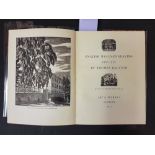

ART & TECHNICS : ... (publisher) English Wood-Engraving 1900-1950 by Thomas Balston 1900-1950, org.
ART & TECHNICS : ... (publisher) English Wood-Engraving 1900-1950 by Thomas Balston 1900-1950, org. cloth backed marbled boards, 4to, neat contemp...

ALDINGTON, Richard - Death of a Hero : cloth (no d/w), 8vo, Chatto & Windus, first ed, 1929.
ALDINGTON, Richard - Death of a Hero : cloth (no d/w), 8vo, Chatto & Windus, first ed, 1929. With 3 others by Aldington, and one other.(5)

PEACOCK, W ...
PEACOCK, W ... (publisher) A Compendious Geographical Dictionary : 6 folding maps with outline hand colouring, cont. red morocco, 12mo, 1795. With...
BORLASE,
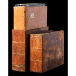
BORLASE, William - Observations on the Ancient and Present State of the Islands of Scilly : 4 engraved plates bound at the rear inc. the large pan...
CARY, John - Cary's Six Sheet map of England and Wales. With Part of Scotland. on which are carefully laid down all the direct and principal cross...
CATHERALL, T - Views in North Wales : org. flexible cloth soiled, engraved title-page, 15 steel engraved vignette plates, contents completely loos...
GREENWOOD, C & J - Map of the County of Devon, from an actual survey made in the years 1825 & 1826:, large scale linen backed map in two ( North...

ORDNANCE SURVEY : a good collection of Ordnance Survey maps, GWR publications and West Country guide books.(box)

TORQUAY VIEWS : Besley's Torquay and Neighbourhood, 12 steel engraved plates, org. cloth, oblong 8vo, n.d. Rock, Views of Torquay, 8 steel engrave...

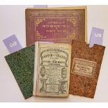
TUNNICLIFF, William - A Topographical Survey of the Counties of Hants, Wilts, Dorset, Somerset,
TUNNICLIFF, William - A Topographical Survey of the Counties of Hants, Wilts, Dorset, Somerset, Devon, and Cornwall : Commonly called the Western ...

TUNNICLIFF, William - A Topographical Survey of the Counties of Hants, Wilts, Dorset, Somerset,
TUNNICLIFF, William - A Topographical Survey of the Counties of Hants, Wilts, Dorset, Somerset, Devon, and Cornwall : Commonly called the Western ...
SOWERBY, John E & JOHNSON, C.
SOWERBY, John E & JOHNSON, C. Pierpoint - British Wild Flowers : colour plates showing numerous examples on each plate, org. green cloth, 4to, Joh...
BARNSTAPLE & BIDEFORD : ...
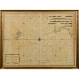
BARNSTAPLE & BIDEFORD : ... A chart of the North East Coast of Devonshire between Hartland Point and Combe-Martin. Including the Bar and Ports of ...
BETTS'S : New Itinerant and Commercial map of England & Wales, on which the various lines of Railroad ... large folding hand coloured map, in 24 ...

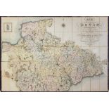
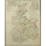
BOWEN, Emanuel - An Accurate Map of Devon Shire Divided into its Hundreds: hand coloured map,
BOWEN, Emanuel - An Accurate Map of Devon Shire Divided into its Hundreds: hand coloured map, size 670 x 520 mm, light staining, Carington Bowles,...
CARTO-BIBLIOGRAPHY : Shirley, Rodney W, Early Printed Maps of the British Isles 1477-1650 : cloth in d/w, 4to, Antique Atlas Publications, 1991. W...
CARTO-BIBLIOGRAPHY : Shirley, Rodney W, The Mapping of the World. Early printed world maps 1472-1700 : cloth in d/w, stout folio, Holland Press, 1...
CARY, John - Cary's New Map of England and Wales, with part of Scotland : ... (etc), maps with org. hand colouring, in original red morocco wall...
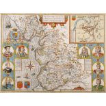
EBDEN, William : Laurie's New Map of the County Palatine of Lancaster, Divided into Hundreds the Mail Direct & Principal Cross Roads ... (etc). Ha...
GREENWOOD, C & J/ Pringle, George - Map of the County of Somerset, from an actual survey made in the years 1820 & 1821:, large scale map with full...
JOHNSTON, Alex.
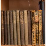
JOHNSTON, Alex. Keith - Handy Royal Atlas : 45 double-page maps with outline colouring, half morocco boards detached, folio, 1868. With two modern...
LEWIS, S (publisher) - A Map of England and Wales Divided into Counties, Parliamentary Divisions & Dioceses: ... [etc] 3 ex. 4 parts. WITH - Dugda...
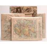
MAP JIGSAWS : 4 jigsaws published by George Philip, The London Geographical Institute, 1900 ? With - Shirley, Rodney W, Printed Maps of the Britis...
MOLL, Herman - A New Description of England and Wales: 44 ex. ? county maps, half calf worn oblong folio, lacks all before the map of Cornwall whi...
ORDNANCE SURVEY : ...
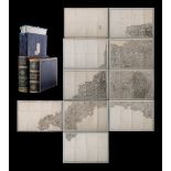
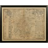
ORDNANCE SURVEY : ... CORNWALL and parts of West Devon - large uncoloured map folding in to 84 sections in 10 sheets mounted on linen, in attracti...
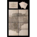
ORDNANCE SURVEY : The second part of the general survey of England and Wales. Containing the whole of DEVON and a proportion of the adjoining coun...
PRICE, John - A Chart of the Chops of the Channel, to the South of Scilly Islands; containing the West Coast of Cornwall and the Scilly Islands: h...
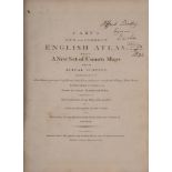
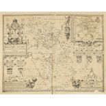
SPEED, John - The Theatre of the Empire of Great-Britain:... Together with a Prospect of the most Famous Parts of the World, viz. Asia, Africa, E...
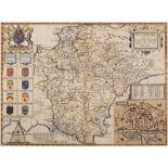
SPEED, John - Devonshire With Excester Described : hand coloured map, published by John Sudbury & John Humble, size 505 x 370 mm, framed and doubl...
SPEED, John - Wiltshire : uncoloured map, size 515 x 390mm, published by John Sudbury & George Humble, English text on verso, LAID DOWN, f & g, c...
SPEED, John : twenty-one maps of Great Britain Counties. Most are in a very fragile state or are quite defective. For a serious restoration projec...