Refine your search
Sale Section
Remove filter- Travel Topography and Local History (8)
Estimate
Category
Remove filter- Maps (8)
Filtered by:
- Sale Section,
- Category
- List
- Grid
A subscription to the Price Guide is required to view results for auctions ten days or older. Click here for more information

BORLASE,
BORLASE, William - Observations on the Ancient and Present State of the Islands of Scilly : 4 engraved plates bound at the rear inc. the large pan...
CARY, John - Cary's Six Sheet map of England and Wales. With Part of Scotland. on which are carefully laid down all the direct and principal cross...
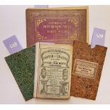
CATHERALL, T - Views in North Wales : org. flexible cloth soiled, engraved title-page, 15 steel engraved vignette plates, contents completely loos...
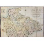
GREENWOOD, C & J - Map of the County of Devon, from an actual survey made in the years 1825 & 1826:, large scale linen backed map in two ( North...

ORDNANCE SURVEY : a good collection of Ordnance Survey maps, GWR publications and West Country guide books.(box)

TORQUAY VIEWS : Besley's Torquay and Neighbourhood, 12 steel engraved plates, org. cloth, oblong 8vo, n.d. Rock, Views of Torquay, 8 steel engrave...

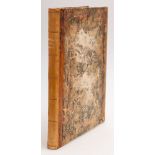
TUNNICLIFF, William - A Topographical Survey of the Counties of Hants, Wilts, Dorset, Somerset,
TUNNICLIFF, William - A Topographical Survey of the Counties of Hants, Wilts, Dorset, Somerset, Devon, and Cornwall : Commonly called the Western ...

TUNNICLIFF, William - A Topographical Survey of the Counties of Hants, Wilts, Dorset, Somerset,
TUNNICLIFF, William - A Topographical Survey of the Counties of Hants, Wilts, Dorset, Somerset, Devon, and Cornwall : Commonly called the Western ...