Filtered by:
- Category,
- Creator / Brand
- List
- Grid
A subscription to the Price Guide is required to view results for auctions ten days or older. Click here for more information
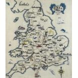

A vintage embroidered 'Map of England & Wales', showing the individual counties and the local
A vintage embroidered 'Map of England & Wales', showing the individual counties and the local industry, 50 by 39cm, glazed and framed, 60 by 49cm....
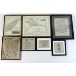
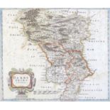
A group of 17th, 18th and 19th century small maps, comprising 'Shropshire' by John Seller, 12 by
A group of 17th, 18th and 19th century small maps, comprising 'Shropshire' by John Seller, 12 by 15cm, glazed and framed, 17 by 19cm, 'Nottingha S...
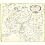
After Robert Morden (British, 1650-1703): a map of Huntingdonshire, hand coloured, published by
After Robert Morden (British, 1650-1703): a map of Huntingdonshire, hand coloured, published by Swale, Awnsham and Churchill, 35.5 by 41.5cm, glaz...
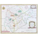
After Robert Morden (British, 1650-1703): a map of Rutland, 'Comitatus Rotelandiae Tabula Nova &
After Robert Morden (British, 1650-1703): a map of Rutland, 'Comitatus Rotelandiae Tabula Nova & Aucta', hand coloured, published by Swale, Church...
After Robert Morden (British, 1650-1703): a map of Darbyshire, hand coloured, published by Swale,
After Robert Morden (British, 1650-1703): a map of Darbyshire, hand coloured, published by Swale, Awnsham and Churchill, 36 by 42cm, mounted, glaz...
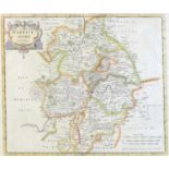
After Robert Morden (British, 1650-1703): a map of Warwickshire, hand coloured, published by
After Robert Morden (British, 1650-1703): a map of Warwickshire, hand coloured, published by Swale, Awnsham and Churchill, 36 by 42.5cm, mounted, ...