Refine your search
Filtered by:
- Category,
- Creator / Brand
4 items
- List
- Grid
A subscription to the Price Guide is required to view results for auctions ten days or older. Click here for more information
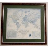

"The Howard Vincent Map of the British Empire" 1924 edition, 53.5cm x 61.5cm and 76cm x 83cm (frame)
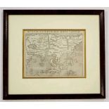
Rare Sebastian Münster (1488 – 1552) map "India Extrema XIX Nova Tabula", printed Basle, 1540, 25.5cm x 33.9cm and 53.5cm x 61cm (frame) The first...
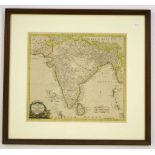
Thomas Kitchin (1718–1784) hand coloured map "New Map of Indostan or East Indies agreeable to the lateft Authorities", published London circa 1770...
Lot 1566
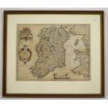
Johann (Jan) Jansson (1588-1664) map
Johann (Jan) Jansson (1588-1664) map "Hibernia Regnum Vulgo Ireland", Amsterdam circa 1640, hand coloured engraving, 38.2cm x 50.3cm and 60cm x 70...