Filtered by:
- Category,
- Item Type
4 items
- List
- Grid
A subscription to the Price Guide is required to view results for auctions ten days or older. Click here for more information
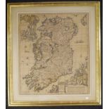

Carolus Allard hand tinted map of Ireland c.1733 'Hyberniae Regni in Provincias Ultoniam Connacham, Lageniam, Momoniama divisi Tebula Accuratissim...
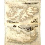
Vintage framed 'Falkland Islands' map framed map of 'Falkland Islands and Patagonia,' in two sections within 1 framed image, illustrated with vig...
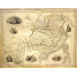
Vintage 'China and Burmah' framed map possibly a reprint of the original map, published circa 1870s, with 6 vignettes of Chinese scenes to border,...
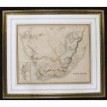
Framed Stanford Geographic Map of South Africa marked as drawn by Stanford Geographical Establishment, London, printed by A. Fullarton & co, Edinb...