Filtered by:
- Category,
- Item Type
- List
- Grid
A subscription to the Price Guide is required to view results for auctions ten days or older. Click here for more information
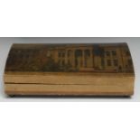

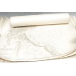
A 19th century named-view tooled and printed card domed rectangular box, the cover with a view of
A 19th century named-view tooled and printed card domed rectangular box, the cover with a view of Salters' Hall, London, engraved by W. Wallis aft...
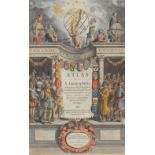
Dutch School (second-quarter, 17th century), the allegorical title-page from volume I of the
Dutch School (second-quarter, 17th century), the allegorical title-page from volume I of the scarce first English edition of the Mercator-Hondius ...
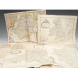
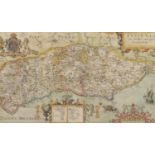
A collection of 17th, 18th and 19th century British national and county maps, including John
A collection of 17th, 18th and 19th century British national and county maps, including John Speed (1552-1629), two county maps: Cumberland (Cumbr...

After Henricus Hondius II (1597-1651), America Septenrionalis, hand-coloured 20th century restrike, 45.5cm x 53.5cm, (1); another similar, after J...
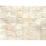
Cartography - a World War I German trench map, Stand der Stellungen vom 18.9.18, 1444, Ausgabe B; an
Cartography - a World War I German trench map, Stand der Stellungen vom 18.9.18, 1444, Ausgabe B; an Ordnance Survey map, edition of 1921, Warwic...
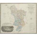
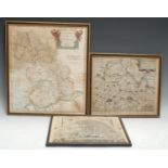
Christopher Greenwood (1786-1855) and John Greenwood (fl.1821-1840), Map of the County of Derby,
Christopher Greenwood (1786-1855) and John Greenwood (fl.1821-1840), Map of the County of Derby, from an Actual Survey made in the Years 1824 & 18...
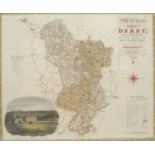
Christopher Greenwood (1786-1855) and John Greenwood (fl.1821-1840), Map of the County of Derby,
Christopher Greenwood (1786-1855) and John Greenwood (fl.1821-1840), Map of the County of Derby, from an Actual Survey made in the Years 1824 & 18...
Emanuel Bowen (1694 - 1767) and John Owen (fl. 1720-1764), after John Ogilby (1600-1676), six
Emanuel Bowen (1694 - 1767) and John Owen (fl. 1720-1764), after John Ogilby (1600-1676), six various county maps: Derbyshire, Leicestershire, Bed...
Emanuel Bowen, a coloured map, An Improved map of the Counties of Cumberland and Westmoreland,
Emanuel Bowen, a coloured map, An Improved map of the Counties of Cumberland and Westmoreland, engraved vignette of The North Prospect of the Cath...
![John Speed (1552-1629), [The British Islands], four maps on one sheet: Holy Island, Farne Islands,](https://portal-images.azureedge.net/auctions-2021/bamfor10735/images/4971135e-b293-4f0b-8d30-ad2e00f01e59.jpg?w=155&h=155)
John Speed (1552-1629), [The British Islands], four maps on one sheet: Holy Island, Farne Islands,
John Speed (1552-1629), [The British Islands], four maps on one sheet: Holy Island, Farne Islands, Guernsey, and Jersey, first edition, London: Jo...
![John Speed (1552-1629), a county map of the West Riding of Yorkshire, [London: 1627], hand-](https://portal-images.azureedge.net/auctions-2021/bamfor10735/images/f8363828-bd69-443b-92f9-ad2e00f01f6d.jpg?w=155&h=155)
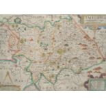
John Speed (1552-1629), a county map of the West Riding of Yorkshire, [London: 1627], hand-
John Speed (1552-1629), a county map of the West Riding of Yorkshire, [London: 1627], hand-coloured engraving, 38.5cm x 52cm
![John Speed (1552-1629), a county map of Yorkshire, [London: 1676], hand-coloured engraving, 39cm x](https://portal-images.azureedge.net/auctions-2021/bamfor10735/images/c4da5559-451e-4d68-980e-ad2e00f02066.jpg?w=155&h=155)
John Speed (1552-1629), a county map of Yorkshire, [London: 1676], hand-coloured engraving, 39cm x
John Speed (1552-1629), a county map of Yorkshire, [London: 1676], hand-coloured engraving, 39cm x 51.5cm
Maritime Cartography - England, a collection of seven Hydrographic Office coastal charts, mixed
Maritime Cartography - England, a collection of seven Hydrographic Office coastal charts, mixed dates but early 20th century restrikes of mid-19th...
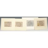
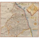
Pieter van den Keere (1571-c. 1646), three miniature county maps or 'Miniature Speeds': Lincolnshire, Northumberland, and Herefordshire, [London: ...
Robert Morden, a coloured map, The County Palatine of Lancaster, 42.5cm x 37cm; another, Robert
Robert Morden, a coloured map, The County Palatine of Lancaster, 42.5cm x 37cm; another, Robert Vaughan after Christopher Saxton, Brecknoc Comitau...
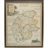
Robert Morden, two page map, Darbyshire (sic), sold by Abel Swale, Awnfham (sic) and John Churchill,
Robert Morden, two page map, Darbyshire (sic), sold by Abel Swale, Awnfham (sic) and John Churchill, London (c.1722) hand coloured engraving, 36cm...
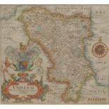
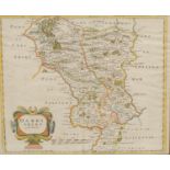
William Hole (d. 1624), after Christopher Saxton (c. 1540 ? c. 1610), a county map of Derbyshire, [
William Hole (d. 1624), after Christopher Saxton (c. 1540 ? c. 1610), a county map of Derbyshire, [London: 1637], hand-coloured engraving, 29.5cm ...
William Hole (d. 1624), after Christopher Saxton (c. 1540 ? c. 1610), a county map of Northumberland, [London: 1637], hand-coloured engraving, 28c...
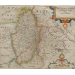
William Kip (1588-1635), after Christopher Saxton (c. 1540 ? c. 1610), county map of Nottinghamshire, [London: 1637], hand-coloured engraving, 27....
William Kip (1588-1635), after Christopher Saxton (c. 1540 ? c. 1610), county map of Staffordshire, [London: 1637], hand-coloured engraving, 27.2c...
William Kip (1588-1635), after Christopher Saxton (c. 1540 ? c. 1610), county map of Sussex, [
William Kip (1588-1635), after Christopher Saxton (c. 1540 ? c. 1610), county map of Sussex, [London: 1610], hand-coloured engraving, 22.5cm x 38c...
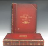
Cartography - Black's General Atlas of the World, New and Revised Edition, Edinburgh: 1884,
Cartography - Black's General Atlas of the World, New and Revised Edition, Edinburgh: 1884, chromolithograph Flags of the All Nations frontispiece...
![Cartography - Cary [(John)], Cary's New Map of England and Wales, with part of Scotland, second](https://portal-images.azureedge.net/auctions-2021/bamfor10735/images/3bd68491-3535-4dce-9922-ad2e00f0672e.jpg?w=155&h=155)
Cartography - Cary [(John)], Cary's New Map of England and Wales, with part of Scotland, second
Cartography - Cary [(John)], Cary's New Map of England and Wales, with part of Scotland, second edition, [London]: 1816, pp: [2] (blank), [vi], 79...