Filtered by:
- Category
- List
- Grid
A subscription to the Price Guide is required to view results for auctions ten days or older. Click here for more information
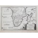

De Fer Nicolas (1646-1720) PARTIE MERIDIONALE Dƒ??AFRIQUE OU SE TROUVENT LA BASSE GUINEE LA CAFRERIE
De Fer Nicolas (1646-1720) PARTIE MERIDIONALE Dƒ??AFRIQUE OU SE TROUVENT LA BASSE GUINEE LA CAFRERIE LE ZANGUEBAR ET Lƒ??ISLE DE MADAGASCAR Map of...
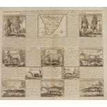
AA VV COUTUMES MOEURS & HABILLEMENS DES PEUPLES QUI HABITENT AUX ENCIRONS DU CAP DE BONNE ESPERANCE Big engraving of 1708 about people and animals...
![[Bonne (Rigobert)] ATLAS DE TOUTES LES PARTIES CONNUES DU GLOBE TERRESTRE Dressé pour L'Histoire](https://portal-images.azureedge.net/auctions-2019/sran10045/images/fdd27a0f-8f07-4237-b390-aa2600a98801.jpg?w=155&h=155)
[Bonne (Rigobert)] ATLAS DE TOUTES LES PARTIES CONNUES DU GLOBE TERRESTRE Dressé pour L'Histoire
[Bonne (Rigobert)] ATLAS DE TOUTES LES PARTIES CONNUES DU GLOBE TERRESTRE Dressé pour L'Histoire Philosophique & Politique des Établissemens & du...
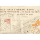
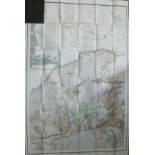
Map GOLD MINES & MINERAL RIGHTS OF THE GREATER WITWATERSRAND & NORTH EAST ORANGE FREE STATE Full
Map GOLD MINES & MINERAL RIGHTS OF THE GREATER WITWATERSRAND & NORTH EAST ORANGE FREE STATE Full colour map mounted on linen and folded ( 860 x110...
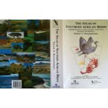
Harrison, JA, DG Allan, LG Underhill, M Herremans, AJ Tree, V Parker, CJ Brown (eds) Atlas of
Harrison, JA, DG Allan, LG Underhill, M Herremans, AJ Tree, V Parker, CJ Brown (eds) Atlas of Southern African Bird Life (2 vols) Colour-printed l...
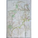
Jeppe, Frederick A Jeppe's Map of the Transvaal - Sheet 2, 1899 Jeppe's Map of The Transvaal - Sheet
Jeppe, Frederick A Jeppe's Map of the Transvaal - Sheet 2, 1899 Jeppe's Map of The Transvaal - Sheet 2. Black pebbled board with map folded into t...
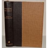
Thomas Phillipps, Arthur Keppel-Jones (Ed.), and E. K. Heathcote. Phillipps, 1820 Settler. Number 81
Thomas Phillipps, Arthur Keppel-Jones (Ed.), and E. K. Heathcote. Phillipps, 1820 Settler. Number 81 of an edition limited to 100 copies, signed b...
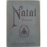
Natal Province. Descriptive Guide and Official Hand-Book. This is a very well produced guide. It
Natal Province. Descriptive Guide and Official Hand-Book. This is a very well produced guide. It contains a vast amount of information on early Na...
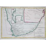
William Paterson Carte de l'extremete meridionale de l'Afrique An uncommon map of Paterson's travels
William Paterson Carte de l'extremete meridionale de l'Afrique An uncommon map of Paterson's travels in southern Africa. The map is from the Frenc...
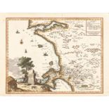
Girolamo Albrizzi Carta Geografica capo di Buona Speranza This attractive map is important for its
Girolamo Albrizzi Carta Geografica capo di Buona Speranza This attractive map is important for its depiction of the second early expansion of the ...
Louis Brion de la Tour Carte du pays des Hottentots Attractively outline coloured French map of
Louis Brion de la Tour Carte du pays des Hottentots Attractively outline coloured French map of the Cape with an inset of the SW corner, based on ...
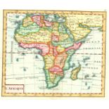
Richard Turner Africa Attractive miniature English map of Africa that was used in schools.The map
Richard Turner Africa Attractive miniature English map of Africa that was used in schools.The map comes from A New and easy introduction to geogra...
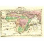
Guiseppe Remondini L'Afrique Attractive colourful and uncommon miniature map of Africa from Venice, 1801. Page 5 in Atlas géographique dressé sur ...
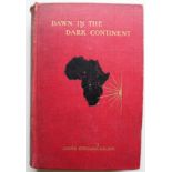
James Stuart DAWN IN THE DARK CONTINENT Africa and its missions - The Duff Missionary Lectures for
James Stuart DAWN IN THE DARK CONTINENT Africa and its missions - The Duff Missionary Lectures for 1902. 400pp plus 16pp. Original cloth. Nine col...
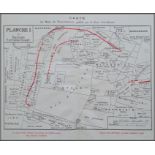
Revue Sud-Africaine Les Mines d'Or du Transvaal (c.1910) "Les Mines d'Or du Transvaal - leur
Revue Sud-Africaine Les Mines d'Or du Transvaal (c.1910) "Les Mines d'Or du Transvaal - leur situation, leurs revenus, leur duree avec une carte d...
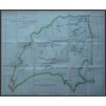
Frederick Dangerfield Map of the South African Republic (1884) Map showing the Boundaries of the
Frederick Dangerfield Map of the South African Republic (1884) Map showing the Boundaries of the South African Republic as defined by Article I of...
Jeppe, Frederick A & Jeppe, C.F.E Jeppe's Map of the Transvaal or S.A.Republic and Surrounding
Jeppe, Frederick A & Jeppe, C.F.E Jeppe's Map of the Transvaal or S.A.Republic and Surrounding Territories Numbers 4-5-6 Jeppe's Map of the Transv...
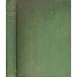
Wagner, Percy Albert The Diamond Fields of Southern Africa Green cloth boards, pp. xxv + 347.
Wagner, Percy Albert The Diamond Fields of Southern Africa Green cloth boards, pp. xxv + 347. Illustrated with black and white plates and maps. Sp...