44
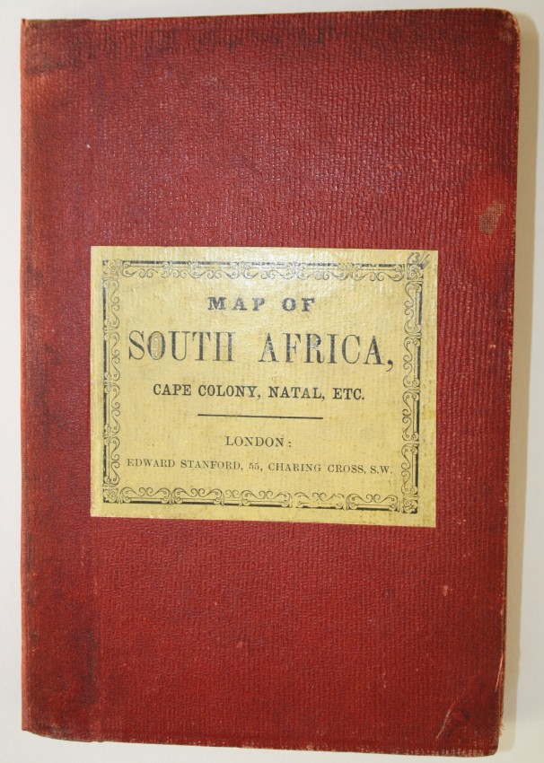
Henry Hall South Africa ZuidAfrica This folded map is by Henry Hall R.E. D whose pioneering
1/4


Description
Henry Hall South Africa ZuidAfrica
Edward Stanford Ltd
London
1858
Very good
73cm x 87 cm
This folded map is by Henry Hall R.E. D whose pioneering contribution to South African Cartography and development of this map only recently has been described, thanks to Elri Liebenberg.
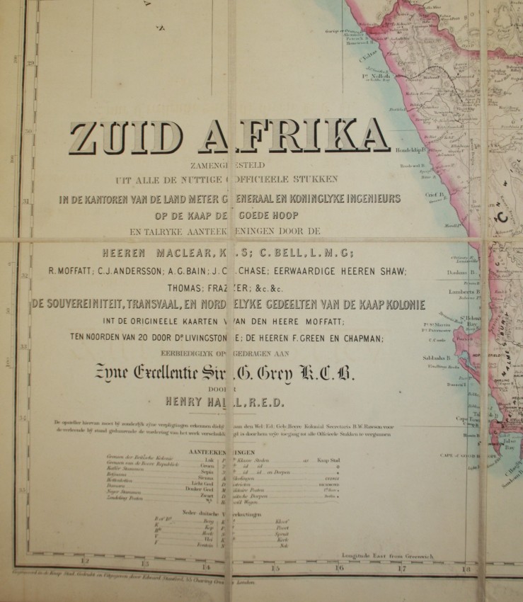
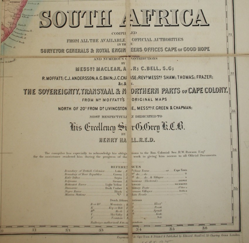
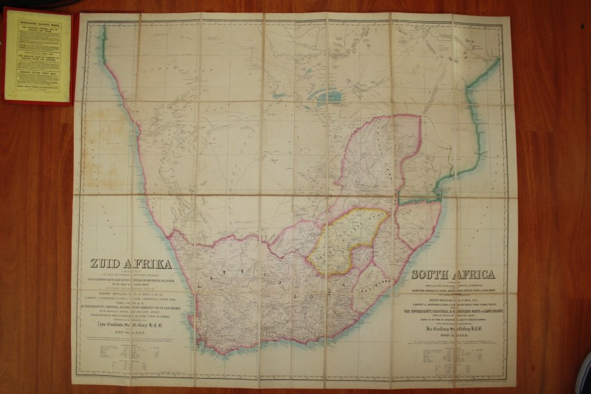
"In 1857, Hall became the first resident cartographer to publish a map of the entire African region south of 16°S. Entitled South Africa , this map was the first of its kind ever to be produced in South Africa as not only the compilation, but also the engraving, printing, colouring and mounting were undertaken locally.
Soon after its publication in South Africa Hall sold the copyright of his map of 1857 to Stanford of London who used the existing plates to publish the complete map under both an English and a Dutch title. However, in 1859 Stanford transferred the area south of 25° S to a conical projection, re-engraved it and published another edition, slightly updated 96 (see Figure 5). Except for the area between 16° S and 26°S which was discarded, all detail on the original 1857 map was retained. Although the actual reason for doing away with the area north of 25 S is not clear, especially as the map border now cuts through the Transvaal, the decision was probably based on the scanty information that was available on these areas. Hall’s map of South Africa of 1857.
What makes Hall’s map of 1857 of particular interest is that it is one of the earliest cartographical documents of southern Africa to include the newly-found Boer republics of the Orange Free State (founded 1854) and the Transvaal (founded 1852), but also the routes followed by the mid-19th century explorers into the vast area further north (of 20° South): Orpen and Shelley (1852), Chapman (1854), Livingstone (1853 and 1856), C.J. Andersson (1853), Moffat and Edwards (1854), and Green and Wahlberg (1856).
By including these routes on his map Hall extended the northern limit of his manuscript maps of 1849 and 1850 with 10° and therewith consciously moved into the unknown parts of south central Africa. Hall was a personal friend of almost all the above-mentioned explorers and a possible explanation for his bold decision is that he considered it his duty and obligation to make their geographical achievements known to the wider public.
The map has been dissected and laid on linen by the publisher; the map is in very good condition, although tears of the linen, between dissected map panels, have been repaired.
As with the edition of the map printed in year before in South Africa (and without the Dutch title), this edition is very seldom in the market. This is a map for the discerning collector.
Reference:
Elri Liebenberg. Providing a tolerably correct map of South Africa : the cartography of Henry Hall. http://history.icaci.org/wp-content/uploads/2016/09/Liebenberg_Elri_2006.pdf
Edward Stanford Ltd
London
1858
Very good
73cm x 87 cm
Auction Details
Shipping
T&Cs & Important Info
Ask seller a question
Henry Hall South Africa ZuidAfrica
Edward Stanford Ltd
London
1858
Very good
73cm x 87 cm
This folded map is by Henry Hall R.E. D whose pioneering contribution to South African Cartography and development of this map only recently has been described, thanks to Elri Liebenberg.
"In 1857, Hall became the first resident cartographer to publish a map of the entire African region south of 16°S. Entitled South Africa , this map was the first of its kind ever to be produced in South Africa as not only the compilation, but also the engraving, printing, colouring and mounting were undertaken locally.
Soon after its publication in South Africa Hall sold the copyright of his map of 1857 to Stanford of London who used the existing plates to publish the complete map under both an English and a Dutch title. However, in 1859 Stanford transferred the area south of 25° S to a conical projection, re-engraved it and published another edition, slightly updated 96 (see Figure 5). Except for the area between 16° S and 26°S which was discarded, all detail on the original 1857 map was retained. Although the actual reason for doing away with the area north of 25 S is not clear, especially as the map border now cuts through the Transvaal, the decision was probably based on the scanty information that was available on these areas. Hall’s map of South Africa of 1857.
What makes Hall’s map of 1857 of particular interest is that it is one of the earliest cartographical documents of southern Africa to include the newly-found Boer republics of the Orange Free State (founded 1854) and the Transvaal (founded 1852), but also the routes followed by the mid-19th century explorers into the vast area further north (of 20° South): Orpen and Shelley (1852), Chapman (1854), Livingstone (1853 and 1856), C.J. Andersson (1853), Moffat and Edwards (1854), and Green and Wahlberg (1856).
By including these routes on his map Hall extended the northern limit of his manuscript maps of 1849 and 1850 with 10° and therewith consciously moved into the unknown parts of south central Africa. Hall was a personal friend of almost all the above-mentioned explorers and a possible explanation for his bold decision is that he considered it his duty and obligation to make their geographical achievements known to the wider public.
The map has been dissected and laid on linen by the publisher; the map is in very good condition, although tears of the linen, between dissected map panels, have been repaired.
As with the edition of the map printed in year before in South Africa (and without the Dutch title), this edition is very seldom in the market. This is a map for the discerning collector.
Reference:
Elri Liebenberg. Providing a tolerably correct map of South Africa : the cartography of Henry Hall. http://history.icaci.org/wp-content/uploads/2016/09/Liebenberg_Elri_2006.pdf
Edward Stanford Ltd
London
1858
Very good
73cm x 87 cm
Online Rare Books, Maps & Prints and Photography Auction
Sale Date(s)
Venue Address
Online only auction
AntiquarianAuctions.com
-
-
United Kingdom
General delivery information available from the auctioneer
Registration on AntiquarianAuctions.com is free of charge.
As a successful bidder you will receive an invoice from the seller after the auction. The seller will only invoice the final selling price. We do not charge a buyer’s premium and no VAT applies.
The buyer pays for shipping and insurance costs which can be requested from the seller before the end of the sale.
Important Information
This is an online only auction. Please visit AntiquarianAuctions.com for further information about a lot and to bid
Terms & Conditions
There is no buyer’s premium charged on AntiquarianAuctions.com
AntiquarianAuctions.com is an online rare book auction website. All lots are listed by recognised booksellers who have been vetted before being accepted to sell on the site. This allows buyers to bid with confidence and ensures that lots are accurately described.
Bidding will begin on 19 January at 4.30 pm (UK time) and ends on 26 January at 4.30 pm (UK time). Please follow the countdown on AntiquarianAuctions.com.
Please visit AntiquarianAuctions.com for further information about a lot and to bid