35
Jacques Bellin Carte Reduite d'une Partie des Costes Occidentales et Meridionales de l'Afrique

Description
Jacques Bellin Carte Reduite d'une Partie des Costes Occidentales et Meridionales de l'Afrique
Dépôt de la Marine
Paris
ca. 1773
Very good
55cm x 89cm
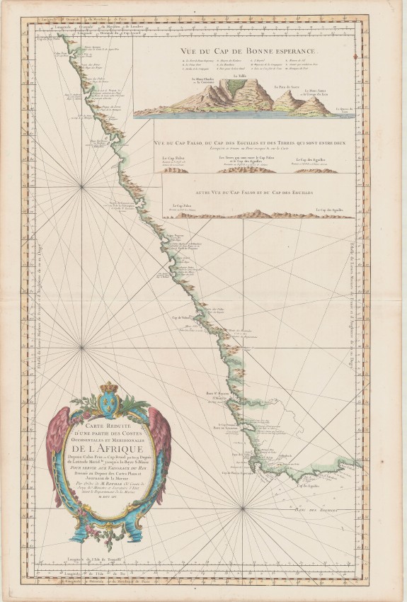
This is one of the more beautiful and historically interesting eighteenth century nautical charts of the south-western coast of Africa (first published in 1754 and here in its quite uncommon third state).
The history of the chart's publication in France covers the transition of that country from Kingdom to Republic, with this example of the chart still reflecting its original Royal mandate but imprint of the author (JN Bellin) erased. Some of the annotations on the prospect of Cape town reflect a cartographic origin back to the 1670s - with English (John Seller) and Dutch (VOC) heritage.
This beautiful and impressive nautical chart was produced by Jacques Nicolas Bellin(1703 - 1772). He was the very productive chief hydrographer and engineer at the 'Depot de la Marine'. The chart first appeared in the 1754 edition of Bellin's massive Hydrographique Français; the chart was also published in The Depot de la Marine's Neptune des côtes occidentales d'Espagne, de Portugal et d'Afrique (even appearing in the 1822 edition).
The copperplate from which the chart was printed is known in five states, with changes made to the imprint and decorative elements - in one state the rhumb lines were increased in number and extended to the borders of the chart, even crossing the vignettes. This example of the chart is in its third state: the crown is present; Bellin's imprint has been erased and the rhumb lines do not cover the vignettes. Bellin died in 1772 and, therefore, it is likely the copper plate was amended posthumously. Later states of the map are more common.
Apart from the usual rhumb lines on nautical charts, the distance scale is in French and English nautical leagues. There are numerous profile views of coastal areas to aid visual navigation and, longitude scales are provided for multiple prime meridians. These meridians are Paris; Tenerife (through the mountain peak, El Pico) and Isle de Fer (Ferro) both in the Canary Islands; London and "Cap Lezard" - the Lizard refers to the most south-westerly cape of Cornwall which had long been used by English navigators.
This chart of the SW coast of Africa extends from Cape Fria in northern Namibia of today to Cape St. Blaise which is near today's Mossel Bay in South Africa. Angra Pequena on the west became the coastal village of Luderitz. St Helena and Saldanha Bays are misshapen; the annotation at Saldanha Bay refers to a French Fort; this was in fact only a flag pole, erected in the seventeenth century, with the French flag that the Dutch promptly removed; and then cut down the pole (in 1668).
The prospect of Table Mountain has been copied from the vignette first published on the sea chart Cape Bona Esperanca in 1675 by John Seller (who obtained plates from the Dutch) - see the blog dated 15 January on this site. That prospect and Bellin's include English names for Devil's Peak and Signal Hill and Lion's head is Sugar Loaf. It also shows two historically important, fortifications that survived only a few years: the original four-sided wood and mud fort, which has been replaced by the Castle about eighty years before the publication of this map, and, near the mouth of the Salt River, the Duijnhoop Redout which had been demolished in the same decade.
The chart is printed in outline colour on two pages of firm paper; the pages have been joined in the middle. The cartouche and vignettes have attractive, recent colouring.
The Antique Map Price record reports the sale of only three examples of this chart in the past 15 years - it is not certain which states of the chart were sold.
References Tooley p.22 and Norwich #279
Dépôt de la Marine
Paris
ca. 1773
Very good
55cm x 89cm
Auction Details
Shipping
T&Cs & Important Info
Ask seller a question
Jacques Bellin Carte Reduite d'une Partie des Costes Occidentales et Meridionales de l'Afrique
Dépôt de la Marine
Paris
ca. 1773
Very good
55cm x 89cm
This is one of the more beautiful and historically interesting eighteenth century nautical charts of the south-western coast of Africa (first published in 1754 and here in its quite uncommon third state).
The history of the chart's publication in France covers the transition of that country from Kingdom to Republic, with this example of the chart still reflecting its original Royal mandate but imprint of the author (JN Bellin) erased. Some of the annotations on the prospect of Cape town reflect a cartographic origin back to the 1670s - with English (John Seller) and Dutch (VOC) heritage.
This beautiful and impressive nautical chart was produced by Jacques Nicolas Bellin(1703 - 1772). He was the very productive chief hydrographer and engineer at the 'Depot de la Marine'. The chart first appeared in the 1754 edition of Bellin's massive Hydrographique Français; the chart was also published in The Depot de la Marine's Neptune des côtes occidentales d'Espagne, de Portugal et d'Afrique (even appearing in the 1822 edition).
The copperplate from which the chart was printed is known in five states, with changes made to the imprint and decorative elements - in one state the rhumb lines were increased in number and extended to the borders of the chart, even crossing the vignettes. This example of the chart is in its third state: the crown is present; Bellin's imprint has been erased and the rhumb lines do not cover the vignettes. Bellin died in 1772 and, therefore, it is likely the copper plate was amended posthumously. Later states of the map are more common.
Apart from the usual rhumb lines on nautical charts, the distance scale is in French and English nautical leagues. There are numerous profile views of coastal areas to aid visual navigation and, longitude scales are provided for multiple prime meridians. These meridians are Paris; Tenerife (through the mountain peak, El Pico) and Isle de Fer (Ferro) both in the Canary Islands; London and "Cap Lezard" - the Lizard refers to the most south-westerly cape of Cornwall which had long been used by English navigators.
This chart of the SW coast of Africa extends from Cape Fria in northern Namibia of today to Cape St. Blaise which is near today's Mossel Bay in South Africa. Angra Pequena on the west became the coastal village of Luderitz. St Helena and Saldanha Bays are misshapen; the annotation at Saldanha Bay refers to a French Fort; this was in fact only a flag pole, erected in the seventeenth century, with the French flag that the Dutch promptly removed; and then cut down the pole (in 1668).
The prospect of Table Mountain has been copied from the vignette first published on the sea chart Cape Bona Esperanca in 1675 by John Seller (who obtained plates from the Dutch) - see the blog dated 15 January on this site. That prospect and Bellin's include English names for Devil's Peak and Signal Hill and Lion's head is Sugar Loaf. It also shows two historically important, fortifications that survived only a few years: the original four-sided wood and mud fort, which has been replaced by the Castle about eighty years before the publication of this map, and, near the mouth of the Salt River, the Duijnhoop Redout which had been demolished in the same decade.
The chart is printed in outline colour on two pages of firm paper; the pages have been joined in the middle. The cartouche and vignettes have attractive, recent colouring.
The Antique Map Price record reports the sale of only three examples of this chart in the past 15 years - it is not certain which states of the chart were sold.
References Tooley p.22 and Norwich #279
Dépôt de la Marine
Paris
ca. 1773
Very good
55cm x 89cm
Online Rare Books, Maps & Prints and Photography Auction
Sale Date(s)
Venue Address
Online only auction
AntiquarianAuctions.com
-
-
United Kingdom
General delivery information available from the auctioneer
Registration on AntiquarianAuctions.com is free of charge.
As a successful bidder you will receive an invoice from the seller after the auction. The seller will only invoice the final selling price. We do not charge a buyer’s premium and no VAT applies.
The buyer pays for shipping and insurance costs which can be requested from the seller before the end of the sale.
Important Information
This is an online only auction. Please visit AntiquarianAuctions.com for further information about a lot and to bid
Terms & Conditions
There is no buyer’s premium charged on AntiquarianAuctions.com
AntiquarianAuctions.com is an online rare book auction website. All lots are listed by recognised booksellers who have been vetted before being accepted to sell on the site. This allows buyers to bid with confidence and ensures that lots are accurately described.
Bidding will begin on 19 January at 4.30 pm (UK time) and ends on 26 January at 4.30 pm (UK time). Please follow the countdown on AntiquarianAuctions.com.
Please visit AntiquarianAuctions.com for further information about a lot and to bid