Refine your search
Filtered by:
- Show only bulk lots,
- Category
2 items
- List
- Grid
A subscription to the Price Guide is required to view results for auctions ten days or older. Click here for more information
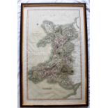

Cary (John) A New Map of the Principality of Wales, Divided into Counties, 1809, 98.5 x 59.5cm (plate size), framed and glazed
Lot 323
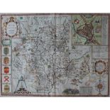
A map of Worcestershire, described by Christopher Saxton, augmented and published by John Speede,
323A map of Worcestershire, described by Christopher Saxton, augmented and published by John Speede,
A map of Worcestershire, described by Christopher Saxton, augmented and published by John Speede, John Sudbury and George Humble, later hand colou...