
Filtered by:
- Category,
- Item Type
- List
- Grid
This auctioneer has chosen to not publish their results. Please contact them directly for any enquiries.
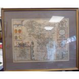

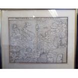
A late 17thC John Speed coloured county map 'Darbieshire' incorporating a birdseye map of Darbye,
A late 17thC John Speed coloured county map 'Darbieshire' incorporating a birdseye map of Darbye, a tower in Buxton and arms of noble families wit...
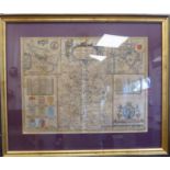
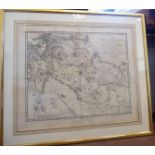
An early 17thC John Speed coloured county map 'Huntington' both Shire and Shire Town with the
An early 17thC John Speed coloured county map 'Huntington' both Shire and Shire Town with the ancient citie Ely described - incorporating the Roya...
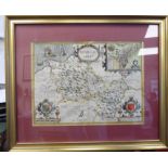
An early 17thC John Speed coloured county map 'Denbighshire' incorporating a scrolled title cartouche, arms, a scale, creatures, a boat on the sea...
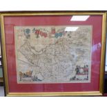
A mid 17thC J Blaeu coloured county map 'Cestria Comitatvs Palatinvs (Cheshire) incorporating
A mid 17thC J Blaeu coloured county map 'Cestria Comitatvs Palatinvs (Cheshire) incorporating pictorial titles and a banner featuring arms of nobl...
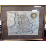
A mid 17thC Gerhard Mercator coloured map 'Anglia Regnum' incorporating a title cartouche and scale
A mid 17thC Gerhard Mercator coloured map 'Anglia Regnum' incorporating a title cartouche and scale with printed text verso 14'' x 18'' framed
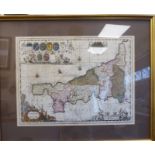
An early 18thC P Shenk and G Valk edition of Johannes Jansson's coloured county map 'Cornubia
An early 18thC P Shenk and G Valk edition of Johannes Jansson's coloured county map 'Cornubia Cornwassia' incorporating a pictorial title cartouch...
A late 18thC Swab,
A late 18thC Swab, Robsahm & Hermelins uncoloured map - 'Charta ofver Herjeadalen' incorporating scales and title information, dated 1796/97 17''...
Sebastian Munster's uncoloured map 'Moderna Evropae Descriptio' 10.5'' x 13.5'' framed