Filtered by:
- Category,
- Item Type
- List
- Grid
A subscription to the Price Guide is required to view results for auctions ten days or older. Click here for more information
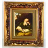

ROSENTHAL; a rectangular porcelain plaque depicting 'The Hermit' after Saloman Koninck, printed
ROSENTHAL; a rectangular porcelain plaque depicting 'The Hermit' after Saloman Koninck, printed marks and titled in German to reverse, 22.7 x 17.8...
![AFTER JOHN SPEEDE; a black and white engraved map, 'The West Ridinge of Yorkeshyre [sic]', folded](https://portal-images.azureedge.net/auctions-2020/adam-p10198/images/13d026d5-1a7d-4c2f-8658-ab59009f4c2b.jpg?w=155&h=155)
AFTER JOHN SPEEDE; a black and white engraved map, 'The West Ridinge of Yorkeshyre [sic]', folded
AFTER JOHN SPEEDE; a black and white engraved map, 'The West Ridinge of Yorkeshyre [sic]', folded and later coloured, plate approx 38 x 51cm, an e...
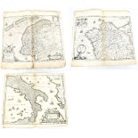
HENRICI HONDÜ; a 17th century black and white map, 'Neapolitanum Regnum', plate approx 42 x 51cm,
HENRICI HONDÜ; a 17th century black and white map, 'Neapolitanum Regnum', plate approx 42 x 51cm, with text verso, 'Metio et Freitag'; a 17th cent...
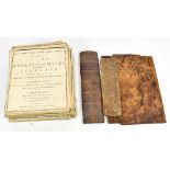
JOHN CARY; 'Cary's New Map of England and Wales with Part of Scotland', pub. June 11th 1794, 76
JOHN CARY; 'Cary's New Map of England and Wales with Part of Scotland', pub. June 11th 1794, 76 pages in total and with original spine and back bo...
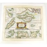
ROBERT MORDEN; 'The Smaller Islands in the British Ocean', a late 17th century and later coloured
ROBERT MORDEN; 'The Smaller Islands in the British Ocean', a late 17th century and later coloured map sold by Able Swale, Awnsham & John Churchill...