Filtered by:
- Category,
- Item Type
- List
- Grid
A subscription to the Price Guide is required to view results for auctions ten days or older. Click here for more information
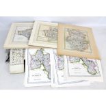

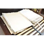
A group of maps, unframed, some mounted, predominantly late 19th/early 20th century, including
A group of maps, unframed, some mounted, predominantly late 19th/early 20th century, including some modern reproductions. ...[more]
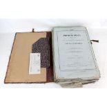
H. BERGHAUS & A. KEITH JOHNSTONE; 'The Physical Atlas; A Series of Maps Illustrating the Geographical Distribution of Natural Phenomena', parts I-...

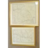
AFTER PIERRE M LAPIE; a hand coloured engraved map, 'Carte des Gaules', 41 x 56cm, framed and
AFTER PIERRE M LAPIE; a hand coloured engraved map, 'Carte des Gaules', 41 x 56cm, framed and glazed, and a further example (2).
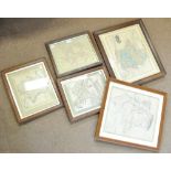
Five engraved maps of France including 'Ancient France' after T Hewett Key, 38 x 32cm, all framed
Five engraved maps of France including 'Ancient France' after T Hewett Key, 38 x 32cm, all framed and glazed (5).
AFTER J CARY; a 19th century engraved map, 'A Map of The Principal Roman Camps, Forts, Walls & Sea
AFTER J CARY; a 19th century engraved map, 'A Map of The Principal Roman Camps, Forts, Walls & Sea Between the River Tyne in England and Tay in Sc...
A large quantity of 20th century Ordinance Survey maps and plans.