Verfeinern Sie Ihre Suche
Auktionshaus-Kategorie
- 20th Century Memorabilia (8)
- Books (12)
- Boxes & Caddies (6)
- British & Continental Ceramics (53)
- Carpets (6)
- Chinese Ceramics and Works of Art (41)
- Clocks & Barometers (29)
- Furniture: 18th Century & Earlier (15)
- Furniture: Arts & Crafts, Nouveau, Edwardian & Art Deco (26)
- Furniture: George III & Regency (26)
- Furniture: Mid Century & Contemporary (7)
- Furniture: William IV & Victorian (75)
- Garden Furniture & Statuary (12)
- Glass ware (21)
- Historical Documents & Papers (3)
- Japanese Ceramics and Works of Art (10)
- Jewellery (85)
- Lighting (18)
- Maps (49)
- Metal wares (7)
- Militaria (11)
- Mirrors (10)
- Musical Instuments (4)
- Objects of Virtue (14)
- Oil Paintings (61)
- Prints (21)
- Silver (50)
- Silver Plated wares (5)
- Sovereigns, Half Sovereigns & Coins (6)
- Taxidermy (4)
- Textiles (16)
- Toys, Games & Diecast vehicles (7)
- Treen & Venacular Items (6)
- Uhren (19)
- Vintage ephemera (19)
- Watercolours & Drawings (38)
- Works of Art (28)
Schätzpreis
Kategorie
- Furniture (174)
- Jewellery (87)
- Oil, Acrylic paintings & Mixed Media (64)
- Maps (49)
- Silver & Silver-plated items (44)
- Porcelain (36)
- Watercolours (29)
- Clocks (28)
- Glassware (27)
- Ceramics (26)
- Lighting (23)
- Collectables (20)
- Chinese Works of Art (18)
- Watches & Watch accessories (18)
- Books & Periodicals (17)
- Prints (17)
- Arms, Armour & Militaria (16)
- Salvage & Architectural Antiques (16)
- Sculpture (14)
- Japanese Works of Art (11)
- Models, Toys, Dolls & Games (11)
- Drawings & Pastels (10)
- Musical Instruments & Memorabilia (10)
- Taxidermy & Natural History (10)
- Carpets & Rugs (9)
- Vintage Fashion (9)
- Metalware (8)
- Coins (5)
- Textiles (5)
- Cameras & Camera Equipment (4)
- Ethnographica & Tribal Art (2)
- Fine Art (2)
- Indian Works of Art (2)
- Scientific Instruments (2)
- Barometers (1)
- Classic Cars, Motorcycles & Automobilia (1)
- Entertainment Memorabilia (1)
- Photographs (1)
- Stamps (1)
- Writing Instruments (1)
Sortieren nach:
- Künstler / Marke
- Liste
- Galerie
Ein Abonnement der Preisliste ist notwendig um Ergebnisse, von Auktionen die vor einem längeren Zeitraum als 10 Tagen stattgefunden haben, ansehen zu können. Klicken Sie hier für mehr Informationen
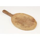

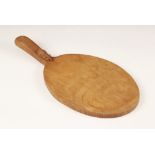
Workshop of Robert 'Mouseman' Thompson, Kilburn, a cheese board of oval form, with a carved trademark mouse to the handle, 38cm x 18cm
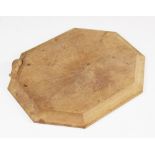
Workshop of Robert 'Mouseman' Thompson, Kilburn, an octagonal breadboard, carved trademark mouse
Workshop of Robert 'Mouseman' Thompson, Kilburn, an octagonal breadboard, carved trademark mouse to the moulded edge, 30cm x 25cm
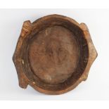
A hand carved elm bowl, 19th century, of shallow circular flat bottomed form with integrated twin
A hand carved elm bowl, 19th century, of shallow circular flat bottomed form with integrated twin handles, 54cm wide (various historic repairs)
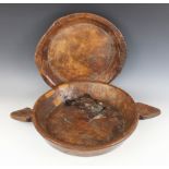
A carved elm twin handled dish, early 19th century, of wide flat-bottomed form, showing later
A carved elm twin handled dish, early 19th century, of wide flat-bottomed form, showing later repairs, 42cm diameter, 59.5cm W (max) x 7cm H, with...
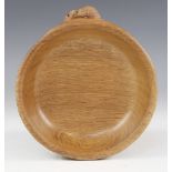
Workshop of Robert "Mouseman" Thompson of Kilburn, a carved oak bowl, of circular form, the signature mouse carved to the exterior, 16cm diameter
Workshop of Robert "Mouseman" Thompson of Kilburn, a carved oak cheese board, of oval form, the
Workshop of Robert "Mouseman" Thompson of Kilburn, a carved oak cheese board, of oval form, the signature mouse carved to the handle, 38cm long ov...
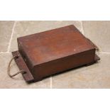
A World War I mahogany ammunition case, of plain rectangular form, with an extended base to rope
A World War I mahogany ammunition case, of plain rectangular form, with an extended base to rope handles, raised upon block feet, 18cm H x 70cm W ...
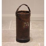
A leather covered shell carrier, late 19th/early 20th century, of typical cylindrical form, with
A leather covered shell carrier, late 19th/early 20th century, of typical cylindrical form, with applied Royal coat of arms and overhead swing han...
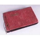
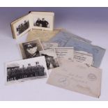
WORLD WAR II INTEREST: A WWII Canadian photograph album containing monochrome photographs of
WORLD WAR II INTEREST: A WWII Canadian photograph album containing monochrome photographs of Canadian service personnel taken in 1943 and 1944, an...
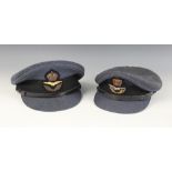
WORLD WAR II INTEREST: A WWII R.A.F. officer's peaked cap by Bates of Jermyn Street, with King's
WORLD WAR II INTEREST: A WWII R.A.F. officer's peaked cap by Bates of Jermyn Street, with King's crown cap badge and maker's mark to the interior ...
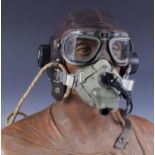
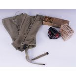
WORLD WAR II INTEREST: A WWII C Type brown leather flying helmet, the chamois leather lining
WORLD WAR II INTEREST: A WWII C Type brown leather flying helmet, the chamois leather lining marked "SIZE 2 6[&]7/8 - 7 10685", the integrated ...
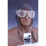
WORLD WAR II INTEREST: A German WWII leather sheepskin lined Luftwaffe winter pattern flying helmet,
WORLD WAR II INTEREST: A German WWII leather sheepskin lined Luftwaffe winter pattern flying helmet, with internal label marked FI. Kopfhaube Gr. ...
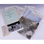
WORLD WAR II INTEREST: A folder of German WWII Operation Sealion bombing maps, titled "Militargeographische Einzelangaben uber England, Militargeo...
WORLD WAR II INTEREST: A WWII German photograph album containing thirty seven 6cm x 9cm monochrome
WORLD WAR II INTEREST: A WWII German photograph album containing thirty seven 6cm x 9cm monochrome photographs depicting scenes of military life, ...
WORLD WAR II INTEREST: A box of American military issue matches manufactured by the Universal
WORLD WAR II INTEREST: A box of American military issue matches manufactured by the Universal Match Corporation of St. Louis, Missouri, the origin...
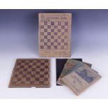
WORLD WAR II INTEREST: A handmade cardboard chess board inscribed "U.S. ARMY P.W.1B FRANCE" and "
WORLD WAR II INTEREST: A handmade cardboard chess board inscribed "U.S. ARMY P.W.1B FRANCE" and "CHARTRES 1945", 29.5cm x 22cm, with a similar exa...
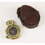
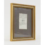
A cased WWI military brass bodied pocket compass, the base with broad arrow, serial number F-L No.
A cased WWI military brass bodied pocket compass, the base with broad arrow, serial number F-L No.124004 and date 1918, the leather case stamped "...
![After Joan [Johannes] Blaeu (1596-1673), DANIA REGNUM, a hand coloured engraved map of Denmark on](https://portal-images.azureedge.net/auctions-2022/trevan10081/images/c538833c-de1d-41a4-a68d-af25009b54ce.jpg?w=155&h=155)
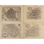
After Joan [Johannes] Blaeu (1596-1673), DANIA REGNUM, a hand coloured engraved map of Denmark on
After Joan [Johannes] Blaeu (1596-1673), DANIA REGNUM, a hand coloured engraved map of Denmark on laid paper, circa 1650, contemporary gilt highli...
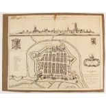
![After Joan [Johannes] Blaeu (1596-1673), VESALIA VULGO WESEL, a hand coloured engraved map on laid](https://portal-images.azureedge.net/auctions-2022/trevan10081/images/45debc66-8ee3-4ebe-b99c-af25009b55dc.jpg?w=155&h=155)
After Joan [Johannes] Blaeu (1596-1673), VESALIA VULGO WESEL, a hand coloured engraved map on laid
After Joan [Johannes] Blaeu (1596-1673), VESALIA VULGO WESEL, a hand coloured engraved map on laid paper depicting a bird's eye view of the city ...
After Antoon Sanders (1586-1664), NEOPORTUS VERNACULE NIEUPORT, an uncoloured engraved map on laid
After Antoon Sanders (1586-1664), NEOPORTUS VERNACULE NIEUPORT, an uncoloured engraved map on laid paper depicting a bird's eye view of the city o...
After Paul Rapin de Thoyras (1661-1725), MECHLIN, OR MALINES THE CAPITAL OF ONE OF THE TEN PROVINCES
After Paul Rapin de Thoyras (1661-1725), MECHLIN, OR MALINES THE CAPITAL OF ONE OF THE TEN PROVINCES OF THE NETHERLANDS IN BRABANTAN ARCHBISHOPRIC...
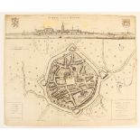
![ALOSTUM, URBS FLAN DRIAE IMPERATORIAE FIRMISSIMA [Aalst, a very strong city in Imperial Flanders], a](https://portal-images.azureedge.net/auctions-2022/trevan10081/images/77deae20-9f8b-4fef-bcbf-af25009b58c1.jpg?w=155&h=155)
ALOSTUM, URBS FLAN DRIAE IMPERATORIAE FIRMISSIMA [Aalst, a very strong city in Imperial Flanders], a
ALOSTUM, URBS FLAN DRIAE IMPERATORIAE FIRMISSIMA [Aalst, a very strong city in Imperial Flanders], a hand coloured engraved map on laid paper, pub...
After Antoon Sanders (1586-1664), FURNA VERNACULE VEURNE, an uncoloured engraved map on laid paper
After Antoon Sanders (1586-1664), FURNA VERNACULE VEURNE, an uncoloured engraved map on laid paper depicting a bird's eye view of the city of Veur...
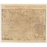
After Henri Abraham Chatelain (1684-1743), CARTE NOUVELLE DE LA GRANDE TARTARIE OU DE L'EMPIRE DU
After Henri Abraham Chatelain (1684-1743), CARTE NOUVELLE DE LA GRANDE TARTARIE OU DE L'EMPIRE DU GRAND CHAM [...], an uncoloured engraved map on ...
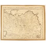
After Sigismund Herberstein (1486-1566), MOSCOVIA SIGISMUNDI LIBERI BARONIS IN HERBERSTAIN, an
After Sigismund Herberstein (1486-1566), MOSCOVIA SIGISMUNDI LIBERI BARONIS IN HERBERSTAIN, an uncoloured woodcut engraved map on laid paper depic...
After Lodovico Guicciardini (1521-1589), HOLLANDIAE CATTORUM REGIONIS TYPUS, an uncoloured engraved map on laid paper depicting Holland, with tall...
After Lodovico Guicciardini (1521-1589), RUINARUM ARCIS BRITANNICAE APUD BATSVOS TYPUS, an uncoloured engraved map on laid paper depicting the rui...
After Lodovico Guicciardini (1521-1589), LEWARDUM OCCIDENTALIS FRISIAE OPP: 1581, an uncoloured
After Lodovico Guicciardini (1521-1589), LEWARDUM OCCIDENTALIS FRISIAE OPP: 1581, an uncoloured engraved map on laid paper depicting a bird's eye ...
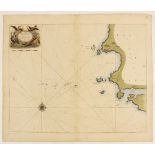
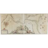
After Captain Greenvile Collins (British, 1643-1694), Hydrographer to their Majesties, MILFORD HAVEN
After Captain Greenvile Collins (British, 1643-1694), Hydrographer to their Majesties, MILFORD HAVEN AND THE ISLANDS ADJACENT MOSTHUMBLY DEDICATED...
![After Joan [Johannes] Blaeu (1596-1673), ANTVERPIA; GALLIS ANVERS. VERNACULE ANTWERPEN, an](https://portal-images.azureedge.net/auctions-2022/trevan10081/images/6573514d-e775-4738-996a-af25009b60ca.jpg?w=155&h=155)
After Joan [Johannes] Blaeu (1596-1673), ANTVERPIA; GALLIS ANVERS. VERNACULE ANTWERPEN, an uncoloured engraved map on laid paper depicting the cit...
A MAPP OF ST. ANDREWS HOLBORN PARISH AS WELL WITHIN THE LIBERTY AS WITHOUT. TAKEN FROM THE LAST
A MAPP OF ST. ANDREWS HOLBORN PARISH AS WELL WITHIN THE LIBERTY AS WITHOUT. TAKEN FROM THE LAST SURVEY, WITH CORRECTIONS AND ENLARGEMENTS, an unco...
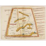
A hand coloured woodcut Ptolemaic map of Central Asia north of the Himalayas, early 16th century,
A hand coloured woodcut Ptolemaic map of Central Asia north of the Himalayas, early 16th century, divided into "Scithia Extra Imaum" [Scythia Outs...
After Gerard Mercator (1512-1594), three engraved maps on laid paper from French editions of the
After Gerard Mercator (1512-1594), three engraved maps on laid paper from French editions of the Mercator-Hondius "Atlas sive cosmographicae medit...
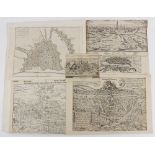
After John Bill (b.1576), twelve uncoloured engraved maps on laid paper each depicting a county of
After John Bill (b.1576), twelve uncoloured engraved maps on laid paper each depicting a county of Wales, comprising: CARNARVAN THE ISLE OF ANGLES...
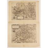
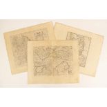
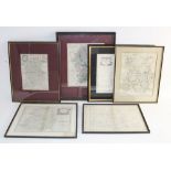
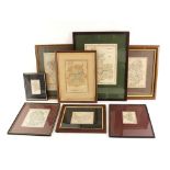
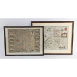
A collection of unframed British county maps, 17th century and later, to include: after John
A collection of unframed British county maps, 17th century and later, to include: after John Speed (1552-1629), SHROPSHYRE DESCRIBED THE SITUATION...
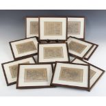
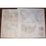
A collection of eleven unframed continental, country and regional maps, 18th century and later, to
A collection of eleven unframed continental, country and regional maps, 18th century and later, to include: after Nicholas de Fer (1646-1720), PRO...
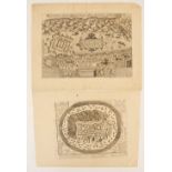
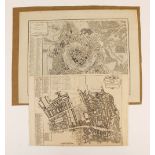
HERBIPOLIS - WIRTZBURG, an uncoloured woodcut map on laid paper depicting a bird's eye view of
HERBIPOLIS - WIRTZBURG, an uncoloured woodcut map on laid paper depicting a bird's eye view of Wurzburg, published for the 1574 German edition of ...
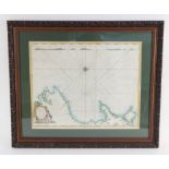
After Captain Greenvile Collins (British, 1643-1694), THE RIVER AVON FROM THE SEVERN TO THE CITTY OF
After Captain Greenvile Collins (British, 1643-1694), THE RIVER AVON FROM THE SEVERN TO THE CITTY OF BRISTOLL, an engraved chart on two joined she...
After Captain Greenvile Collins (British, 1643-1694), an engraved naval chart on laid paper depicting the Welsh coast around Cardigan Bay with sou...
![After John Ogilby (1600-1676), THE CONTINUATION OF THE ROAD FROM LONDON TO HOLYHEAD [plate 3]](https://portal-images.azureedge.net/auctions-2022/trevan10081/images/f9948696-7a75-48dd-afb0-af25009b6a19.jpg?w=155&h=155)
After John Ogilby (1600-1676), THE CONTINUATION OF THE ROAD FROM LONDON TO HOLYHEAD [plate 3]
After John Ogilby (1600-1676), THE CONTINUATION OF THE ROAD FROM LONDON TO HOLYHEAD [plate 3] COMENCING AT THE CITY OF LICHFIELD & EXTENDING TO TH...
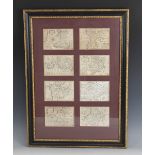
After John Speed (1552-1629), eight uncoloured engraved maps on laid paper, comprising: WALES;
After John Speed (1552-1629), eight uncoloured engraved maps on laid paper, comprising: WALES; ANGLESEY AND CARNARVAN; GLAMORGAN SHIRE; MONMOUTH S...
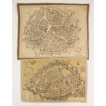
![After Johannes Janssonius [Jan Jansson/Jan Janszoon] (1588-1664), DUCATUS EBORACENSIS ANGLICE](https://portal-images.azureedge.net/auctions-2022/trevan10081/images/56fcb2e3-1596-4291-bc06-af25009b6bf3.jpg?w=155&h=155)
After Johannes Janssonius [Jan Jansson/Jan Janszoon] (1588-1664), DUCATUS EBORACENSIS ANGLICE
After Johannes Janssonius [Jan Jansson/Jan Janszoon] (1588-1664), DUCATUS EBORACENSIS ANGLICE YORKSHIRE, an engraved map on paper depicting the co...
![After Joan [Johannes] Blaeu (1596-1673), COMITATUS CAERNARVONIENSIS; Vernacule CARNARVON-SHIRE. ET](https://portal-images.azureedge.net/auctions-2022/trevan10081/images/60a61a05-7a78-4301-ba7a-af25009b6d02.jpg?w=155&h=155)
After Joan [Johannes] Blaeu (1596-1673), COMITATUS CAERNARVONIENSIS; Vernacule CARNARVON-SHIRE. ET
After Joan [Johannes] Blaeu (1596-1673), COMITATUS CAERNARVONIENSIS; Vernacule CARNARVON-SHIRE. ET MONA INSULA VULGO ANGLESEY, an engraved map on ...
![After Joan [Johannes] Blaeu (1596-1673), CESTRIA COMITATUS PALATINUS, an engraved map on laid](https://portal-images.azureedge.net/auctions-2022/trevan10081/images/789ec084-ff17-4b7a-94b6-af25009b6dfa.jpg?w=155&h=155)
After Joan [Johannes] Blaeu (1596-1673), CESTRIA COMITATUS PALATINUS, an engraved map on laid
After Joan [Johannes] Blaeu (1596-1673), CESTRIA COMITATUS PALATINUS, an engraved map on laid paper depicting the County Palatine Of Cheshire, cir...
![After Johannes Janssonius [Jan Jansson/Jan Janszoon] (1588-1664), PROVINCIA CONNACHTIAE, an engraved](https://portal-images.azureedge.net/auctions-2022/trevan10081/images/bcd2bb89-551f-45b6-8efd-af25009b6ec5.jpg?w=155&h=155)
After Johannes Janssonius [Jan Jansson/Jan Janszoon] (1588-1664), PROVINCIA CONNACHTIAE, an engraved
After Johannes Janssonius [Jan Jansson/Jan Janszoon] (1588-1664), PROVINCIA CONNACHTIAE, an engraved map on paper depicting the province of Connau...
![After Ortelius [Abraham Ortel] (1528-1598) and Humphrey Lhuyd (1527-1568), CAMBRIAE TYPUS AUCTORE](https://portal-images.azureedge.net/auctions-2022/trevan10081/images/016f9f9c-b6ae-4069-b78c-af25009b6fb4.jpg?w=155&h=155)
After Ortelius [Abraham Ortel] (1528-1598) and Humphrey Lhuyd (1527-1568), CAMBRIAE TYPUS AUCTORE
After Ortelius [Abraham Ortel] (1528-1598) and Humphrey Lhuyd (1527-1568), CAMBRIAE TYPUS AUCTORE HUMFREDO LHUYDO DENBIGIENSE CAMBROBRITANO, an en...
![After Ortelius [Abraham Ortel] (1528-1598) and Humphrey Lhuyd (1527-1568), CAMBRIAE TYPUS AUCTORE](https://portal-images.azureedge.net/auctions-2022/trevan10081/images/8cbe5307-bf10-4ef9-8a19-af25009b7098.jpg?w=155&h=155)
After Ortelius [Abraham Ortel] (1528-1598) and Humphrey Lhuyd (1527-1568), CAMBRIAE TYPUS AUCTORE
After Ortelius [Abraham Ortel] (1528-1598) and Humphrey Lhuyd (1527-1568), CAMBRIAE TYPUS AUCTORE HUMFREDO LHUYDO DENBIGIENSE CAMBROBRITANO, an en...
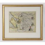
After Michael Drayton (1563-1631) and William Hole (fl. c. 1601 - 1624), CHES SHYRE, an engraved map
After Michael Drayton (1563-1631) and William Hole (fl. c. 1601 - 1624), CHES SHYRE, an engraved map on paper depicting the county of Cheshire wit...
After John Speed (1552-1629), MONTGOMERY SHIRE, an engraved uncoloured map on paper, strapwork title
After John Speed (1552-1629), MONTGOMERY SHIRE, an engraved uncoloured map on paper, strapwork title cartouche, inset Montgomery town plan, first ...
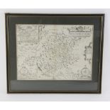
After Robert Morden (1650 – 1703), SHROP SHIRE, an uncoloured engraved map on laid paper depicting
After Robert Morden (1650 – 1703), SHROP SHIRE, an uncoloured engraved map on laid paper depicting the county of Shropshire circa 1695, visible pl...
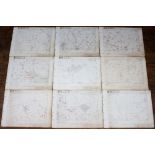
A portfolio containing a series of survey maps for MERSEYSIDE AND NORTH WALES ELECTRICITY BOARD
A portfolio containing a series of survey maps for MERSEYSIDE AND NORTH WALES ELECTRICITY BOARD SUB-AREA No.4 CHESHIRE, each dated 1948, to the or...
After Robert Morden (1650-1703), a selection of unframed engraved maps on laid paper, comprising:
After Robert Morden (1650-1703), a selection of unframed engraved maps on laid paper, comprising: SHROP SHIRE (two copies), STAFFORD SHIRE, and HU...
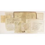
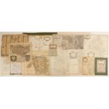
A folio containing loose pages from a George Philip & Son Atlas, probably circa 1911, with a
A folio containing loose pages from a George Philip & Son Atlas, probably circa 1911, with a selection of pages from other atlases, and a miscella...
![After Robert Plot (1640-1696), THIS MAP OF STAFFORSHIRE NEWLY DELINEATED [...], an engraved](https://portal-images.azureedge.net/auctions-2022/trevan10081/images/4aa8a21a-72eb-4def-a4de-af25009b7519.jpg?w=155&h=155)
After Robert Plot (1640-1696), THIS MAP OF STAFFORSHIRE NEWLY DELINEATED [...], an engraved uncoloured map on paper, the title cartouche with can...
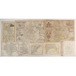
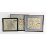
Eight English county maps, 19th century and later, to include maps of Cheshire, The County Palatine Of Chester, Shropshire, Staffordshire and Lanc...

After Christopher Saxton (1540-1610), SALOPIAE COMITATUS QUEM CORNAUII OLIM INCOLUERUNT DESCRIPTIO, an engraved map on laid paper depicting Shrops...
![After Ortelius [Abraham Ortel] (1528-1598), SCOTIAE TABULA, an engraved map on laid paper](https://portal-images.azureedge.net/auctions-2022/trevan10081/images/65c16526-ffbe-402b-9a2c-af25009b78d0.jpg?w=155&h=155)
After Ortelius [Abraham Ortel] (1528-1598), SCOTIAE TABULA, an engraved map on laid paper depicting Scotland orientated to the west, published by ...
After John Speed (1552-1629), WALES, an engraved map on paper, twelve oval vignettes of principal
After John Speed (1552-1629), WALES, an engraved map on paper, twelve oval vignettes of principal cities to the vertical margins and inset views o...
An engraved playing card map in the manner of William Redmayne, depicting the county of WESTMORLAND as the seven of diamonds, with a large uncolou...