Sortieren nach:
- Kategorie
- Liste
- Galerie
Ein Abonnement der Preisliste ist notwendig um Ergebnisse, von Auktionen die vor einem längeren Zeitraum als 10 Tagen stattgefunden haben, ansehen zu können. Klicken Sie hier für mehr Informationen
![[HANNAH MORE]: THE APPRENTICE TURNED MASTER OR THE SECOND PART OF THE TWO SHOEMAKERS..., London, J](https://portal-images.azureedge.net/auctions-2020/srkey10352/images/1408a678-c77c-4f46-839a-abca0099d8c4.jpg?w=155&h=155)

[HANNAH MORE]: THE APPRENTICE TURNED MASTER OR THE SECOND PART OF THE TWO SHOEMAKERS..., London, J
[HANNAH MORE]: THE APPRENTICE TURNED MASTER OR THE SECOND PART OF THE TWO SHOEMAKERS..., London, J Marshall, printer to the Cheap Repository, Bath...
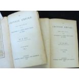
EVARISTE REGIS HUC: THE CHINESE EMPIRE FORMING A SEQUEL TO THE WORK ENTITLED "RECOLLECTIONS OF A
EVARISTE REGIS HUC: THE CHINESE EMPIRE FORMING A SEQUEL TO THE WORK ENTITLED "RECOLLECTIONS OF A JOURNEY THROUGH TARTARY AND THIBET", London, Long...
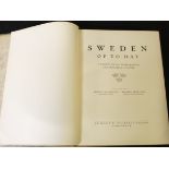
MAGNUS BLOMSTEDT AND FREDRIK BOOK (EDS): SWEDEN OF TO-DAY, A SURVEY OF ITS INTELLECTUAL AND MATERIAL
MAGNUS BLOMSTEDT AND FREDRIK BOOK (EDS): SWEDEN OF TO-DAY, A SURVEY OF ITS INTELLECTUAL AND MATERIAL CULTURE, Stockholm, 1930, 1st edition, 4to, o...
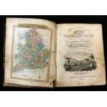
LEWIS'S NEW TRAVELLERS GUIDE FOR A POCKET EDITION OF THE ENGLISH COUNTIES CONTAINING ALL THE
LEWIS'S NEW TRAVELLERS GUIDE FOR A POCKET EDITION OF THE ENGLISH COUNTIES CONTAINING ALL THE DIRECT AND CROSS ROADS IN ENGLAND AND WALES, London, ...
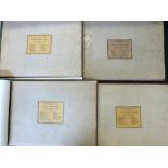
FRANCIS STONE: PICTURESQUE VIEWS OF ALL THE BRIDGES BELONGING IN THE COUNTY OF NORFOLK..., Engelmann
FRANCIS STONE: PICTURESQUE VIEWS OF ALL THE BRIDGES BELONGING IN THE COUNTY OF NORFOLK..., Engelmann Graf Coindet & Co, 1830-31, 1st edition, 4 vo...
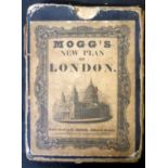
EDWARD MOGG: MOGG'S NEW PLAN OF LONDON, engraved part hand coloured plan 1837, 32 sections backed
EDWARD MOGG: MOGG'S NEW PLAN OF LONDON, engraved part hand coloured plan 1837, 32 sections backed onto linen, approximately 560 x 990mm, original ...
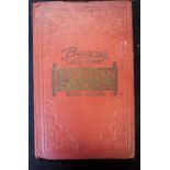
G W BACON (PUB): BACON'S LARGE-PRINT MAP OF LONDON AND SUBURBS WITH GUIDE, (cover title), circa
G W BACON (PUB): BACON'S LARGE-PRINT MAP OF LONDON AND SUBURBS WITH GUIDE, (cover title), circa 1895, large scale coloured folding map, approx 690...
*JOHANNES BLAEU: CANTIUM VERNACULE KENT, engraved hand coloured map circa 1645, approx 380 x 520mm,
*JOHANNES BLAEU: CANTIUM VERNACULE KENT, engraved hand coloured map circa 1645, approx 380 x 520mm, framed and glazed ...[more]
*ROBERT MORDEN: DEVONSHIRE, engraved hand coloured map circa 1753, approx 358 x 470mm, framed and
*ROBERT MORDEN: DEVONSHIRE, engraved hand coloured map circa 1753, approx 358 x 470mm, framed and glazed ...[more]
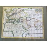
*JEAN LE CLERC/NICHOLAS SANSON: LA TERRE CONNUE LORSQUE L'EVANGIL SUT PUBLIE, engraved hand coloured maps circa 1705, inset double hemisphere worl...
![*ROBERT MORDEN: COMITATUS DEN ROTLANDIAE TABULA NOVA AUCTA [RUTLAND], engraved map [circa 1695],](https://portal-images.azureedge.net/auctions-2020/srkey10352/images/65934643-815d-4837-8c98-abca01069c91.jpg?w=155&h=155)
*ROBERT MORDEN: COMITATUS DEN ROTLANDIAE TABULA NOVA AUCTA [RUTLAND], engraved map [circa 1695],
*ROBERT MORDEN: COMITATUS DEN ROTLANDIAE TABULA NOVA AUCTA [RUTLAND], engraved map [circa 1695], framed and glazed, approx size 370 x 290mm ...[m...
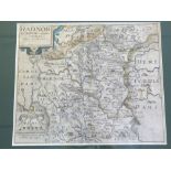
*CHRISTOPHER SAXTON/WILLIAM KIP: RADNOR COMITATUS QUEM SILVRES, engraved part hand coloured map circ
*CHRISTOPHER SAXTON/WILLIAM KIP: RADNOR COMITATUS QUEM SILVRES, engraved part hand coloured map circa 1610, approx 260 x 315mm, framed and glazed ...
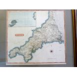
*SAMUEL JOHN NEELE: CORNWALL, engraved hand coloured map pub Cadell & Davies, 1814, inset Scilly
*SAMUEL JOHN NEELE: CORNWALL, engraved hand coloured map pub Cadell & Davies, 1814, inset Scilly Isles, approx 370 x 410mm, framed and glazed ......
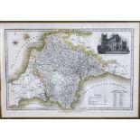
*JAMES PIGOT: DEVONSHIRE, engraved part hand coloured map circa 1844, vignette of Exeter Cathedral,
*JAMES PIGOT: DEVONSHIRE, engraved part hand coloured map circa 1844, vignette of Exeter Cathedral, approx 220 x 345mm, framed and glazed ...[mor...
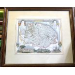
*THOMAS MOULE: NORFOLK, engraved hand coloured map circa 1850, approx 200 x 260mm, framed and glazed
*THOMAS MOULE: NORFOLK, engraved hand coloured map circa 1850, approx 200 x 260mm, framed and glazed ...[more]
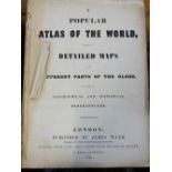
JAMES WYLD: A POPULAR ATLAS OF THE WORLD CONSISTENT OF DETAILED MAPS OF THE DIFFERENT PARTS OF THE
JAMES WYLD: A POPULAR ATLAS OF THE WORLD CONSISTENT OF DETAILED MAPS OF THE DIFFERENT PARTS OF THE GLOBE, London, James Wyld, 1849, 46 engraved ou...
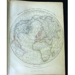
JOSEPH WILSON LOWRY: LOWRY'S TABLE ATLAS..., London, circa 1852, 65 maps on 100 sheets, 4to, old
JOSEPH WILSON LOWRY: LOWRY'S TABLE ATLAS..., London, circa 1852, 65 maps on 100 sheets, 4to, old half calf worn
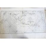
ALEXIS HUBERT JAILLOT: CARTE DE L'ENTREE DE LA TAMISE AVEC LES BANCS PASSES ISLES ET COSTES COMPRISES ENTRE SANDWICH ET CLAY, Paris, circa 1760, e...
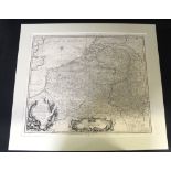
CLAUDE DU BOSE: A MAP OF FLANDERS AND OTHER PROVINCES OF THE NETHERLANDS WITH PART OF ENGLAND,
CLAUDE DU BOSE: A MAP OF FLANDERS AND OTHER PROVINCES OF THE NETHERLANDS WITH PART OF ENGLAND, HOLLAND, FRANCE ETC, engraved map circa 1735, appro...
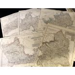
Approx 34 county maps including CHESHIRE, BEDFORDSHIRE, NORTHUMBERLAND, BERKSHIRE, HEREFORDSHIRE,
Approx 34 county maps including CHESHIRE, BEDFORDSHIRE, NORTHUMBERLAND, BERKSHIRE, HEREFORDSHIRE, HAMPSHIRE, DEVONSHIRE etc, approx 820 x 540mm
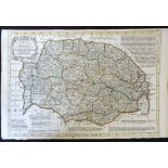
EMANUEL BOWEN: NORFOLK DIVIDED INTO ITS HUNDREDS..., engraved hand coloured map circa 1767, approx
EMANUEL BOWEN: NORFOLK DIVIDED INTO ITS HUNDREDS..., engraved hand coloured map circa 1767, approx 230 x 335mm
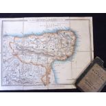
![SAMUEL JOHN NEELE: MAP OF THE SOIL OF NORFOLK, engraved hand coloured map [1804], top edge](https://portal-images.azureedge.net/auctions-2020/srkey10352/images/a068847c-8b29-4793-aa99-abca0106c4aa.jpg?w=155&h=155)
SAMUEL JOHN NEELE: MAP OF THE SOIL OF NORFOLK, engraved hand coloured map [1804], top edge reinforced, approx 245 x 300mm
![JACOB VAN LANGEREN: NORTHFOLKE, engraved map [1643], approx 100 x 100mm](https://portal-images.azureedge.net/auctions-2020/srkey10352/images/93fd3e3e-9834-438f-bd77-abca0106c9b2.jpg?w=155&h=155)
JACOB VAN LANGEREN: NORTHFOLKE, engraved map [1643], approx 100 x 100mm
![PIETER VAN DEN KEERE: NORFOLCIA, engraved map (miniature speed) [1617], approx 85 x 120mm](https://portal-images.azureedge.net/auctions-2020/srkey10352/images/ec80250c-6fb7-45ce-b774-abca0106ca6b.jpg?w=155&h=155)
PIETER VAN DEN KEERE: NORFOLCIA, engraved map (miniature speed) [1617], approx 85 x 120mm
G F CRUCHLEY: CRUCHLEY'S ENVIRONS OF MARGATE INCLUDING RAMSGATE, BROADSTAIRS, SANDWICH ETC, engraved
G F CRUCHLEY: CRUCHLEY'S ENVIRONS OF MARGATE INCLUDING RAMSGATE, BROADSTAIRS, SANDWICH ETC, engraved hand coloured map circa 1850, approx 250 x 28...